...HEAVY RAINS AND STRONG WINDS CONTINUING ACROSS THE CAYMAN ISLANDS...
Tropical Storm Grace Intermediate Advisory Number 20A
NWS National Hurricane Center Miami FL AL072021
800 AM EDT Wed Aug 18 2021
SUMMARY OF 800 AM EDT...1200 UTC...INFORMATION
----------------------------------------------
LOCATION...19.1N 81.4W
ABOUT 20 MI...30 KM SW OF GRAND CAYMAN
ABOUT 405 MI...650 KM ESE OF TULUM MEXICO
MAXIMUM SUSTAINED WINDS...65 MPH...100 KM/H
PRESENT MOVEMENT...WNW OR 285 DEGREES AT 16 MPH...26 KM/H
MINIMUM CENTRAL PRESSURE...993 MB...29.32 INCHES
WATCHES AND WARNINGS
--------------------
CHANGES WITH THIS ADVISORY:
None.
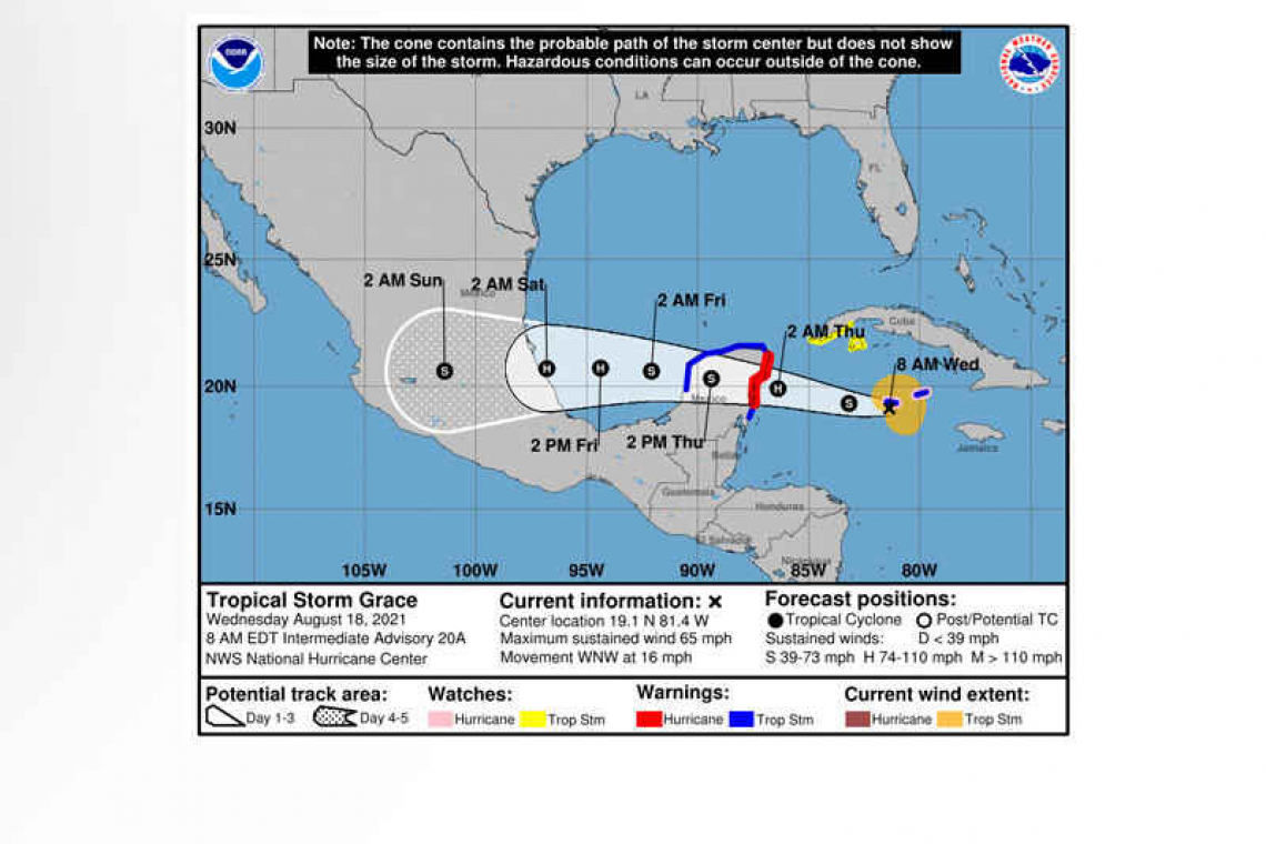
SUMMARY OF WATCHES AND WARNINGS IN EFFECT:
A Hurricane Warning is in effect for...
* Yucatan Peninsula of Mexico from Cancun to Punta Herrero, including Cozumel
A Hurricane Watch is in effect for...
* Cayman Islands
A Tropical Storm Warning is in effect for...
* Cayman Islands
* Yucatan Peninsula of Mexico from north of Cancun to Campeche
* Yucatan Peninsula of Mexico from south of Punta Herrero to Puerto Costa Maya
A Tropical Storm Watch is in effect for...
* Southern coast Cuban province of Pinar del Rio, as well as Isla de la Juventud

A Hurricane Warning means that hurricane conditions are expected somewhere within the warning area. A warning is typically issued 36 hours before the anticipated first occurrence of tropical-storm-force winds, conditions that make outside preparations difficult or dangerous. Preparations to protect life and property should be rushed to completion.
A Hurricane Watch means that hurricane conditions are possible within the watch area.
A Tropical Storm Warning means that tropical storm conditions are expected somewhere within the warning area within 36 hours.
A Tropical Storm Watch means that tropical storm conditions are possible within the watch area.
Interests elsewhere in the Yucatan Peninsula of Mexico should monitor the progress of Grace. Additional watches or warnings may be required later this morning.
For storm information specific to your area, please monitor products issued by your national meteorological service.
DISCUSSION AND OUTLOOK
----------------------
At 800 AM EDT (1200 UTC), the center of Tropical Storm Grace was located by an Air Force Reserve Hurricane Hunter aircraft near latitude 18.8 North, longitude 80.9 West. Grace is moving toward the west-northwest near 16 mph (26 km/h). A general westward to west-northwestward motion is expected for the next several days. On the forecast track, the center of Grace will continue to move near or over the Cayman Islands later this morning. Grace is expected to make landfall in the Yucatan peninsula of Mexico early Thursday, and move into the southwest Gulf of Mexico early Friday.
Maximum sustained winds are near 65 mph (100 km/h) with higher gusts. Grace is forecast to strengthen into a hurricane later today, with some additional strengthening possible prior to the center reaching the eastern Yucatan Peninsula.
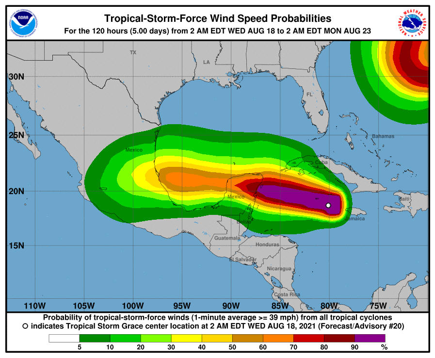
Tropical-storm-force winds extend outward up to 115 miles (185 km) from the center. Wind gusts to hurricane force have been reported on Grand Cayman.
The minimum central pressure estimated from Air Force Hurricane Hunter observations is 993 mb (29.32 inches).
HAZARDS AFFECTING LAND
----------------------
WIND: Tropical storm conditions are expected, and hurricane conditions are possible, over the Cayman Islands through this morning. Tropical storm conditions are possible along the southern coast of Cuba within the watch area through today. Hurricane conditions are expected within the warning area in the Yucatan Peninsula of Mexico late tonight, with tropical storm conditions beginning as early as this evening.
RAINFALL: Grace is expected to produce the following rainfall amounts:
Over Jamaica, the Cayman Islands, portions of the Yucatan Peninsula and Vera Cruz state....4 to 8 inches of rain with isolated maximum totals of 12 inches are expected through Friday night. This heavy rainfall could lead to flash and urban flooding, with mudslides possible in Jamaica.
STORM SURGE: A storm surge could raise water levels as high as 1 to 3 ft above normal tide levels in portions of the Cayman Islands.
A dangerous storm surge will raise water levels by as much as 3 to 5 ft above normal tide levels along the immediate coast near and to the north of where the center makes landfall in the northeastern Yucatan Peninsula late tonight or early Thursday. Near the coast, the surge will be accompanied by large and destructive waves.
SURF: Swells generated by Grace will spread westward from Jamaica to the Cayman Islands, the southern coast of Cuba, and the Yucatan Peninsula of Mexico. These swells are likely to cause life-threatening surf and rip current conditions. Please consult products from your local weather office.
Forecaster Pasch


