NWS National Hurricane Center Miami FL AL042022
...AIR FORCE HURRICANE HUNTER AIRCRAFT ENROUTE TO INVESTIGATE THE DISTURBANCE...
...HEAVY RAINS COULD CAUSE FLASH FLOODS ACROSS PORTIONS OF SOUTH TEXAS AND NORTHEASTERN MEXICO THROUGH SUNDAY MORNING...
SUMMARY OF 700 AM CDT...1200 UTC...INFORMATION
----------------------------------------------
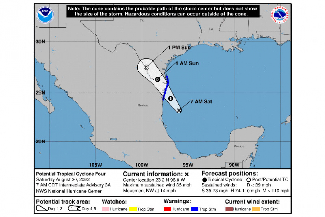
LOCATION...23.2N 96.0W
ABOUT 200 MI...325 KM SSE OF MOUTH OF THE RIO GRANDE
MAXIMUM SUSTAINED WINDS...35 MPH...55 KM/H
PRESENT MOVEMENT...NW OR 320 DEGREES AT 14 MPH...22 KM/H
MINIMUM CENTRAL PRESSURE...1010 MB...29.83 INCHES
WATCHES AND WARNINGS
--------------------
CHANGES WITH THIS ADVISORY:
None.
SUMMARY OF WATCHES AND WARNINGS IN EFFECT:
A Tropical Storm Warning is in effect for...
* The Gulf coast of Mexico from Boca de Catan northward to the Mouth of the Rio Grande
* The Lower Texas coast from Port Mansfield southward to the Mouth of the Rio Grande
A Tropical Storm Warning means that tropical storm conditions are expected somewhere within the warning area, in this case within the next 12 to 24 hours.
For storm information specific to your area in the United States, including possible inland watches and warnings, please
monitor products issued by your local National Weather Service forecast office. For storm information specific to your area
outside of the United States, please monitor products issued by your national meteorological service.
DISCUSSION AND OUTLOOK
----------------------
At 700 AM CDT (1200 UTC), the disturbance was centered near latitude 23.2 North, longitude 96.0 West. The system is moving toward the northwest near 14 mph (22 km/h). A northwestward to north-northwestward motion at a similar forward speed is expected through Sunday. On the forecast track, the disturbance is expected to reach the coast of northeastern Mexico late this afternoon and then move across the Rio Grande Valley tonight and Sunday.
Maximum sustained winds remain near 35 mph (55 km/h) with higher gusts. The disturbance could still strengthen slightly and become a tropical storm later today before reaching the coast of northeastern Mexico.
* Formation chance through 48 hours...high...70 percent.
* Formation chance through 5 days...high...70 percent.
The estimated minimum central pressure is 1010 mb (29.83 inches).
HAZARDS AFFECTING LAND
----------------------
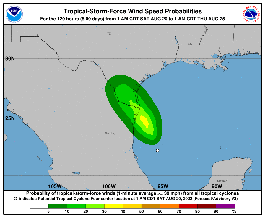
WIND: Tropical storm conditions are expected to occur in the warning area beginning this afternoon or evening.

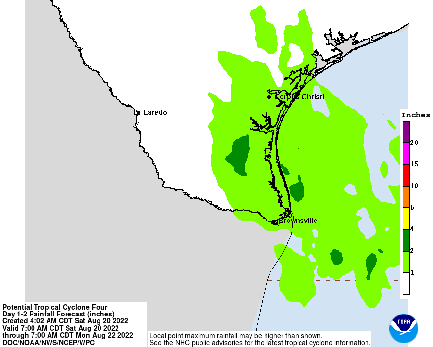
RAINFALL: The disturbance is expected to produce total rainfall amounts of 1 to 3 inches, with isolated totals of 5 inches, along

the eastern coast of Mexico from the northern portions of the state of Veracruz across the state of Tamaulipas to Nuevo Leon through today. Rainfall of 1 to 3 inches will be possible in South Texas through Sunday morning, with continuing uncertainty in how far north and west these amounts will be realized. The potential exists for flash flooding elsewhere along the track of the disturbance.
STORM SURGE: The combination of storm surge and the tide will cause normally dry areas near the coast to be flooded by rising waters moving inland from the shoreline. The water could reach the following heights above ground somewhere in the indicated areas if the peak surge occurs at the time of high tide...
Mouth of Rio Grande to Port Mansfield TX...1-2 ft
Surge-related flooding depends on the relative timing of the surge and the tidal cycle, and can vary greatly over short distances. For information specific to your area, please see products issued by your local National Weather Service forecast office.
Storm surge could raise water levels by as much as 1 to 2 feet above normal tide levels along the immediate coast of northeastern Mexico near and to the north of where the center makes landfall.
SURF: Swells generated by this system are forecast to affect eastern Mexico and southern Texas this weekend. These swells are likely to cause life-threatening surf and rip current conditions. Please consult products from your local weather office.
Forecaster Cangialosi/Latto


