
Hurricane Beryl Advisory Number 9
NWS National Hurricane Center Miami FL AL022024
500 PM AST Sun Jun 30 2024
SUMMARY OF 500 PM AST...2100 UTC...INFORMATION
----------------------------------------------
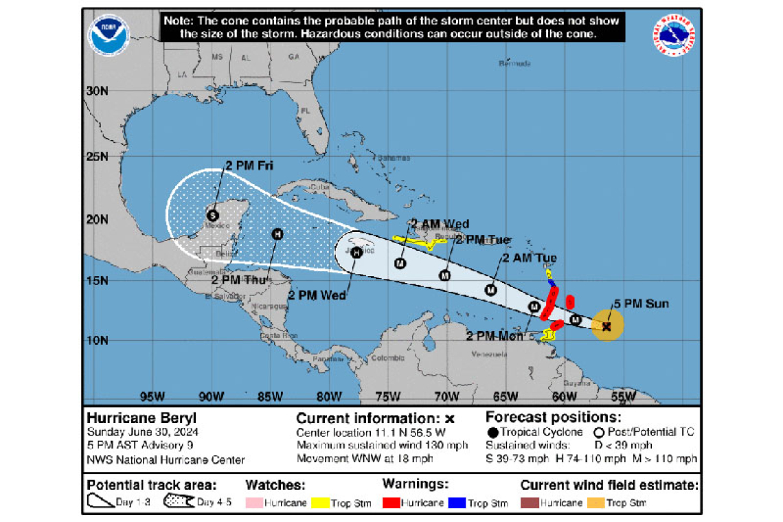
LOCATION...11.1N 56.5W
ABOUT 250 MI...400 KM SE OF BARBADOS
ABOUT 350 MI...565 KM ESE OF ST. VINCENT
MAXIMUM SUSTAINED WINDS...130 MPH...215 KM/H
PRESENT MOVEMENT...WNW OR 285 DEGREES AT 18 MPH...30 KM/H
MINIMUM CENTRAL PRESSURE...960 MB...28.35 INCHES
WATCHES AND WARNINGS
--------------------
CHANGES WITH THIS ADVISORY:
The government of the Dominican Republic has issued a Tropical Storm Watch from Punta Palenque westward to the border with Haiti.
A Tropical Storm Watch has also been issued for the entire south coast of Haiti from the border of the Dominican Republic to Anse d'Hainault.
SUMMARY OF WATCHES AND WARNINGS IN EFFECT:
A Hurricane Warning is in effect for...
* Barbados
* St. Lucia
* St. Vincent and the Grenadine Islands
* Grenada
* Tobago
A Tropical Storm Warning is in effect for...
* Martinique
A Tropical Storm Watch is in effect for...
* Dominica
* Trinidad
* South coast of Dominican Republic from Punta Palenque westward to the border with Haiti
* South coast of Haiti from the border with the Dominican Republic to Anse d'Hainault
A Hurricane Warning means that hurricane conditions are expected somewhere within the warning area. Preparations to protect life and property should be rushed to completion.
A Tropical Storm Warning means that tropical storm conditions are expected somewhere within the warning area within 36 hours.
A Tropical Storm Watch means that tropical storm conditions are possible within the watch area, generally within 48 hours.
Interests elsewhere in the Lesser Antilles, Hispaniola, Jamaica, the Cayman Islands, and the remainder of the northwestern Caribbean should closely monitor the progress of Beryl. Additional watches or warnings may be required tonight or on Monday.
For storm information specific to your area, please monitor products issued by your national meteorological service.
DISCUSSION AND OUTLOOK
----------------------
At 500 PM AST (2100 UTC), the center of Hurricane Beryl was located near latitude 11.1 North, longitude 56.5 West. Beryl is moving toward the west-northwest near 18 mph (30 km/h). A continued quick westward to west-northwestward motion is expected during the next few days. On the forecast track, the center of Beryl is expected to move across the Windward Islands Monday morning and across the southeastern and central Caribbean Sea late Monday through Wednesday.
Maximum sustained winds are near 130 mph (215 km/h) with higher gusts. Beryl is a category 4 hurricane on the Saffir-Simpson Hurricane Wind Scale. Fluctuations in strength are likely during the next day or so, and Beryl is expected to remain an extremely dangerous category 4 hurricane through landfall in the Windward Islands.
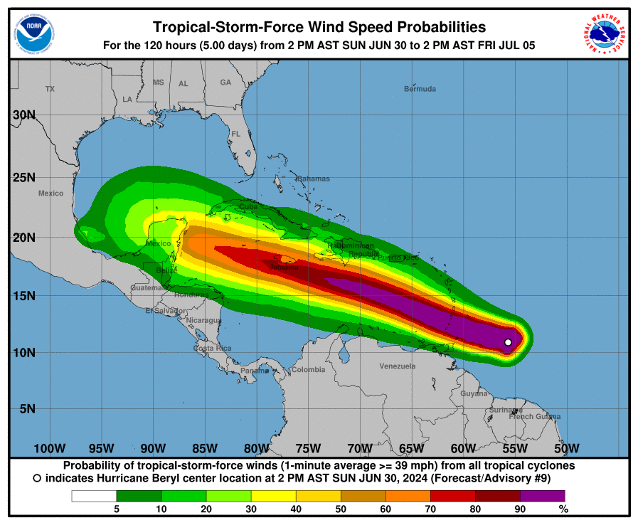
Hurricane-force winds extend outward up to 30 miles (45 km) from the center and tropical-storm-force winds extend outward up to 115 miles (185 km).
The estimated minimum central pressure is 960 mb (28.35 inches).
HAZARDS AFFECTING LAND
----------------------
WIND: Hurricane conditions are expected in the hurricane warning area beginning early Monday morning. Potentially catastrophic wind damage is expected where the eyewall of Beryl moves through portions of the Windward Islands, with the highest risk of the core in St.Vincent and the Grenadines, and Grenada.
Wind speeds atop and on the windward sides of hills and mountains are often up to 30 percent stronger than the near-surface winds indicated in this advisory, and in some elevated locations could be even greater.
Tropical storm conditions are expected in the tropical storm warning area starting late tonight, making outside preparations difficult or dangerous.
Tropical storm conditions are possible within the watch area starting late tonight for Dominica, Trinidad, and by Tuesday afternoon for parts of the southern coast of Hispaniola.
STORM SURGE: A life-threatening storm surge will raise water levels by as much as 6 to 9 feet above normal tide levels in areas of onshore flow near where the eye makes landfall in the hurricane warning area. Near the coast, the surge will be accompanied by large and destructive waves.
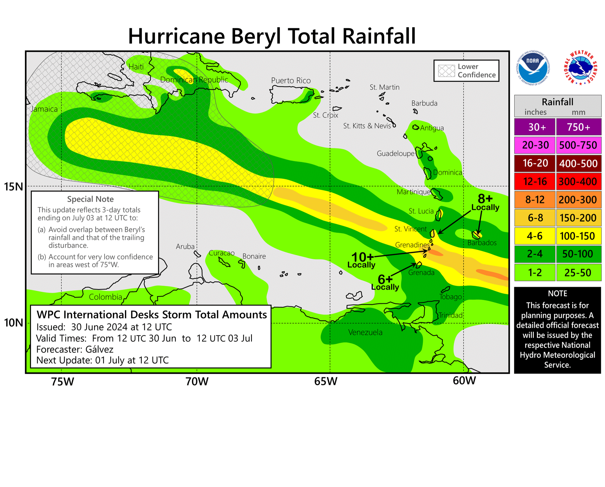
RAINFALL: Hurricane Beryl is expected to produce rainfall totals of 3 to 6 inches across Barbados and the Windward Islands through Monday. Localized maxima of 10 inches is possible, especially in the Grenadines. This rainfall may cause flash flooding in vulnerable areas.
SURF: Large swells generated by Beryl are expected across Windward and southern Leeward Islands during the next couple of days. Swells are also expected to reach the southern coasts of Puerto Rico and Hispaniola in the next day or so. These swells are expected to cause life-threatening surf and rip current conditions. Please consult products from your local weather office.
Forecaster Cangialosi


