NWS National Hurricane Center Miami FL AL032020
700 AM CDT Mon Jun 08 2020
...CRISTOBAL CONTINUES TO MOVE INLAND...
...HEAVY RAINS FORECAST TO SPREAD NORTHWARD...
SUMMARY OF 700 AM CDT...1200 UTC...INFORMATION
----------------------------------------------
LOCATION...31.8N 91.6W
ABOUT 50 MI...75 KM SSE OF MONROE LOUISIANA
MAXIMUM SUSTAINED WINDS...35 MPH...55 KM/H
PRESENT MOVEMENT...NNW OR 330 DEGREES AT 10 MPH...17 KM/H
MINIMUM CENTRAL PRESSURE...994 MB...29.36 INCHES
WATCHES AND WARNINGS
--------------------
CHANGES WITH THIS ADVISORY:
The Storm Surge Warning along the Gulf coast has been discontinued.
SUMMARY OF WATCHES AND WARNINGS IN EFFECT:
DISCUSSION AND OUTLOOK
----------------------
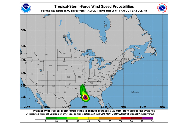
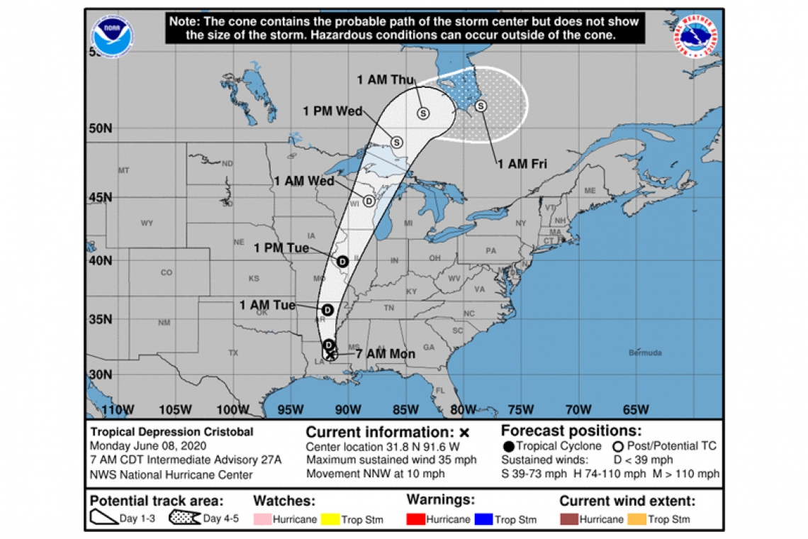
At 700 AM CDT (1200 UTC), the center of Tropical Depression Cristobal was located near latitude 31.8 North, longitude 91.6 West. The depression is moving toward the north-northwest near 10 mph (17 km/h) and this motion should continue today. A turn toward the north is expected tonight, followed by a faster north-northeast motion Tuesday and Wednesday. On the forecast track, the center of Cristobal should move hrough northeastern Louisiana today, through Arkansas and eastern Missouri tonight and Tuesday, and reach Wisconsin and the western Great Lakes by Wednesday.
Maximum sustained winds are 35 mph (55 km/h) with higher gusts. Some weakening is expected through Tuesday. However, Cristobal is expected to strengthen some as it becomes an extratropical low Tuesday night and Wednesday.
The estimated minimum central pressure based on surface observations is 994 mb (29.36 inches).
HAZARDS AFFECTING LAND
----------------------
STORM SURGE: Water levels remain elevated along the Gulf coast and will begin to subside after the next high tide cycle.
WIND: Wind gusts to tropical-storm force are expected to continue during the next few hours over portions of the northern Gulf coast from southeastern Louisiana to the western Florida Panhandle. Gusty winds could also occur Tuesday night and Wednesday over portions of the Midwest and western Great Lakes as Cristobal becomes an extratropical low.
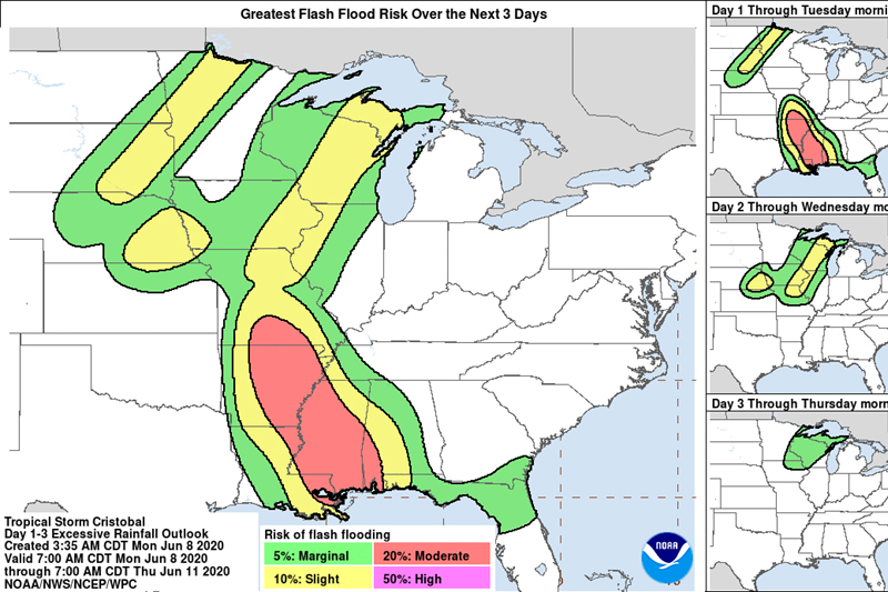
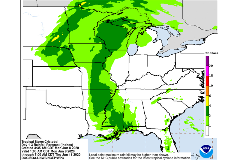
RAINFALL: Cristobal is expected to produce storm total rainfall accumulations of 5 to 10 inches across portions of the central to eastern Gulf Coast into the Lower Mississippi Valley, with isolated amounts to 15 inches. Rainfall totals of 2 to 4 inches with local amounts to 6 inches are expected across portions of the Mid to Upper Mississippi Valley and Northern Plains near and in advance of Cristobal. This rainfall has led to flash flooding and forecast widespread river flooding across portions of the central Gulf Coast into the Lower Mississippi Valley. Smaller streams across southeast LA and southern MS have begun to rise and are forecast to crest mid-week. New and renewed significant river flooding is possible across the mid and upper Mississippi Valley.
TORNADOES: Isolated tornadoes are possible today and tonight acrossMississippi, Alabama, southeastern Louisiana, eastern Arkansas, western Tennessee, and southeastern Missouri.
SURF: Swells generated by Cristobal are still affecting portions of the northern and eastern Gulf coast, and are likely causing life-threatening surf and rip current conditions.