...STORM SURGE AND TROPICAL STORM WARNINGS ISSUED FOR THE NORTHERN GULF COAST...
NWS National Hurricane Center Miami FL AL032020
400 PM CDT Fri Jun 05 2020
SUMMARY OF 400 PM CDT...2100 UTC...INFORMATION
----------------------------------------------
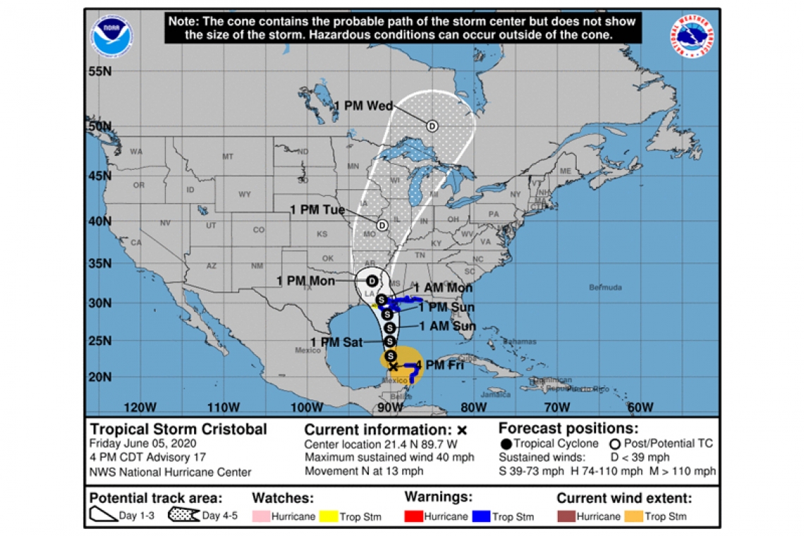
LOCATION...21.4N 89.7W
ABOUT 535 MI...860 KM S OF THE MOUTH OF THE MISSISSIPPI RIVER
MAXIMUM SUSTAINED WINDS...40 MPH...65 KM/H
PRESENT MOVEMENT...N OR 10 DEGREES AT 13 MPH...20 KM/H
MINIMUM CENTRAL PRESSURE...1000 MB...29.53 INCHES
WATCHES AND WARNINGS
--------------------
CHANGES WITH THIS ADVISORY:
A Storm Surge Warning has been issued for areas outside the Hurricane and Storm Damage Risk Reduction System from the mouth of the Mississippi River to Ocean Springs Mississippi, including Lake Borgne.
A Tropical Storm Warning has been issued for the northern Gulf of Mexico coast from east of Morgan City, Louisiana to the Okaloosa/Walton County Florida line.
The Storm Surge Watch has been extended west of Grand Isle to east of Morgan City Louisiana.
SUMMARY OF WATCHES AND WARNINGS IN EFFECT:
A Storm Surge Warning is in effect for...
* Mouth of the Mississippi River to Ocean Springs Mississippi
* Lake Borgne
A Storm Surge Watch is in effect for...
* Indian Pass to Arepika Florida
* East of Morgan City Louisiana to the mouth of the Mississippi River
A Tropical Storm Warning is in effect for
* Punta Herrero to Rio Lagartos Mexico
* East of Morgan City, Louisiana to the Okaloosa/Walton County Florida line
* Lake Pontchartrain and Lake Maurepas
A Tropical Storm Watch is in effect for...
* Intracoastal City Louisiana to Morgan City
A Storm Surge Warning means there is a danger of life-threatening inundation, from rising water moving inland from the coastline, during the next 36 hours in the indicated locations. This is a life-threatening situation. Persons located within these areas should take all necessary actions to protect life and property from rising water and the potential for other dangerous conditions. Promptly follow evacuation and other instructions from local officials.
A Storm Surge Watch means there is a possibility of life-threatening inundation, from rising water moving inland from the coastline, in the indicated locations during the next 48 hours.
A Tropical Storm Warning means that tropical storm conditions are expected somewhere within the warning area within the next 36 hours.
A Tropical Storm Watch means that tropical storm conditions are possible within the watch area, generally within 48 hours.
DISCUSSION AND OUTLOOK
----------------------
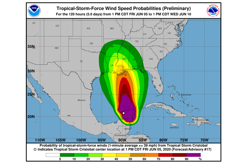
At 400 PM CDT (2100 UTC), the center of Tropical Storm Cristobal was located near latitude 21.4 North, longitude 89.7 West. Cristobal is moving toward the north near 13 mph (20 km/h), and this general motion is expected to continue for the next couple of days. On the forecast track, the center of Cristobal will move over the central Gulf of Mexico on Saturday, and be near the northern Gulf of Mexico coast on Sunday. Cristobal's center is then forecast to move inland across Louisiana late Sunday and Monday.
Maximum sustained winds are near 40 mph (65 km/h) with higher gusts. Some strengthening is forecast during the next 48 hours. Weakening will begin once Cristobal moves inland late Sunday and Monday.
Tropical-storm-force winds extend outward up to 240 miles (390 km) from the center.
The estimated minimum central pressure is 1000 mb (29.53 inches).
HAZARDS AFFECTING LAND
----------------------
STORM SURGE: The combination of a dangerous storm surge and the tide will cause normally dry areas near the coast to be flooded by rising waters moving inland from the shoreline. The water could reach the following heights above ground somewhere in the indicated areas if the peak surge occurs at the time of high tide...
Mouth of the Mississippi River to Ocean Springs MS including Lake Borgne...3-5 ft
Ocean Springs MS to Indian Pass FL including Mobile Bay and Pensacola Bay...1-3 ft
Indian Pass FL to Aripeka FL...2-4 ft
Aripeka FL to Marco Island FL including Tampa Bay...1-3 ft
Morgan City LA to the Mouth of the Mississippi River...2-4 ft
The deepest water will occur along the immediate coast in areas of onshore winds and will likely extend along the coast well to the east of the center. Surge-related flooding depends on the relative timing of the surge and the tidal cycle, and can vary greatly over short distances. For information specific to your area, please see products issued by your local National Weather Service forecast
office.
WIND: Tropical storm conditions are expected to continue in portions of the Tropical Storm Warning area along the Yucatan Peninsula during the next few hours. Tropical storm conditions are expected within the Tropical Storm Warning area along the northern Gulf Coast beginning late Saturday night. Tropical storm conditions are possible within the watch area on Sunday.
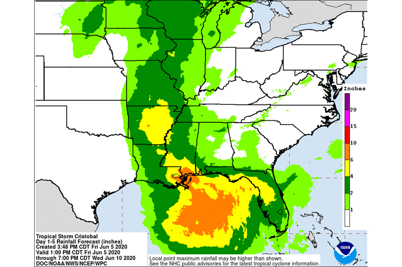
RAINFALL: Cristobal is expected to produce the following rain accumulations:
Through Wednesday morning, for portions of the eastern and central Gulf Coast and the lower Mississippi Valley, rainfall accumulations of 4 to 8 inches, with local amounts to 12 inches, are forecast. Isolated significant river flooding is possible along the central Gulf Coast. Farther north across the mid-Mississippi Valley, rainfall totals of 2 to 4 inches, with local amounts to 6 inches, are expected. This degree of rainfall is expected to lead to flash flooding, and widespread flooding on smaller streams is possible across the mid-Mississippi Valley.
Mexican states of Campeche, Quintana Roo, and Yucatan...Additional 4 to 6 inches, isolated storm totals of 25 inches.
Belize and the Mexican states of Tabasco and Oaxaca...Additional 4 to 6 inches, isolated storm totals of 12 inches.
Southern Guatemala, coastal portions of Chiapas, and El Salvador...Additional 4 to 6 inches, isolated storm total amounts of 35 inches dating back to Saturday, May 30th.
Southern parts of Honduras...Additional 3 to 4 inches, isolated 8 inches.
Rainfall across Southeast Mexico and northern Central America would continue the risk of life-threatening flash floods and mudslides.