
Hurricane Beryl Intermediate Advisory Number 7A...Corrected
NWS National Hurricane Center Miami FL AL022024
800 AM AST Sun Jun 30 2024
SUMMARY OF 800 AM AST...1200 UTC...INFORMATION
----------------------------------------------
LOCATION...10.6N 53.9W
ABOUT 420 MI...675 KM ESE OF BARBADOS
MAXIMUM SUSTAINED WINDS...115 MPH...185 KM/H
PRESENT MOVEMENT...W OR 280 DEGREES AT 21 MPH...33 KM/H
MINIMUM CENTRAL PRESSURE...968 MB...28.58 INCHES
WATCHES AND WARNINGS
--------------------
CHANGES WITH THIS ADVISORY:
The government of Trinidad has upgraded the Tropical Storm Warning to a Hurricane Warning for Tobago.
SUMMARY OF WATCHES AND WARNINGS IN EFFECT:
A Hurricane Warning is in effect for...
* Barbados
* St. Lucia
* St. Vincent and the Grenadine Islands
* Grenada
* Tobago
A Tropical Storm Warning is in effect for...
* Martinique
A Tropical Storm Watch is in effect for...
* Dominica
A Hurricane Warning means that hurricane conditions are expected somewhere within the warning area. Preparations to protect life and property should be rushed to completion.
A Tropical Storm Warning means that tropical storm conditions are expected somewhere within the warning area within 36 hours.
A Tropical Storm Watch means that tropical storm conditions are possible within the watch area, generally within 48 hours.
Interests elsewhere in the Lesser Antilles should closely monitor the progress of Beryl. Additional watches and warnings may be required later today.
For storm information specific to your area, please monitor products issued by your national meteorological service.
DISCUSSION AND OUTLOOK
----------------------
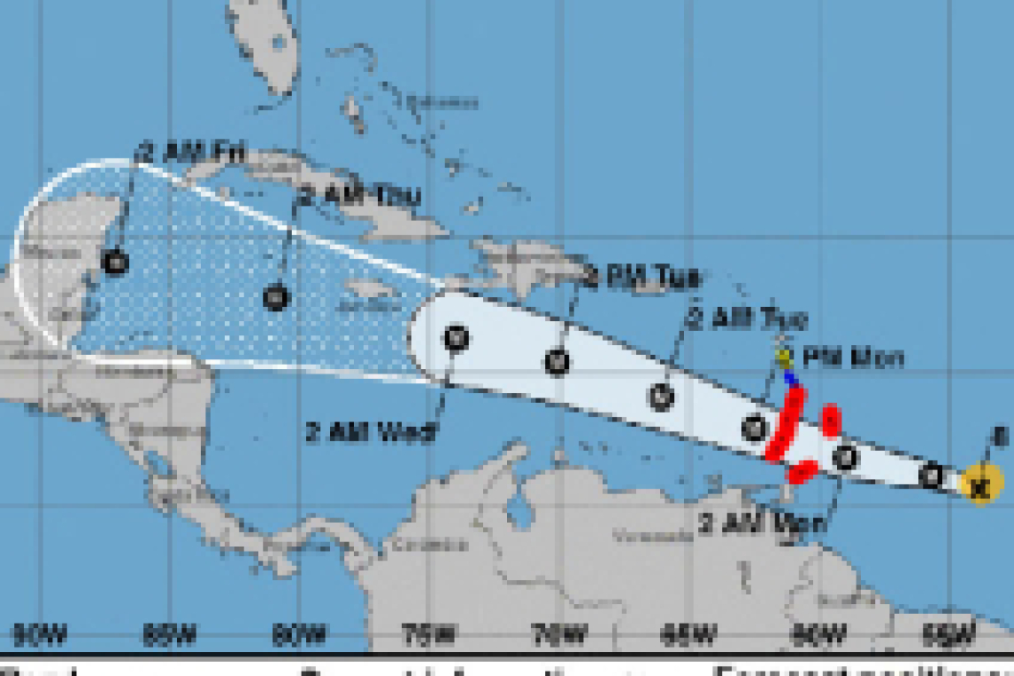
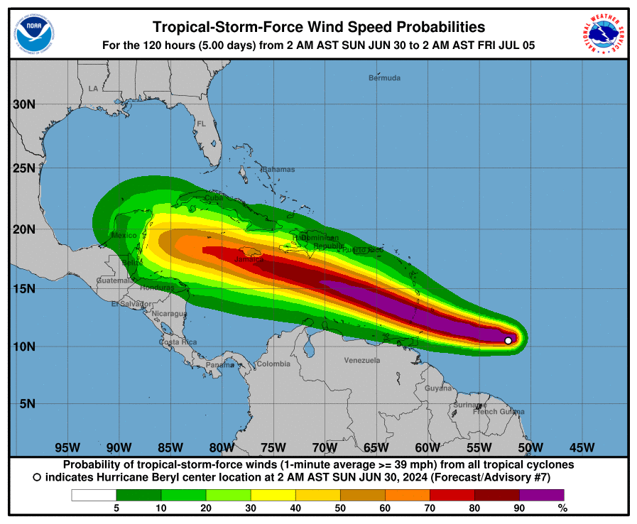
At 800 AM AST (1200 UTC), the eye of Hurricane Beryl was located near latitude 10.6 North, longitude 53.9 West. Beryl is moving toward the west near 21 mph (33 km/h). A continued quick westward to west-northwestward motion is expected during the next few days. On the forecast track, the center of Beryl is expected to move across the Windward Islands early on Monday and across the southeastern Caribbean Sea Monday night and Tuesday.
Aircraft data indicate that the maximum sustained winds have increased to near 115 mph (185 km/h) with higher gusts, making Beryl a very dangerous category 3 hurricane. Continued rapid strengthening is forecast over the next day or so, and Beryl is expected to become an extremely dangerous category 4 hurricane before it reaches the Windward Islands.
Hurricane-force winds extend outward up to 15 miles (30 km) from the center and tropical-storm-force winds extend outward up to 80 miles (130 km).
The minimum central pressure based on data from the Air Force Hurricane Hunters is 968 mb (28.58 inches).
HAZARDS AFFECTING LAND
----------------------
WIND: Hurricane conditions are expected in the hurricane warning area beginning early on Monday. Devastating wind damage is expected where the eyewall of Beryl moves through portions of the Windward Islands.
Tropical storm conditions are expected in the tropical storm warning area starting late tonight, making outside preparations difficult or dangerous.
Tropical storm conditions are possible within the watch area starting late tonight.
Wind speeds atop and on the windward sides of hills and mountains are often up to 30 percent stronger than the near-surface winds indicated in this advisory, and in some elevated locations could be even greater.
STORM SURGE: A life-threatening storm surge will raise water levels by as much as 6 to 9 feet above normal tide levels in areas of onshore flow near where Beryl makes landfall in the hurricane warning area. Near the coast, the surge will be accompanied by large and destructive waves.
RAINIFA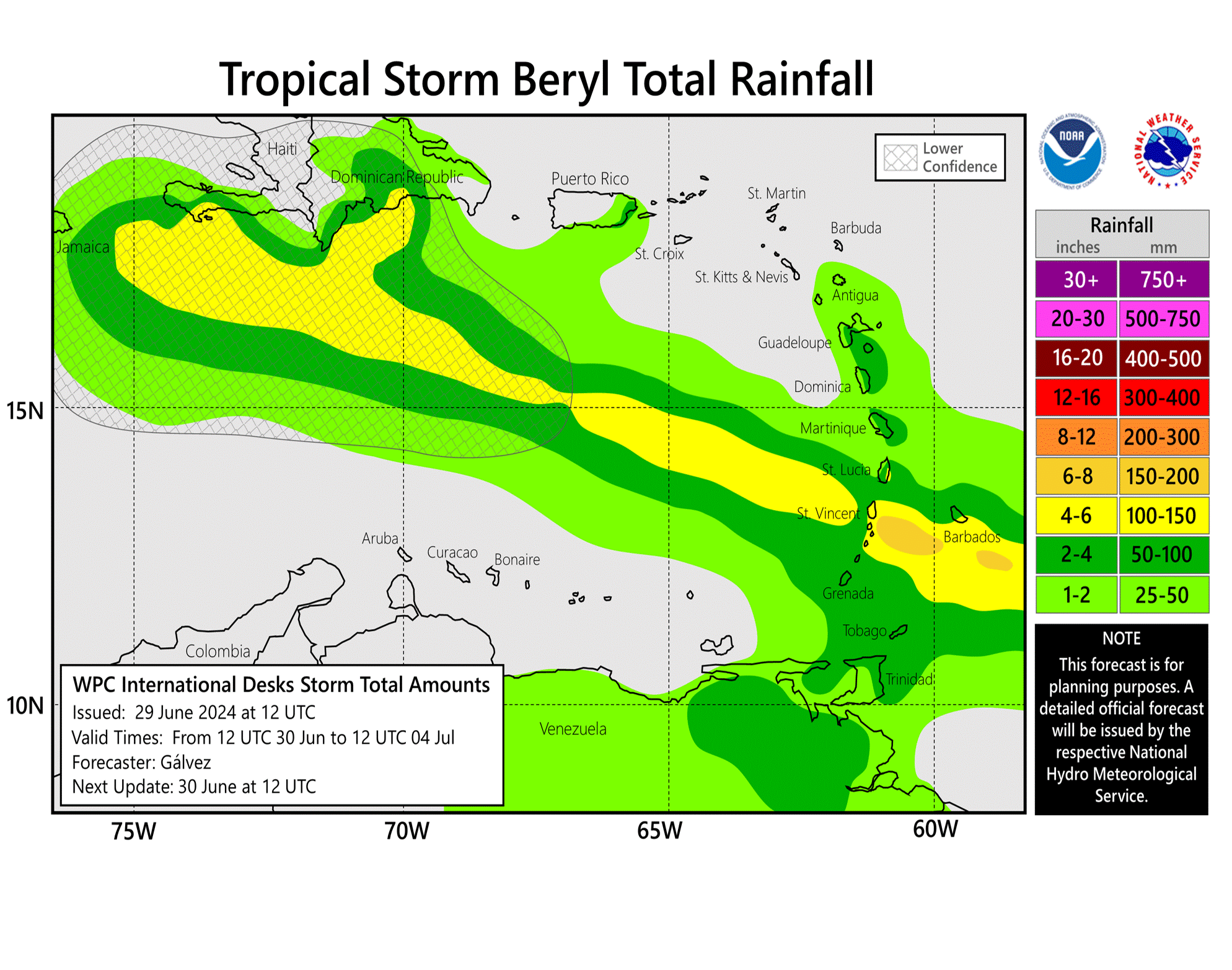 RAINFALL: Hurricane Beryl is expected to produce rainfall totals of 3 to 6 inches across Barbados and the Windward Islands tonight and Monday. This rainfall may cause flash flooding in vulnerable areas.
SURF: Large swells generated by Beryl are expected across Windward and southern Leeward Islands during the next couple of days. These swells are expected to cause life-threatening surf and rip current conditions. Please consult products from your local weather office.
Forecaster Cangialos


