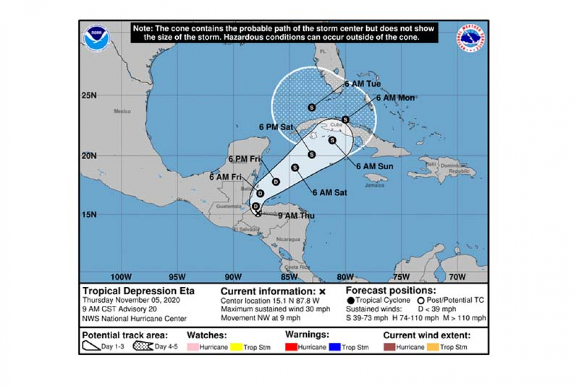
...EXPECTED TO MOVE OVER THE CARIBBEAN SEA ON FRIDAY...
Tropical Depression Eta Advisory Number 20
NWS National Hurricane Center Miami FL AL292020
900 AM CST Thu Nov 05 2020
SUMMARY OF 900 AM CST...1500 UTC...INFORMATION
----------------------------------------------
LOCATION...15.1N 87.8W
ABOUT 80 MI...130 KM SW OF LA CEIBA HONDURAS
MAXIMUM SUSTAINED WINDS...30 MPH...45 KM/H
PRESENT MOVEMENT...NW OR 305 DEGREES AT 9 MPH...15 KM/H
MINIMUM CENTRAL PRESSURE...1005 MB...29.68 INCHES
WATCHES AND WARNINGS
--------------------
There are no coastal watches or warnings in effect.
The governments of Nicaragua and Honduras continue to issue warnings on heavy rain and flooding in those countries, and interests in Nicaragua and Honduras should continue to monitor the progress of this system. Interests in Belize, western Cuba, and the Cayman Islands should also monitor the progress of this system, as Tropical Storm watches may be required later today or tonight for portions of these areas.
DISCUSSION AND OUTLOOK
----------------------
At 900 AM CST (1500 UTC), the center of Tropical Depression Eta was located near latitude 15.1 North, longitude 87.8 West. The depression is moving toward the northwest near 9 mph (15 km/h), and this general motion is expected to continue today. A turn toward the north, and then the northeast is forecast to occur tonight and Friday. On the forecast track, the center of Eta is expected to move across northwestern Honduras through this afternoon, and emerge over the Gulf of Honduras by tonight. Eta is forecast to approach the Cayman Islands and western or central Cuba this weekend.
Maximum sustained winds are near 30 mph (45 km/h) with higher gusts. Little change in strength is likely through tonight. After that, Eta is forecast to intensify over the northwestern Caribbean Sea.
The estimated minimum central pressure is 1005 mb (29.68 inches).
HAZARDS AFFECTING LAND
----------------------
RAINFALL: Eta is expected to produce the following rainfall amounts through Tuesday morning:
Portions of Central America: An additional 10 to 15 inches (255 to 380 mm), isolated maximum storm totals of 40 inches (1000 mm) in eastern Honduras and eastern Nicaragua.
Southeastern Mexico: 5 to 10 inches (125 to 255 mm), isolated maximum totals of 20 inches (510 mm).
Jamaica: An additional 3 to 5 inches (75 to 125 mm), isolated maximum storm totals of 15 inches (380 mm).
The Cayman Islands into portions of Cuba: 10 to 20 inches (255 to 510 mm), isolated maximum totals of 30 inches (760 mm).
This rainfall will lead to catastrophic, life-threatening flash flooding and river flooding, along with landslides in areas of higher terrain of Central America. Significant, life-threatening flash flooding and river flooding is possible in the Cayman Islands and Cuba. Flash flooding and river flooding is expected for Jamaica and southeast Mexico.
SURF: Swells generated by Eta are expected to affect portions of the coast of Central America and the Yucatan Peninsula of Mexico during the next couple of days. These swells are likely to cause life-threatening surf and rip current conditions. Please consult products from your local weather office.
Forecaster Beven


