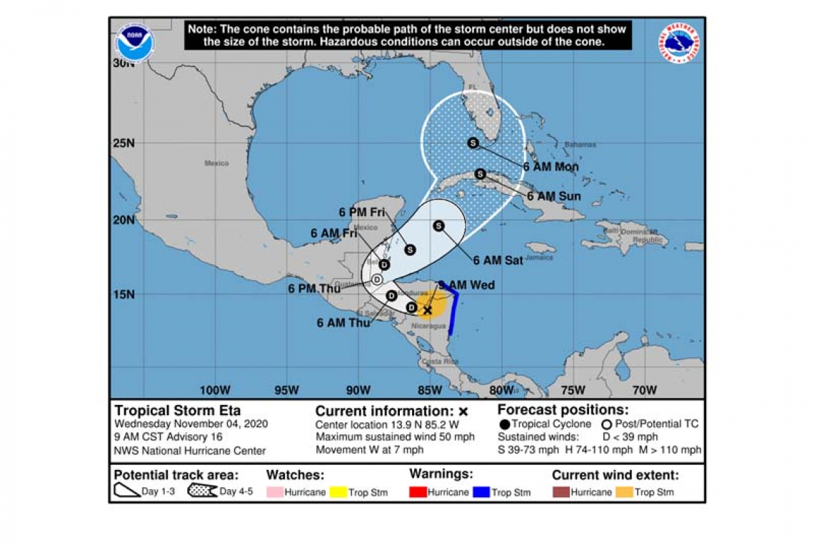
Tropical Storm Eta Advisory Number 16
NWS National Hurricane Center Miami FL AL292020
900 AM CST Wed Nov 04 2020
SUMMARY OF 900 AM CST...1500 UTC...INFORMATION
----------------------------------------------
LOCATION...13.9N 85.2W
ABOUT 135 MI...215 KM NNE OF MANAGUA NICARAGUA
MAXIMUM SUSTAINED WINDS...50 MPH...85 KM/H
PRESENT MOVEMENT...W OR 275 DEGREES AT 7 MPH...11 KM/H
MINIMUM CENTRAL PRESSURE...996 MB...29.42 INCHES
WATCHES AND WARNINGS
--------------------
CHANGES WITH THIS ADVISORY:
None.
SUMMARY OF WATCHES AND WARNINGS IN EFFECT:
A Tropical Storm Warning is in effect for...
* The northeastern coast of Honduras from Punta Patuca to the Honduras/Nicaragua border
* The coast of Nicaragua from the Honduras/Nicaragua border to Laguna de Perlas.
Interests elsewhere in Nicaragua and Honduras should monitor the progress of this system.
For storm information specific to your area, please monitor products issued by your national meteorological service.
DISCUSSION AND OUTLOOK
----------------------
At 900 AM CST (1500 UTC), the center of Tropical Storm Eta was located near latitude 13.9 North, longitude 85.2 West. Eta is moving toward the west near 7 mph (11 km/h). A west-northwestward motion at a faster forward speed is expected later today through Thursday morning. A turn toward the north, and then northeast is forecast Thursday night and Friday. On the forecast track, the center of Eta is expected to move over northern Nicaragua through early this afternoon, and then move across the central portions of Honduras through Thursday morning. The system is forecast to emerge over the Gulf of Honduras or the northwestern Caribbean Sea Thursday night and Friday.
Maximum sustained winds are near 50 mph (85 km/h) with higher gusts. Continued weakening will occur while Eta moves over land during the next couple of days, and Eta should become a tropical depression tonight.
Tropical-storm-force winds extend outward up to 115 miles (185 km)
mainly to the east of the center.
The estimated minimum central pressure is 996 mb (29.42 inches).
HAZARDS AFFECTING LAND
----------------------
WIND: Tropical storm conditions are expected in the warning area for a few more hours, and near the center of Eta for several more hours.
RAINFALL: Eta is expected to produce the following rainfall amounts through Sunday morning:
Much of Nicaragua and Honduras: An additional 10 to 20 inches (255 to 510 mm), isolated maximum totals of 40 inches (1000 mm) in northeast Nicaragua and eastern Honduras.
Eastern Guatemala and Belize: 15 to 25 inches (380 to 635 mm), isolated amounts of 30 inches (760 mm).
Portions of Panama and Costa Rica: 10 to 15 inches (255 to 380 mm), isolated amounts of 25 inches (635 mm).
El Salvador and southeast Mexico: 5 to 10 inches (125 to 255 mm), isolated amounts of 15 inches (380 mm)
The Cayman Islands: An additional 5 to 15 inches (125 to 380 mm), isolated storm totals of 20 inches (510 mm).
Jamaica and Southern Haiti: An additional 3 to 5 inches (75 to 125 mm), isolated storm totals of 15 inches (380 mm).
This rainfall will lead to catastrophic, life-threatening flash flooding and river flooding, along with landslides in areas of higher terrain of Central America. Flash flooding and river
flooding will be possible across Jamaica, southeast Mexico, El Salvador, southern Haiti, and the Cayman Islands.
STORM SURGE: Water levels along the coasts of Nicaragua and Honduras should gradually decrease today.
SURF: Swells generated by Eta are expected to affect portions of the coast of Central America and the Yucatan Peninsula of Mexico during the next few days. These swells are likely to cause life-threatening surf and rip current conditions. Please consult products from your local weather office.
Forecaster Beven


