Tropical Storm Laura Intermediate Advisory Number 18A
NWS National Hurricane Center Miami FL AL132020
800 AM EDT Mon Aug 24 2020
SUMMARY OF 800 AM EDT...1200 UTC...INFORMATION
----------------------------------------------
LOCATION...20.9N 79.7W
ABOUT 125 MI...200 KM ESE OF CAYO LARGO
ABOUT 205 MI...330 KM ESE OF THE ISLE OF YOUTH
MAXIMUM SUSTAINED WINDS...65 MPH...100 KM/H
PRESENT MOVEMENT...WNW OR 290 DEGREES AT 21 MPH...33 KM/H
MINIMUM CENTRAL PRESSURE...1000 MB...29.53 INCHES

WATCHES AND WARNINGS
--------------------
CHANGES WITH THIS ADVISORY:
None
SUMMARY OF WATCHES AND WARNINGS IN EFFECT:
A Tropical Storm Warning is in effect for...
* Little Cayman and Cayman Brac
* Cuban provinces of Camaguey, Las Tunas, Holguin, Guantanamo, Santiago de Cuba, Granma, Ciego De Avila, Sancti Spiritus, Villa Clara, Cienfuegos, Matanzas, Mayabeque, La Habana, Artemisa, Pinar del Rio, and the Isle of Youth
* Florida Keys from Craig Key to Key West
* Dry Tortugas
The Tropical Storm Warning means that tropical storm conditions are expected somewhere within the warning area, in this case within the next 12 to 24 hours.

Hurricane and Storm Surge Watches will likely be required for portions of the U.S. northwest Gulf coast area by this evening.
DISCUSSION AND OUTLOOK
----------------------
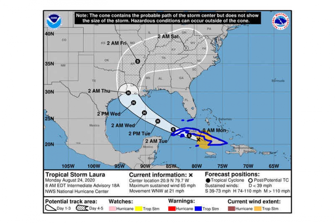
At 800 AM EDT (1200 UTC), the center of Tropical Storm Laura was located near latitude 20.9 North, longitude 79.7 West. Laura is moving toward the west-northwest near 21 mph (33 km/h), and this general motion with some decrease in forward speed is expected over the next couple of days. A turn toward the northwest is forecast by Wednesday. On the forecast track, the center of Laura will move over the Caribbean Sea just offshore the southern coast of Cuba today, and move into the southeastern Gulf of Mexico by early Tuesday morning. Laura is then forecast to move over the central and northwestern Gulf of Mexico Tuesday night and Wednesday.
Maximum sustained winds are near 65 mph (100 km/h) with higher gusts. Gradual strengthening is expected, and Laura is forecast to become a hurricane by early Tuesday.
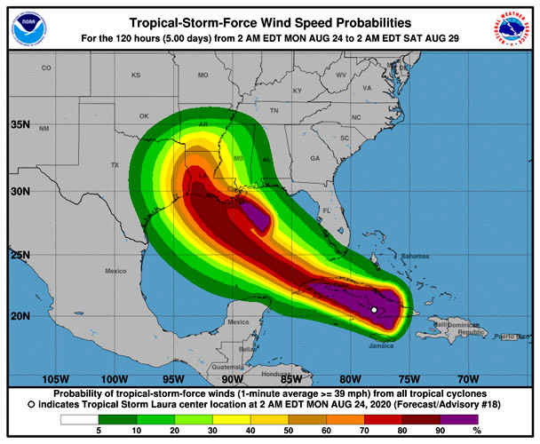
Tropical-storm-force winds extend outward up to 175 miles (280 km) from the center.
The estimated minimum central pressure is 1000 mb (29.53 inches).

HAZARDS AFFECTING LAND
----------------------
RAINFALL: Laura is expected to produce the following storm total rainfall accumulations through Tuesday:
Jamaica and Cuba: 4 to 8 inches, with maximum amounts of 12 inches.
Cayman Islands: 2 to 4 inches, maximum amounts of 6 inches.
Florida Keys, Turks and Caicos Islands, and the Northwest Bahamas: 1 to 2 inches.
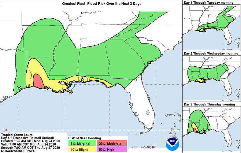
Across the Greater Antilles this heavy rainfall could lead to life-threatening flash and urban flooding, and the potential for mudslides.
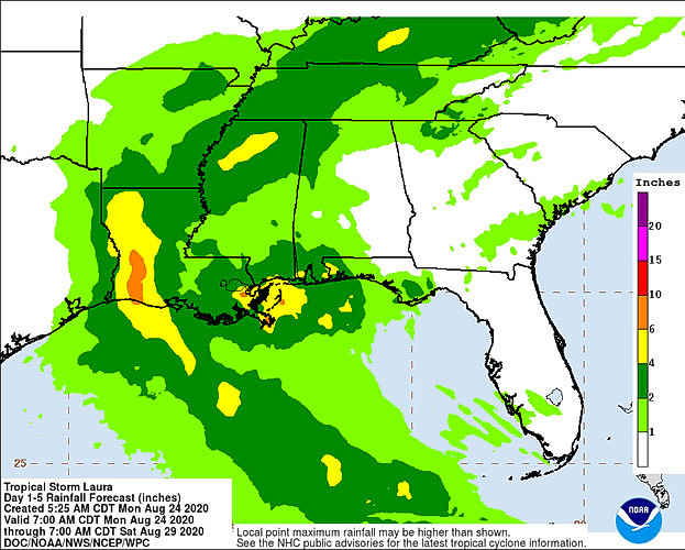
From late Wednesday into Friday, Laura is expected to produce ainfall of 5 to 10 inches, with isolated maximum amounts of 15 inches across portions of the west-central U.S. Gulf Coast near the Texas and Louisiana border north into portions of the lower Mississippi Valley. This rainfall could cause widespread flash and urban flooding, small streams to overflow their banks, and the possibility of some minor river flooding across this region.
WIND: Tropical storm conditions are expected to spread westward within the warning area in Cuba through today. Tropical storm conditions are expected in Little Cayman and Cayman Brac today. Tropical storm conditions are also expected within the warning area in the middle and lower Florida Keys and the Dry Tortugas this afternoon and tonight.
SURF: Swells generated by Laura are affecting portions of Hispaniola, eastern Cuba, the southeastern Bahamas and the Turks and Caicos Islands. These swells are expected to spread across central an western Cuba, the central and northwestern Bahamas, and the Florida Keys today. Please consult products from your local weather office.
TORNADOES: An isolated tornado will be possible later today into tonight across the Florida Keys.
Forecaster Brown


