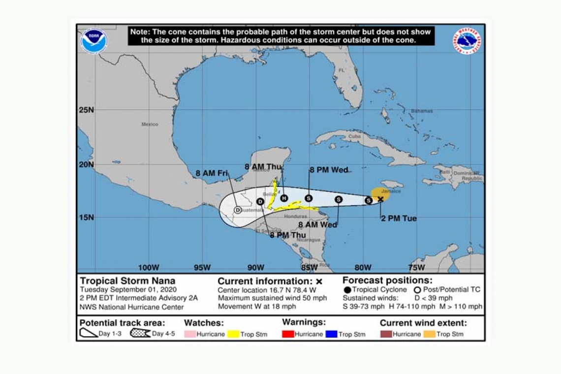
Tropical Storm Nana Intermediate Advisory Number 2A
NWS National Hurricane Center Miami FL AL162020
200 PM EDT Tue Sep 01 2020
SUMMARY OF 200 PM EDT...1800 UTC...INFORMATION
----------------------------------------------
LOCATION...16.7N 78.4W
ABOUT 110 MI...175 KM S OF NEGRIL JAMAICA
ABOUT 650 MI...1045 KM E OF BELIZE CITY
MAXIMUM SUSTAINED WINDS...50 MPH...85 KM/H
PRESENT MOVEMENT...W OR 275 DEGREES AT 18 MPH...30 KM/H
MINIMUM CENTRAL PRESSURE...1002 MB...29.59 INCHES
WATCHES AND WARNINGS
--------------------
CHANGES WITH THIS ADVISORY:
None.
SUMMARY OF WATCHES AND WARNINGS IN EFFECT:
A Tropical Storm Watch is in effect for...
* Northern Honduras
* Roatan Island and the Bay Islands of Honduras
* Belize
A Tropical Storm Watch may be required for portions of Guatemala and the southern Yucatan Peninsula, along with a Hurricane Watch for Belize, later today.
A Tropical Storm Watch means that tropical storm conditions are possible within the watch area, generally within 48 hours.
For storm information specific to your area, please monitor products issued by your national meteorological service.
DISCUSSION AND OUTLOOK
----------------------
At 200 PM EDT (1800 UTC), the center of Tropical Storm Nana was located near latitude 16.7 North, longitude 78.4 West. Nana is moving toward the west near 18 mph (30 km/h), and this general motion is expected to continue through Thursday. On the forecast track, Nana will be moving near but north of the coast of Honduras on Wednesday and likely be approaching the coast of Belize on Thursday.
Maximum sustained winds are near 50 mph (85 km/h) with higher gusts. Additional strengthening is forecast during the next 48 hours, and Nana could become a hurricane just prior to landfall on Thursday.
Tropical-storm-force winds extend outward up to 80 miles (130 km) from the center, mainly northeast through northwest of the center.
The estimated minimum central pressure based on data from the reconnaissance aircraft is 1002 mb (29.59 inches).
HAZARDS AFFECTING LAND
----------------------
WIND: Tropical storm conditions are possible within the watch areas by late Wednesday.
STORM SURGE: A dangerous storm surge will raise water levels by as much as 3 to 5 feet above normal tide levels along the immediate coast near and to the north of where the center makes landfall. Near the coast, the surge will be accompanied by large and destructive waves.
RAINFALL: Nana is expected to produce rainfall accumulations of 2 to 4 inches across northern Honduras, Belize, and the southeast portion of the Mexican state of Quintana Roo.
SURF: Swells generated by this system are affecting portions of the southern coast of Jamaica, and will continue into Wednesday morning. These swells are likely to cause life-threatening surf and rip current conditions. Please consult products from your local weather office.
Forecaster Stewart


