
Tropical Storm Beryl Intermediate Advisory Number 3A
NWS National Hurricane Center Miami FL AL022024
800 AM AST Sat Jun 29 2024
SUMMARY OF 800 AM AST...1200 UTC...INFORMATION
----------------------------------------------
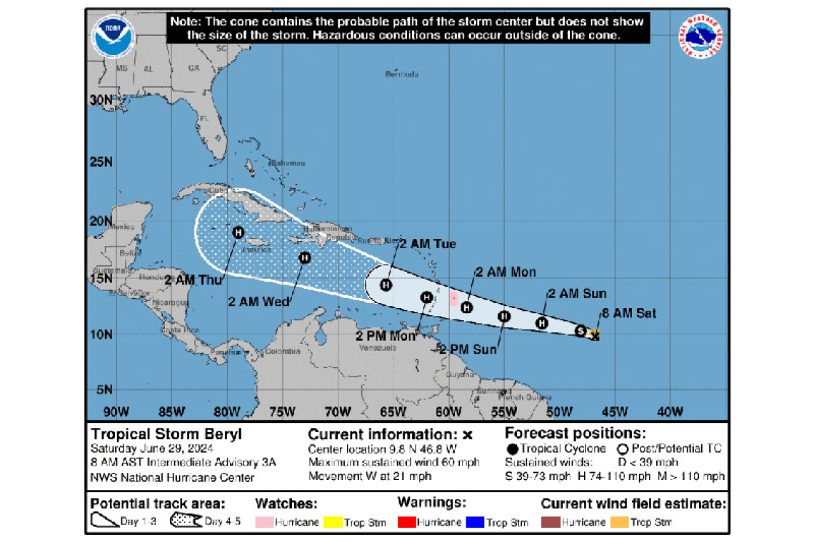
LOCATION...9.8N 46.8W
ABOUT 975 MI...1570 KM ESE OF BARBADOS
MAXIMUM SUSTAINED WINDS...60 MPH...95 KM/H
PRESENT MOVEMENT...W OR 280 DEGREES AT 21 MPH...33 KM/H
MINIMUM CENTRAL PRESSURE...999 MB...29.50 INCHES
WATCHES AND WARNINGS
--------------------
CHANGES WITH THIS ADVISORY:
None
SUMMARY OF WATCHES AND WARNINGS IN EFFECT:
A Hurricane Watch is in effect for...
* Barbados
Interests elsewhere in the Lesser Antilles should closely monitor the progress of Beryl. Additional watches and warnings will likely be required for portions of this area later this morning.
For storm information specific to your area, please monitor products issued by your national meteorological service.
DISCUSSION AND OUTLOOK
----------------------
At 800 AM AST (1200 UTC), the center of Tropical Storm Beryl was located near latitude 9.8 North, longitude 46.8 West. Beryl is moving toward the west near 21 mph (33 km/h). A relatively quick westward to west-northwestward motion is expected during the next few days. On the forecast track, the system is expected to move across the Windward Islands late Sunday night and Monday.
Maximum sustained winds have increased to near 60 mph (95 km/h) with higher gusts. Steady to rapid strengthening is expected during the next couple of days, and Beryl is forecast to become a hurricane tonight or early Sunday with additional strengthening expected after that.
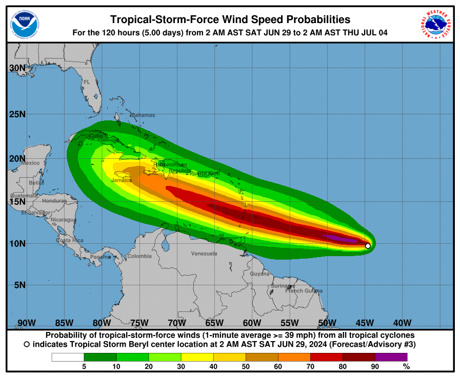
Topical-storm-force winds extend outward up to 45 miles (75 km) from the center.
The estimated minimum central pressure is 999 mb (29.50 inches).
HAZARDS AFFECTING LAND
----------------------
WIND: Hurricane conditions are possible in the hurricane watch area by Sunday night or Monday morning, with tropical storm conditions possible on Sunday.
STORM SURGE: A dangerous storm surge will raise water levels by as much as 2 to 4 feet above normal tide levels in areas of onshore flow in the Hurricane Watch area. Near the coast, the surge will be accompanied by large and destructive waves.
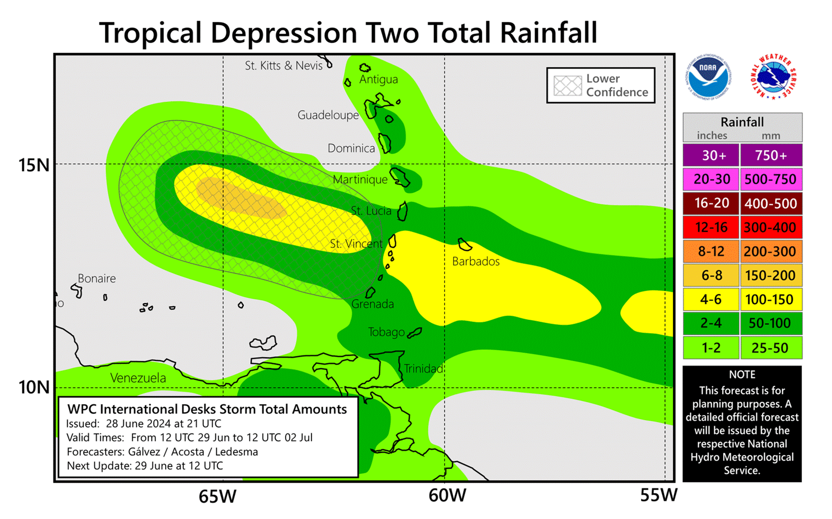
RAINFALL: Tropical Storm Beryl is expected to produce rainfall totals of 3 to 6 inches across Barbados and the Windward Islands.This rainfall may produce localized flooding in vulnerable areas.
SURF: Swells generated by the storm are expected to reach the Windward and southern Leeward Islands by late Sunday. These swells are likely to cause life-threatening surf and rip current conditions. Please consult products from your local weather office.
Forecaster Cangialosi


