...IOTA EXPECTED TO BRING CATASTROPHIC WINDS, LIFE-THREATENING STORM SURGE, AND EXTREME RAINFALL IMPACTS TO CENTRAL AMERICA...
Hurricane Iota Intermediate Advisory Number 12A
NWS National Hurricane Center Miami FL AL312020
700 AM EST Mon Nov 16 2020
SUMMARY OF 700 AM EST...1200 UTC...INFORMATION
----------------------------------------------
LOCATION...13.5N 81.6W
ABOUT 20 MI...35 KM NW OF ISLA DE PROVIDENCIA COLOMBIA
ABOUT 145 MI...235 KM SE OF CABO GRACIAS A DIOS ON NIC/HON BORDER
MAXIMUM SUSTAINED WINDS...155 MPH...245 KM/H
PRESENT MOVEMENT...W OR 275 DEGREES AT 10 MPH...17 KM/H
MINIMUM CENTRAL PRESSURE...925 MB...27.32 INCHES
WATCHES AND WARNINGS
--------------------
CHANGES WITH THIS ADVISORY:
None.
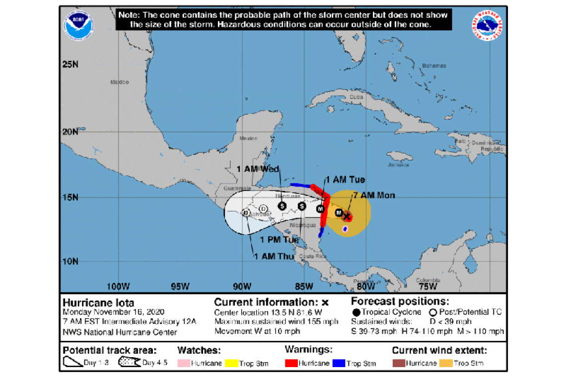
SUMMARY OF WATCHES AND WARNINGS IN EFFECT:
A Hurricane Warning is in effect for...
* Providencia
* The coast of Nicaragua from the Honduras/Nicaragua border to Sandy Bay Sirpi
* The coast of northeastern Honduras from Punta Patuca to the Honduras/Nicaragua border
A Hurricane Watch is in effect for...
* San Andres
A Tropical Storm Warning is in effect for...
* San Andres
* The coast of Nicaragua from south of Sandy Bay Sirpi to Bluefields
* The northern coast of Honduras from west of Punta Patuca to Punta Castilla
A Hurricane Warning means that hurricane conditions are expected somewhere within the warning area. Preparations to protect life and property should be rushed to completion in Nicaragua and Honduras.
A Hurricane Watch means that hurricane conditions are possible within the watch area.
A Tropical Storm Warning means that tropical storm conditions are expected somewhere within the warning area within 36 hours.
Interests elsewhere in Nicaragua and Honduras should monitor the progress of Iota.
For storm information specific to your area, please monitor products issued by your national meteorological service.
DISCUSSION AND OUTLOOK
----------------------
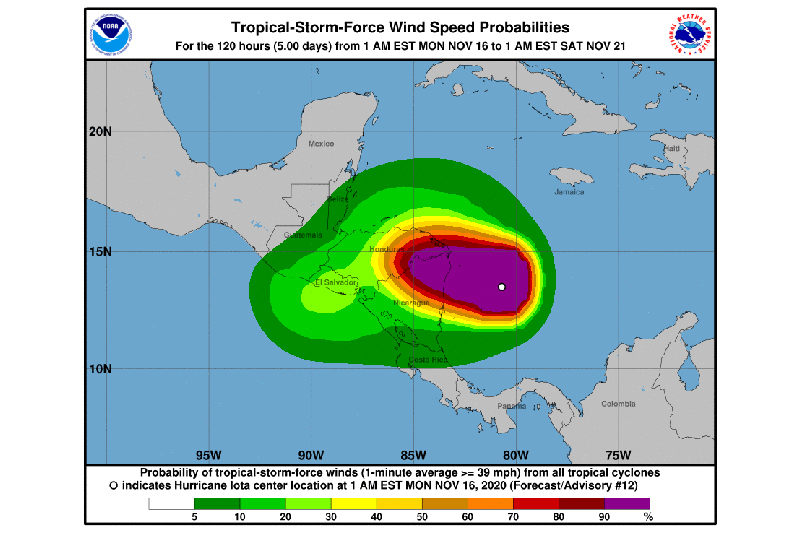
At 700 AM EST (1200 UTC), the center of Hurricane Iota was located by NOAA satellite data near latitude 13.5 North, longitude 81.6 West. Iota is moving toward the west near 10 mph (17 km/h). A westward to west-northwestward motion is forecast through landfall. After landfall, a westward to west-southwestward motion is expected. On the forecast track, the core of Iota will make landfall within the hurricane warning area in northeastern Nicaragua and eastern Honduras tonight, and will dissipate over Central America by midweek.
Data from NOAA satellites indicate that maximum sustained winds have increased to near 155 mph (245 km/h) with higher gusts. Iota is a category 4 hurricane on the Saffir-Simpson Hurricane Wind Scale. Iota could be a catastrophic category 5 hurricane when it approaches Central America tonight, and rapid weakening is expected after landfall.
Hurricane-force winds extend outward up to 35 miles (55 km) from the center and tropical-storm-force winds extend outward up to 150 miles (240 km).
The estimated minimum central pressure is 925 mb (27.32 inches).
HAZARDS AFFECTING LAND
----------------------
STORM SURGE: A life-threatening storm surge will raise water levels by as much as 12 to 18 feet above normal tide levels in areas of onshore winds along the coast of Nicaragua and Honduras. Near the coast, the surge will be accompanied by large and destructive waves.
WIND: Catastrophic wind damage is expected where Iota's eyewall moves onshore within the Hurricane Warning area in Nicaragua and Honduras beginning late tonight with tropical storm conditions expected by late morning. Hurricane conditions are likely occurring on the island of Providencia, with tropical storm conditions expected through the remainder of this morning and possibly into the early afternoon. Tropical storm conditions are likely occurring on the island of San Andres, with hurricane conditions possible there later this morning. Tropical storm conditions are expected in the Tropical Storm Warning area in Nicaragua by late afternoon and in the warning area in Honduras by tonight.
RAINFALL: Iota is expected to produce the following rainfall accumulations through Thursday:
Honduras, northern Nicaragua, Guatemala, southern Belize: 8 to 16 inches (200 to 400 mm). Isolated maximum totals of 20-30 inches (500 to 750 mm) will be possible, especially from northeast Nicaragua into northern Honduras.
Costa Rica and Panama: 4 to 8 inches (100 to 200 mm), with isolated maximum totals of 12 inches (300 mm).
This rainfall will lead to significant, life-threatening flash flooding and river flooding, along with mudslides in areas of higher terrain.
El Salvador and southern Nicaragua: 3 to 5 inches (75 to 125 mm), with isolated maximum totals of 10 inches (250 mm).
SURF: Swells generated by Iota will affect much of the coast of Central America, the Yucatan Peninsula, Jamaica, and Colombia during the next couple of days. These swells are likely to cause life-threatening surf and rip current conditions. Please consult products from your local weather office.


