
...SIGNIFICANT FLOODING LIKELY ACROSS PUERTO RICO AND THE VIRGIN ISLANDS AS HEAVY RAINS PERSIST...
Hurricane Ernesto Advisory Number 12
NWS National Hurricane Center Miami FL AL052024
1100 AM AST Wed Aug 14 2024
SUMMARY OF 1100 AM AST...1500 UTC...INFORMATION
-----------------------------------------------
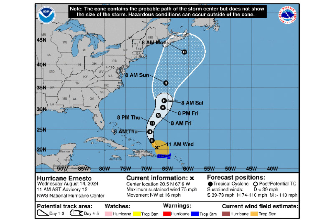
LOCATION...20.5N 67.6W
ABOUT 175 MI...280 KM NW OF SAN JUAN PUERTO RICO
ABOUT 835 MI...1340 KM SSW OF BERMUDA
MAXIMUM SUSTAINED WINDS...75 MPH...120 KM/H
PRESENT MOVEMENT...NW OR 310 DEGREES AT 16 MPH...26 KM/H
MINIMUM CENTRAL PRESSURE...991 MB...29.27 INCHES
WATCHES AND WARNINGS
--------------------
CHANGES WITH THIS ADVISORY:
None.
SUMMARY OF WATCHES AND WARNINGS IN EFFECT:
A Tropical Storm Warning is in effect for...
* British Virgin Islands
* U.S. Virgin Islands
* Puerto Rico
* Vieques and Culebra
A Tropical Storm Warning means that tropical storm conditions are expected somewhere within the warning area.
Interests in Bermuda should monitor the progress of Ernesto. A hurricane watch may be required for the island later today.
For storm information specific to your area in the United States, including possible inland watches and warnings, please monitor products issued by your local National Weather Service forecast office. For storm information specific to your area outside of the United States, please monitor products issued by your national meteorological service.
DISCUSSION AND OUTLOOK
----------------------
At 1100 AM AST (1500 UTC), the center of Hurricane Ernesto was located near latitude 20.5 North, longitude 67.6 West. Ernesto is moving toward the northwest near 16 mph (26 km/h). A turn toward the north-northwest and north is expected later today and tonight, with a generally northward motion at a slower forward speed continuing through Saturday. On the forecast track, the center of Ernesto will continue to move away from Puerto Rico today, move across the western Atlantic during the next few days, and approach Bermuda Friday and Saturday.
Data from Air Force Reserve and NOAA Hurricane Hunter aircraft indicate that maximum sustained winds have increased to near 75 mph (120 km/h) with higher gusts. Additional strengthening is forecast during the next couple of days.
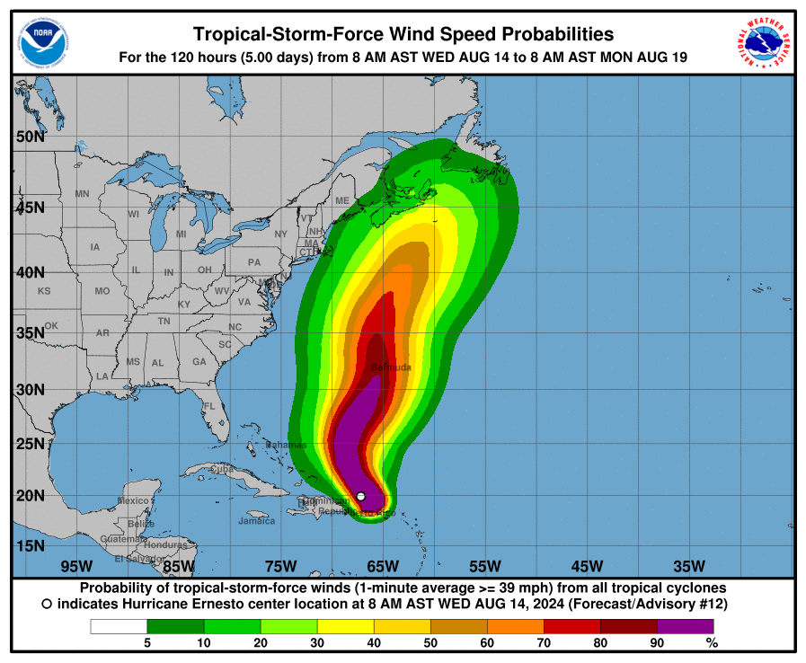
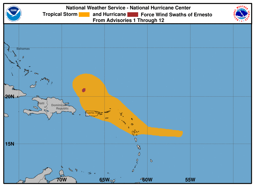
Hurricane-force winds extend outward up to 35 miles (55 km) from the center and tropical-storm-force winds extend outward up to 230 miles (370 km).
The estimated minimum central pressure is 991 mb (29.27 inches).
HAZARDS AFFECTING LAND
----------------------
RAINFALL: Tropical Storm Ernesto is expected to produce total rain accumulations of 4 to 6 inches over the U.S and British Virgin Islands. Rainfall totals of 6 to 8 inches, with maximum amounts of 10 inches, are expected across southeastern Puerto Rico, with totals of 2 to 4 inches across northwestern Puerto Rico.
Rainfall associated with Ernesto may begin to affect Bermuda on Thursday.
WIND: Tropical storm conditions, especially in gusts, will continue across the Virgin Islands, Puerto Rico, Vieques, and Culebra through the day.
SURF: Swells generated by Ernesto are affecting portions of the Leeward Islands, the Virgin Islands, Puerto Rico, the Dominican Republic, and the Turks and Caicos Islands. These swells will reach the southeastern Bahamas today, and Bermuda and the rest of the Bahamas on Thursday. Swells are expected to reach the east coast of the United States Thursday night and continue into the weekend. These swells are likely to cause life-threatening surf and rip current conditions. Please consult products from your local
weather office.
Forecaster Berg


