Tropical Storm Eta Intermediate Advisory Number 3A
NWS National Hurricane Center Miami FL AL292020
700 AM EST Sun Nov 01 2020
SUMMARY OF 700 AM EST...1200 UTC...INFORMATION
----------------------------------------------
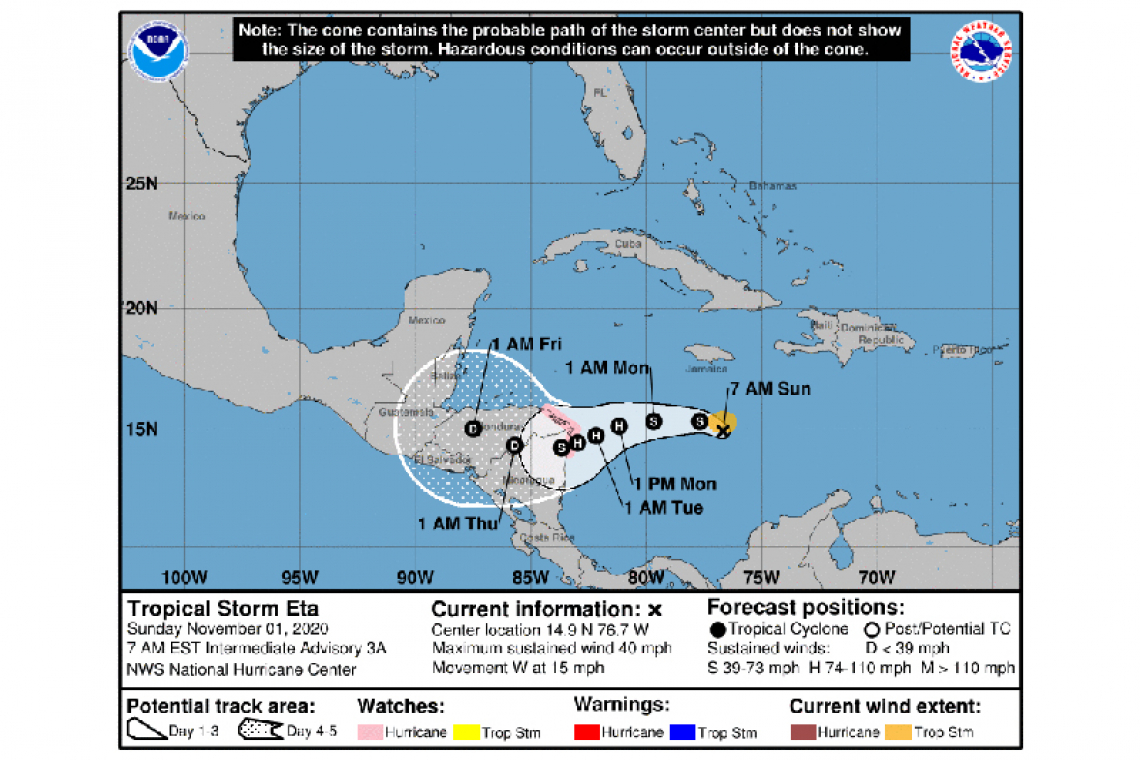
LOCATION...14.9N 76.7W
ABOUT 215 MI...345 KM S OF KINGSTON JAMAICA
ABOUT 435 MI...700 KM E OF CABO GRACIAS A DIOS ON NIC/HON BORDER
MAXIMUM SUSTAINED WINDS...40 MPH...65 KM/H
PRESENT MOVEMENT...W OR 275 DEGREES AT 15 MPH...24 KM/H
MINIMUM CENTRAL PRESSURE...1005 MB...29.68 INCHES
WATCHES AND WARNINGS
--------------------
CHANGES WITH THIS ADVISORY:
None.
SUMMARY OF WATCHES AND WARNINGS IN EFFECT:
A Hurricane Watch is in effect for...
* The northeastern coast of Honduras from Punta Patuca to the Honduras/Nicaragua border.
* The northeastern coast of Nicaragua from the Honduras/Nicaragua border to Puerto Cabezas
A Hurricane Watch means that hurricane conditions are possible within the watch area. A watch is typically issued 48 hours before the anticipated first occurrence of tropical-storm-force winds, conditions that make outside preparations difficult or dangerous.
Interests elsewhere in Nicaragua and Honduras should monitor the progress of this system. Additional watches or warnings will likely be required for portions of these countries later today.
For storm information specific to your area, please monitor products issued by your national meteorological service.
DISCUSSION AND OUTLOOK
----------------------
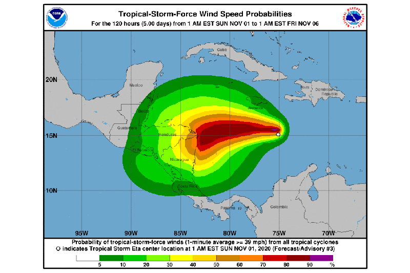
At 700 AM EST (1200 UTC), the center of Tropical Storm Eta was located near latitude 14.9 North, longitude 76.7 West. Eta is moving toward the west near 15 mph (24 km/h), and this motion with some decrease in forward speed is expected to continue today and tonight. A slower motion toward the west-southwest is forecast on Monday and Tuesday. On the forecast track, the center of the cyclone is expected to be near the northeastern coasts of Nicaragua and Honduras by Tuesday morning.
Maximum sustained winds are near 40 mph (65 km/h) with higher gusts. Strengthening is forecast, and Eta is expected to become a hurricane by Monday.
Tropical-storm-force winds extend outward up to 60 miles (95 km) from the center.
The estimated minimum central pressure is 1005 mb (29.68 inches).
HAZARDS AFFECTING LAND
----------------------
WIND: Hurricane conditions are possible in the Hurricane Watch area by early Tuesday, with tropical storm conditions possible in this area by Monday night.
RAINFALL: Through Thursday evening, Eta is expected to produce 5 to 10 inches of rain, with local maximum amounts of 15 inches across Jamaica, the Cayman Islands, and the southern coast of Hispaniola. Across northern Honduras and northern Nicaragua, rainfall totals of 10 to 20 inches, with local maximum amounts of 30 inches are expected. This rainfall may lead to life-threatening flash flooding and river flooding, along with landslides in areas of higher terrain.


