...TROPICAL STORM WARNING ISSUED FOR SOUTH FLORIDA AND THE FLORIDA KEYS...
Tropical Storm Eta Advisory Number 28
NWS National Hurricane Center Miami FL AL292020
1000 AM EST Sat Nov 07 2020
SUMMARY OF 1000 AM EST...1500 UTC...INFORMATION
-----------------------------------------------
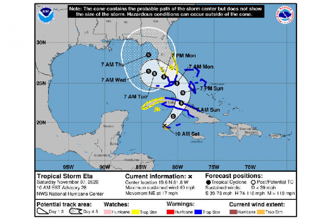
LOCATION...19.6N 81.8W
ABOUT 45 MI...70 KM WNW OF GRAND CAYMAN
ABOUT 280 MI...450 KM WSW OF CAMAGUEY CUBA
MAXIMUM SUSTAINED WINDS...40 MPH...65 KM/H
PRESENT MOVEMENT...NE OR 55 DEGREES AT 17 MPH...28 KM/H
MINIMUM CENTRAL PRESSURE...998 MB...29.47 INCHES
WATCHES AND WARNINGS
--------------------
CHANGES WITH THIS ADVISORY:
A Tropical Storm Warning is in effect for south Florida from Golden Beach to Chokoloskee, including Florida Bay, as well as for the Florida Keys from Ocean Reef to the Dry Tortugas.
A Tropical Storm Watch is now in effect along the Florida east coast north of Sebastien Inlet to the Brevard/Volusia county line.
A Tropical Storm Watch is now in effect for the Florida west coast north of Bonita Beach to Englewood.
SUMMARY OF WATCHES AND WARNINGS IN EFFECT:
A Tropical Storm Warning is in effect for...
* The Cayman Islands
* The Cuban provinces of Camaguey, Ciego de Avila, Sancti Spiritus, Villa Clara, Cienfuegos, and Matanzas.
* Northwestern Bahamas, including the Abacos, Andros Island, Berry Islands, Bimini, Eleuthera, Grand Bahama Island, and New Providence.
* Florida coast from Golden Beach to Chokoloskee, including Florida Bay.
* The Florida Keys from Ocean Reef to the Dry Tortugas.
A Tropical Storm Watch is in effect for...
* The Cuban provinces of La Habana, Artemisa, Mayabeque, Pinar del Rio, and the Isle of Youth.
* Florida east coast north of Golden Beach Florida to the Brevard/Volusia county line.
* Florida west coast north of Chokoloskee to Englewood.
* Lake Okeechobee
A Tropical Storm Warning means that tropical storm conditions are expected somewhere within the warning area within 36 hours.
A Tropical Storm Watch means that tropical storm conditions are possible within the watch area, generally within 48 hours.
Interests elsewhere in Cuba and the Florida peninsula should monitor the progress of this system as additional Tropical Storm Watches or Warnings could be required for some of these areas later today.
DISCUSSION AND OUTLOOK
----------------------
At 1000 AM EST (1500 UTC), the center of Tropical Storm Eta was located near latitude 19.6 North, longitude 81.8 West. Eta is moving toward the northeast near 17 mph (28 km/h). An east-northeast to northeast motion is expected through early Sunday. A turn toward the north and northwest are expected by Sunday afternoon. On the forecast track, the center of Eta will approach the Cayman Islands later today, be near central Cuba tonight and Sunday, and near the Florida Keys or south Florida Sunday night and Monday.
Maximum sustained winds are now near 40 mph (65 km/h) with higher gusts. Additional strengthening is expected through Sunday night.
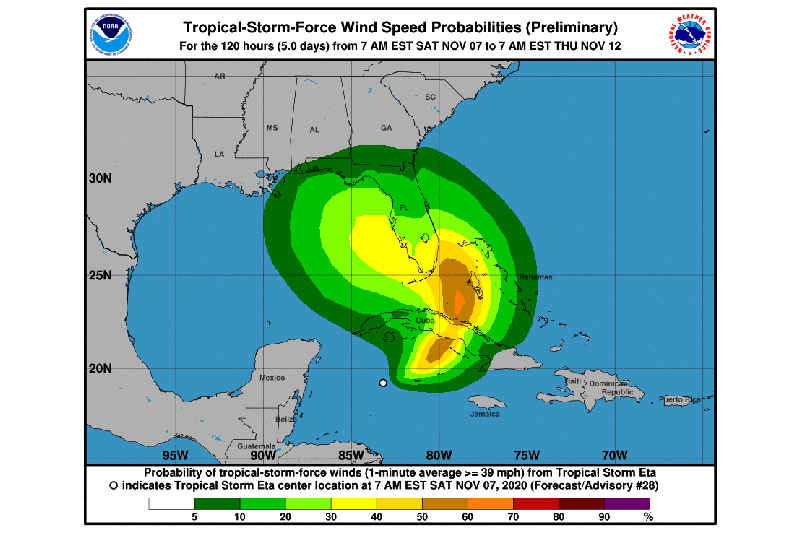
Tropical-storm-force winds extend outward up to 60 miles (95 km) from the center. Grand Cayman Island recently reported estimated sustained winds of 40 mph (65 km/h).
The estimated minimum central pressure based on observations from Grand Cayman Island is 998 mb (29.47 inches).
HAZARDS AFFECTING LAND
----------------------
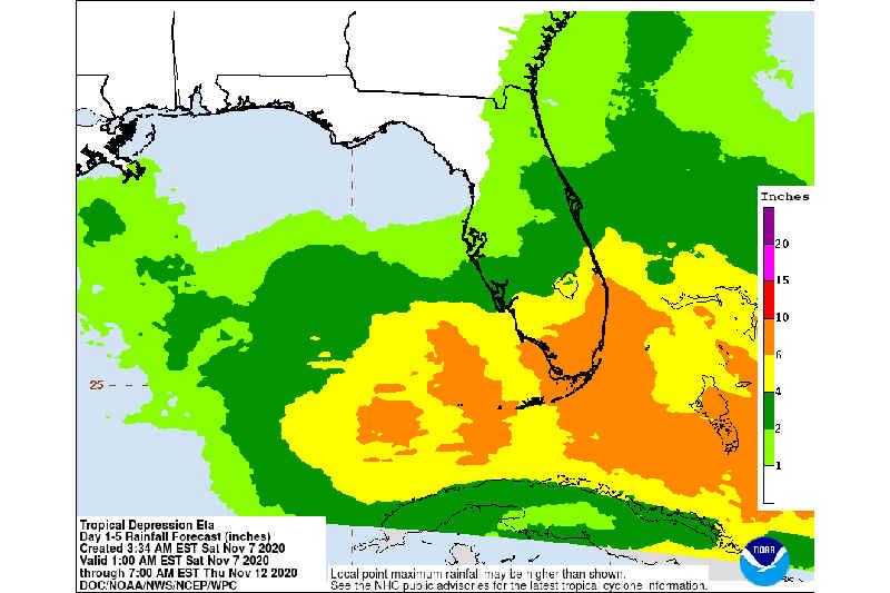
RAINFALL: Eta is expected to produce the following rainfall amounts through Thursday morning:
Jamaica: An additional 2 to 4 inches (50 to 125 mm), isolated maximum storm totals of 15 inches (380 mm).
The Cayman Islands into portions of Cuba: an additional 5 to 10 inches (200 to 400 mm), isolated maximum storm totals of 25 inches (650 mm).
The Bahamas and portions of the central and southern Florida peninsula, including the Keys: 5 to 10 inches (125 to 255 mm), isolated maximum totals of 15 inches (380 mm).
Significant, life-threatening flash and river flooding will be possible in Cuba, along with landslides in areas of higher terrain. Flash and urban flooding will also be possible for the Cayman Islands, Jamaica, the Bahamas, and Southern Florida.
STORM SURGE: A dangerous storm surge will raise water levels by as much as 2 to 4 feet above normal tide levels along the coast of Cuba near and to the east of where the center makes landfall. Near the coast, the surge will be accompanied by large and destructive waves.
The combination of a storm surge and the tide will cause normally dry areas near the coast to be flooded by rising waters moving inland from the shoreline. The water could reach the following heights above ground somewhere in the indicated areas if the peak surge occurs at the time of high tide...
Marco Island, FL to North Miami Beach, FL including Biscayne Bay...2-3 ft
Florida Keys...2-3 ft
Flagler/Volusia County Line, FL to Altamaha Sound, GA...2-3 ft
North Miami Beach, FL to Flagler/Volusia County Line, FL...1-2 ft
The deepest water will occur along the immediate coast in areas of onshore winds, where the surge will be accompanied by large and dangerous waves. Surge-related flooding depends on the relative timing of the surge and the tidal cycle, and can vary greatly over short distances. For information specific to your area, please see products issued by your local National Weather Service forecast office.
WIND: Tropical storm conditions are expected in the Cayman Islands this afternoon and evening, in the warning area sin Cuba tonight and Sunday, in the northwestern Bahamas on Sunday, and in south Florida and the Florida Keys late Sunday and Sunday night. Tropical storm conditions are possible in the watch area in Cuba tonight and Sunday and in the watch area in Florida by late Sunday or early Monday.
TORNADOES: A tornado or two may occur Sunday evening and Sunday night over south Florida and the Keys
SURF: Swells generated by Eta are expected to spread northeastward and affect the Cayman Islands, Jamaica, the southern coast of Cuba, the northwestern Bahamas, and southern Florida and the Florida Keys during the next couple of days. These swells are likely to cause life-threatening surf and rip current conditions. Please consult products from your local weather office.