
Tropical Storm Oscar Intermediate Advisory Number 13A
NWS National Hurricane Center Miami FL AL162024
800 AM EDT Tue Oct 22 2024
SUMMARY OF 800 AM EDT...1200 UTC...INFORMATION
----------------------------------------------
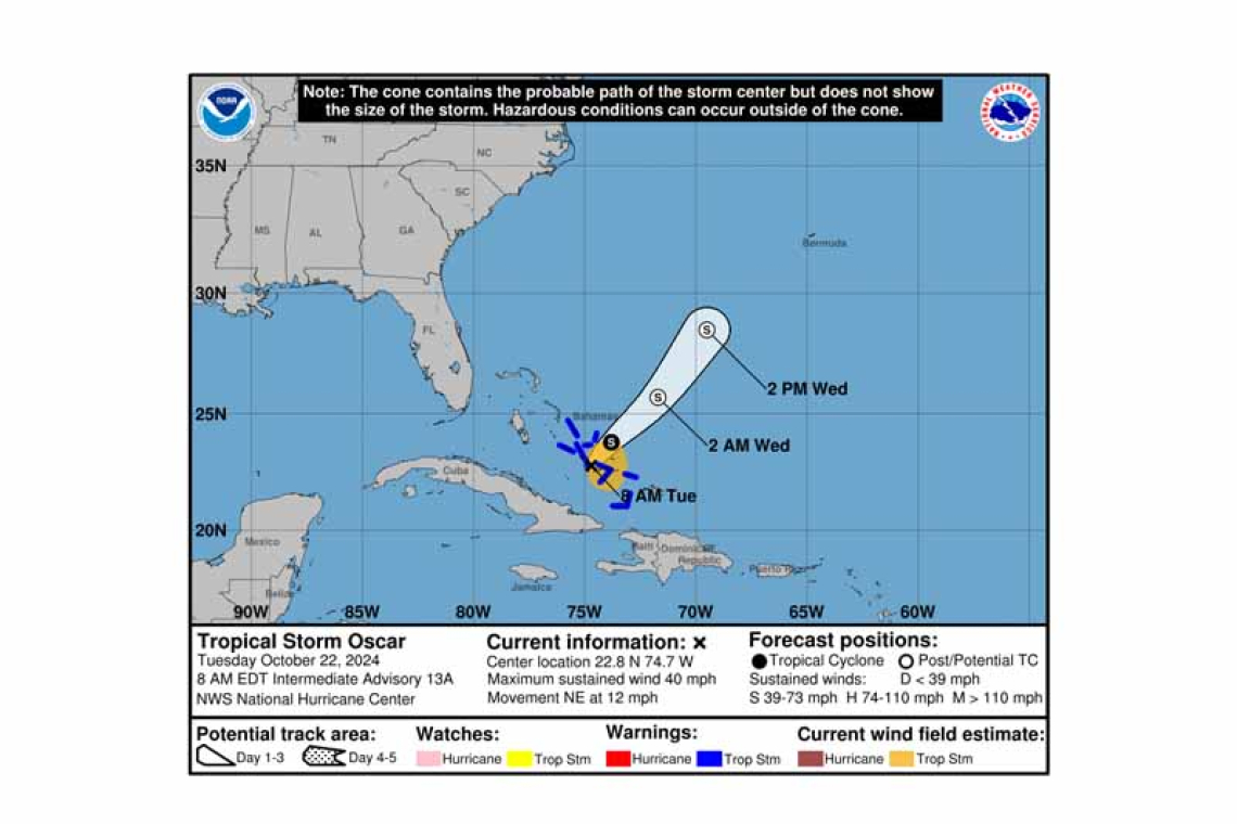
LOCATION...22.8N 74.7W
ABOUT 45 MI...75 KM SE OF LONG ISLAND
MAXIMUM SUSTAINED WINDS...40 MPH...65 KM/H
PRESENT MOVEMENT...NE OR 35 DEGREES AT 12 MPH...19 KM/H
MINIMUM CENTRAL PRESSURE...1006 MB...29.71 INCHES
WATCHES AND WARNINGS
--------------------
 CHANGES WITH THIS ADVISORY:
None.
SUMMARY OF WATCHES AND WARNINGS IN EFFECT:
A Tropical Storm Warning is in effect for...
* Central Bahamas
* Southeastern Bahamas
A Tropical Storm Warning means that tropical storm conditions are expected somewhere within the warning area.
For storm information specific to your area, please monitor products issued by your national meteor-ological service.
DISCUSSION AND OUTLOOK
----------------------
At 800 AM EDT (1200 UTC), the center of Tropical Storm Oscar was located near latitude 22.8 North, longitude 74.7 West. Oscar is moving toward the northeast near 12 mph (19 km/h). A faster north-eastward motion is expected later today and on Wednesday. On the forecast track, the center of Os-car is expected to move near the southeastern and central Bahamas today, then move away from the Bahamas tonight and Wednesday.
Maximum sustained winds are near 40 mph (65 km/h) with higher gusts. Little change in strength is forecast during the day today. Oscar is expected to become a post-tropical low by tonight or early Wednesday, and then be absorbed by another low pressure area by Thursday.
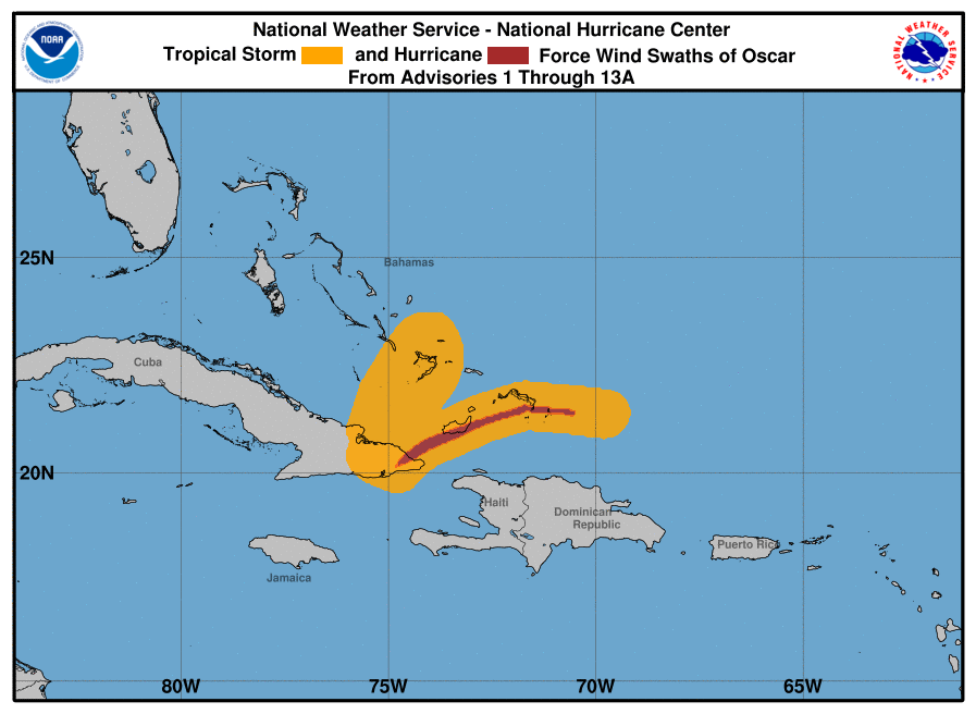
Tropical-storm-force winds extend outward up to 105 miles (165 km) east and northeast of the cen-ter.
The estimated minimum central pressure is 1006 mb (29.71 inches).
HAZARDS AFFECTING LAND
----------------------
 WIND: Tropical storm conditions are expected in the warning area in parts of the central and south-eastern Bahamas today.
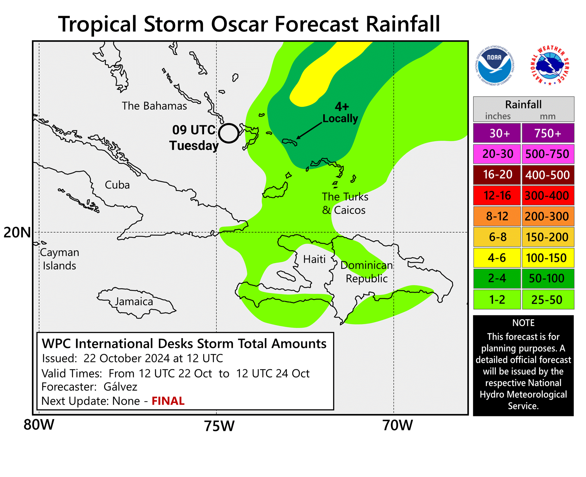
RAINFALL: Across the southeastern Bahamas and the Turks and Caicos Islands, rainfall amounts of 3 to 5 inches, with isolated amounts around 8 inches, are expected through today. This rainfall could cause localized flash flooding.
Forecaster Pasch


