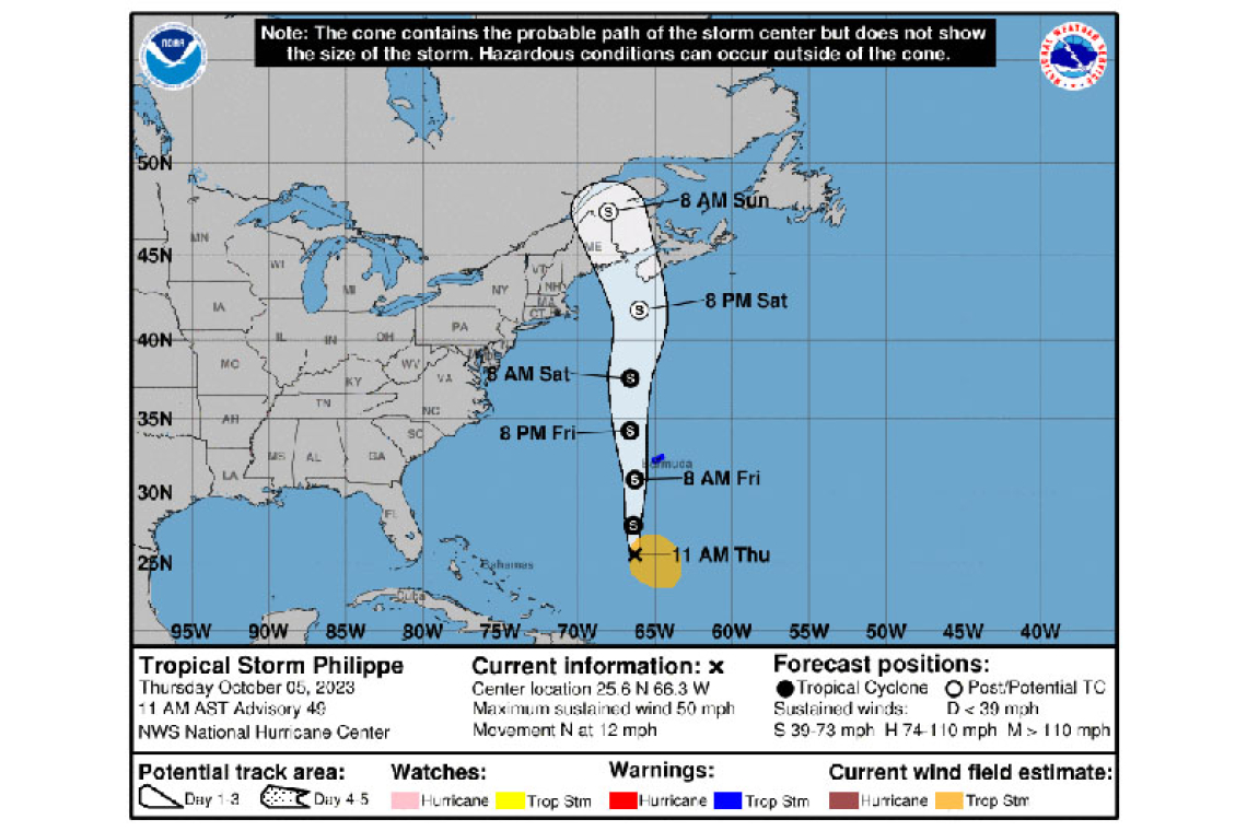
...TROPICAL STORM CONDITIONS EXPECTED TO BEGIN ON BERMUDA EARLY FRIDAY...
Tropical Storm Philippe Advisory Number 49
NWS National Hurricane Center Miami FL AL172023
1100 AM AST Thu Oct 05 2023
SUMMARY OF 1100 AM AST...1500 UTC...INFORMATION
-----------------------------------------------
LOCATION...25.6N 66.3W
ABOUT 470 MI...760 KM S OF BERMUDA
MAXIMUM SUSTAINED WINDS...50 MPH...85 KM/H
PRESENT MOVEMENT...N OR 355 DEGREES AT 12 MPH...19 KM/H
MINIMUM CENTRAL PRESSURE...1005 MB...29.68 INCHES
WATCHES AND WARNINGS
--------------------
CHANGES WITH THIS ADVISORY:
None.

SUMMARY OF WATCHES AND WARNINGS IN EFFECT:
A Tropical Storm Warning is in effect for...
* Bermuda
A Tropical Storm Warning means that tropical storm conditions are expected somewhere within the warning area within 36 hours.
Interests in eastern New England and Atlantic Canada should monitor the progress of Philippe.
For storm information specific to your area, please monitor products issued by your national meteorological service.
DISCUSSION AND OUTLOOK
----------------------
At 1100 AM AST (1500 UTC), the center of Tropical Storm Philippe was located near latitude 25.6 North, longitude 66.3 West. Philippe is moving toward the north near 12 mph (19 km/h), and this general motion with an increase in forward speed is expected to continue through late Saturday. A turn toward the north-northwest is possible Saturday night or early Sunday. On the forecast track, the center of Philippe will near or just west of Bermuda on Friday, and then reach the coast of Nova Scotia, New Brunswick, or eastern Maine Saturday night.
Data from an Air Force Reserve Hurricane Hunter aircraft indicate that maximum sustained winds have increased to near 50 mph (85 km/h) with higher gusts. Little change in strength is forecast during the next day or two. Some strengthening is possible Friday night or Saturday, but Philippe is expected to become a post-tropical cyclone on Saturday as it approaches Atlantic Canada and eastern New England.
Tropical-storm-force winds extend outward up to 230 miles (370 km) to the east of the center. Saildrone SD-1041, located about 135 miles (215 km) southeast of Philippe's center, recently measured a sustained wind of 38 mph (60 km/h) and a gust to 45 mph (73 km/h).
The estimated minimum central pressure is 1005 mb (29.68 inches).
HAZARDS AFFECTING LAND
----------------------
WIND: Tropical storm conditions are expected on Bermuda beginning early Friday morning.
RAINFALL: Rainfall will begin to affect Bermuda today with rainfall totals of 3 to 5 inches expected through Friday. These rainfall amounts could result in scattered flash flooding.
SURF: Large swells are already affecting Bermuda from another weather system but will begin to increase further later today as Philippe approaches the island. Swells are also reaching portions of the southeastern U.S. coast and will spread northward along the east coast to Atlantic Canada during the next couple of days. These conditions are likely to cause life-threatening surf and rip currents. Please consult products from your local weather office.
Forecaster Berg


