...EXPECTED TO BE NEAR MAJOR HURRICANE INTENSITY AT LANDFALL IN WESTERN CUBA...
BULLETIN
Hurricane Rafael Intermediate Advisory Number 11A
NWS National Hurricane Center Miami FL AL182024
700 AM EST Wed Nov 06 2024
SUMMARY OF 700 AM EST...1200 UTC...INFORMATION
----------------------------------------------
 LOCATION...21.0N 81.6W
ABOUT 90 MI...140 KM ESE OF THE ISLE OF YOUTH
ABOUT 160 MI...260 KM SSE OF HAVANA CUBA
MAXIMUM SUSTAINED WINDS...100 MPH...160 KM/H
PRESENT MOVEMENT...NW OR 315 DEGREES AT 14 MPH...22 KM/H
MINIMUM CENTRAL PRESSURE...964 MB...28.47 INCHES
WATCHES AND WARNINGS
--------------------
 CHANGES WITH THIS ADVISORY:
The government of the Cayman Islands has discontinued the Hurricane Warning for Grand Cayman.
The government of Cuba has discontinued the Tropical Storm Watch for the Cuban provinces of Ca-maguey and Las Tunas.
SUMMARY OF WATCHES AND WARNINGS IN EFFECT:
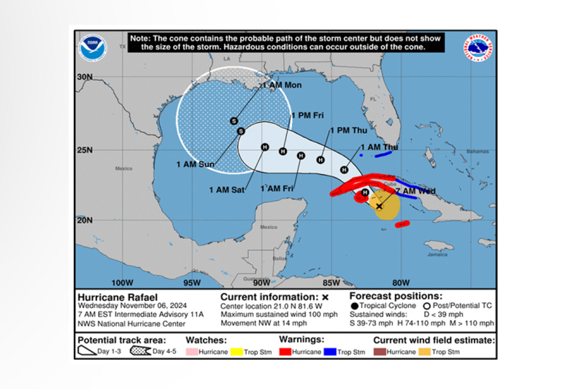
A Hurricane Warning is in effect for...
* Little Cayman and Cayman Brac
* Cuban provinces of Pinar del Rio, Artemisa, La Habana, Mayabeque, Matanzas and the Isle of Youth
A Tropical Storm Warning is in effect for...
* Cuban provinces of Villa Clara, Cienfuegos, Sancti Spiritus and Ciego de Avila
* Lower and Middle Florida Keys from Key West to west of the Channel 5 Bridge
* Dry Tortugas
A Hurricane Warning means that hurricane conditions are expected somewhere within the warning areas. Preparations to protect life and property should be rushed to completion.
A Tropical Storm Warning means that tropical storm conditions are expected somewhere within the
warning area.
For storm information specific to your area in the United States, including possible inland watches and warnings, please monitor products issued by your local National Weather Service forecast office. For storm information specific to your area outside of the United States, please monitor products issued by your national meteorological service.
DISCUSSION AND OUTLOOK
----------------------
At 700 AM EST (1200 UTC), the eye of Hurricane Rafael was located near latitude 21.0 North, longi-tude 81.6 West. Rafael is moving toward the northwest near 14 mph (22 km/h). A general north-westward motion is anticipated over the next day or two, followed by a gradual west-northwestward turn in the Gulf of Mexico. On the forecast track, Rafael is expected move near or over the Isle of Youth later this morning or early this afternoon, and make landfall in western Cuba later today. Rafael is forecast to move into the southeastern Gulf of Mexico tonight.
Reports from a NOAA Hurricane Hunter aircraft indicate that the maximum sustained winds have in-creased to near 100 mph (160 km/h) with higher gusts. Rapid strengthening is forecast, and Rafael could be near major hurricane intensity before it makes landfall in Cuba later today. Rafael is forecast to weaken over Cuba but is expected to emerge into the southeastern Gulf of Mexico as a hurricane.
Hurricane-force winds extend outward up to 15 miles (30 km) from the center and tropi-cal-storm-force winds extend outward up to 105 miles (165 km).
The minimum central pressure estimated from Air Force Hurricane Hunter aircraft observations is 964 mb (28.47 inches).
HAZARDS AFFECTING LAND
----------------------
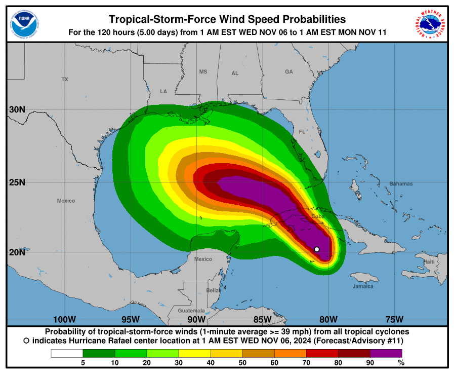
WIND: Hurricane conditions, possibly in gusts, are expected in portions of the Cayman Islands for the next couple of hours. Hurricane conditions are expected in western Cuba and the Isle of Youth today. Tropical storm conditions are expected in parts of west-central Cuba and the lower and middle Florida Keys today and
tonight. Tropical storm conditions are possible farther east in central Cuba today.
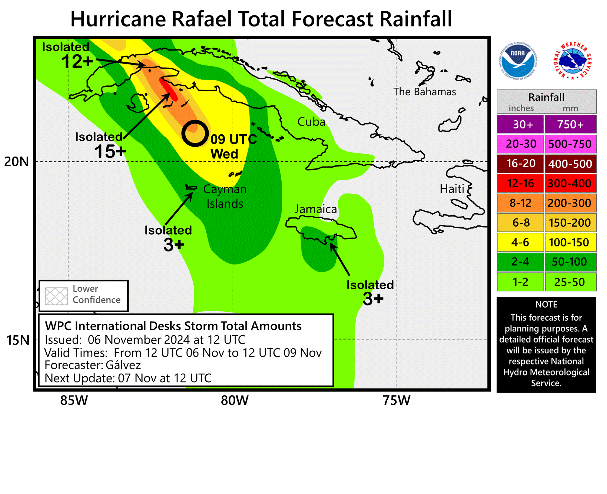
RAINFALL: Heavy rainfall will impact areas of the Western Caribbean through early Thursday, particu-larly across Jamaica and the Cayman Islands into western Cuba. Rainfall totals between 4 to 7 inches are expected across the Cayman Islands and western Cuba, with isolated higher totals up to 10 inches anticipated across areas of higher terrain. This will lead to areas of flash flooding and mudslides. Across Jamaica, heavy rain bands on the backside of Rafael will bring an additional 1 to 3 inches of rain.
Rainfall totals of 1 to 3 inches are expected for the Lower and Middle Florida Keys.
STORM SURGE: Storm surge could raise water levels by 1 to 3 feet above normal tide levels in the Cayman Islands, and could raise water levels by as much as 9 to 13 feet above normal tide levels in areas of onshore winds along the southern coast of Cuba in the Hurricane Warning area, including the Isle of Youth on Wednesday.
The combination of a storm surge and the tide will cause normally dry areas near the coast to be flooded by rising waters moving inland from the shoreline. The water could reach the following heights above ground somewhere in the indicated areas if the peak surge occurs at the time of high tide...
Dry Tortugas...1-3 ft
Lower Florida Keys...1-2 ft
TORNADOES: A few tornadoes are possible today over the Florida Keys and far southwestern Florida mainland.
SURF: Swells generated by Rafael are expected to affect much of the western Caribbean during the next few days and will also spread across most of the Gulf of Mexico from east to west late this week into the early part of the weekend. These swells are likely to cause life-threatening surf and rip cur-rent conditions. Please consult products from your local weather office.
Forecaster Brown


