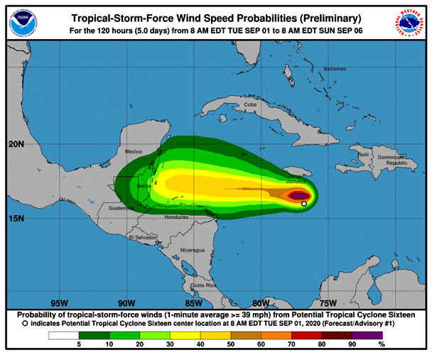
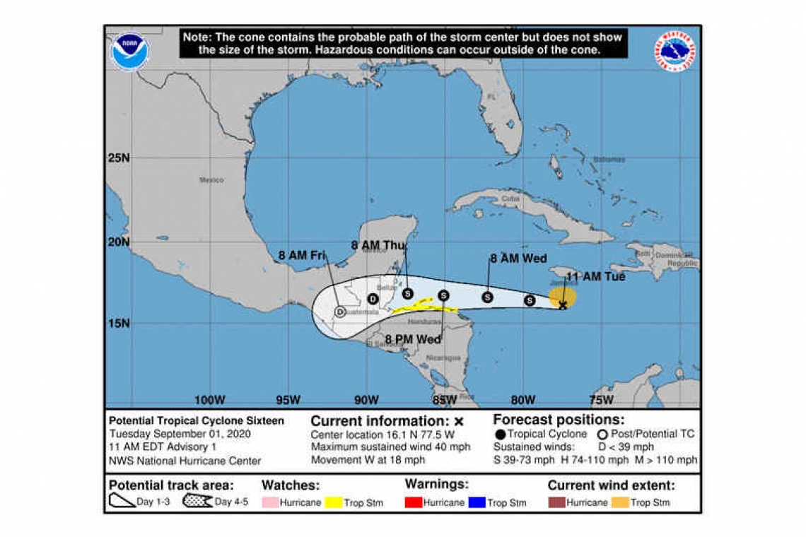
...TROPICAL STORM WATCH ISSUED FOR NORTHERN HONDURAS AND THE OFFSHORE ROATAN ISLANDS...
Potential Tropical Cyclone Sixteen Advisory Number 1
NWS National Hurricane Center Miami FL AL162020
1100 AM EDT Tue Sep 01 2020

SUMMARY OF 1100 AM EDT...1500 UTC...INFORMATION
-----------------------------------------------
LOCATION...16.1N 77.5W
ABOUT 140 MI...225 KM SSW OF KINGSTON JAMAICA
ABOUT 160 MI...260 KM SSE OF NEGRIL JAMAICA
MAXIMUM SUSTAINED WINDS...40 MPH...65 KM/H
PRESENT MOVEMENT...W OR 285 DEGREES AT 18 MPH...30 KM/H
MINIMUM CENTRAL PRESSURE...1005 MB...29.68 INCHES
WATCHES AND WARNINGS
--------------------
CHANGES WITH THIS ADVISORY:
A Tropical Storm Watch has been issued for the northern coast of Honduras from Punta Patuca westward to the Guatemala-Honduras border, including Roatan Island and the Bay Islands of Honduras.
SUMMARY OF WATCHES AND WARNINGS IN EFFECT:
A Tropical Storm Watch is in effect for...
* Northern Honduras
* Roatan Island and the Bay Islands of Honduras
A Tropical Storm Watch may be required for portions of Guatemala, Belize, and the southern Yucatan Peninsula later today.
A Tropical Storm Watch means that tropical storm conditions are possible within the watch area, generally within 48 hours.
DISCUSSION AND OUTLOOK
----------------------
At 1100 AM EDT (1500 UTC), the disturbance was centered near latitude 16.1 North, longitude 77.5 West. The system is moving toward the west near 18 mph (30 km/h), and this general motion is expected to continue through Thursday. On the forecast track, the system will be moving near but north of the coast of Honduras on Wednesday.
Maximum sustained winds are near 40 mph (65 km/h) with higher gusts. Some strengthening is forecast during the next 48 hours.
Additional development is expected today and on Wednesday, and a tropical depression or tropical storm could form at any time.
* Formation chance through 48 hours...high...90 percent
* Formation chance through 5 days...high...90 percent
Tropical-storm-force winds extend outward up to 80 miles (130 km), mainly northeast through northwest of the center.
The estimated minimum central pressure is 1005 mb (29.68 inches).
HAZARDS AFFECTING LAND
----------------------
WIND: Tropical storm conditions are possible within the watch area by late Wednesday.
RAINFALL: Rainfall amounts of 2 to 3 inches will be possible over the northern portions of Honduras beginning late Wednesday.
SURF: Swells generated by this system are affecting portions of the southern coast of Jamaica, and will continue into Wednesday morning. These swells are likely to cause life-threatening surf and rip current conditions. .
Forecaster Stewart


