...FORECAST TO BECOME A HURRICANE IN A COUPLE OF DAYS AS IT APPROACHES NICARAGUA AND HONDURAS...
Tropical Depression Twenty-Nine Advisory Number 1
NWS National Hurricane Center Miami FL AL292020
500 PM EDT Sat Oct 31 2020

SUMMARY OF 500 PM EDT...2100 UTC...INFORMATION
----------------------------------------------
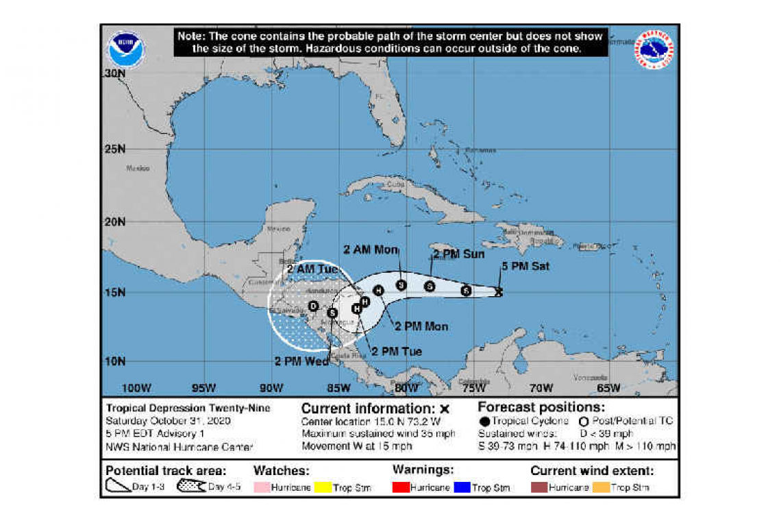
LOCATION...15.0N 73.2W
ABOUT 315 MI...510 KM SE OF KINGSTON JAMAICA
ABOUT 665 MI...1075 KM E OF CABO GRACIAS A DIOS ON NIC/HON BORDER
MAXIMUM SUSTAINED WINDS...35 MPH...55 KM/H
PRESENT MOVEMENT...W OR 270 DEGREES AT 15 MPH...24 KM/H
MINIMUM CENTRAL PRESSURE...1006 MB...29.71 INCHES
WATCHES AND WARNINGS
--------------------
There are no coastal watches or warnings in effect.
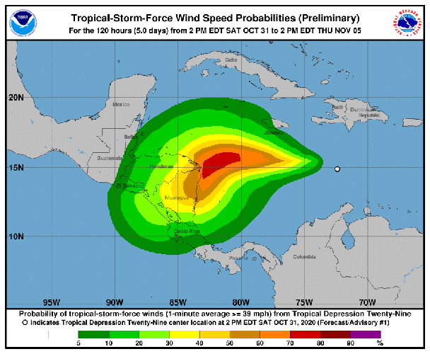
Interests in Nicaragua and Honduras should monitor the progress of the depression. Hurricane or tropical storm watches will likely be required for portions of these countries later tonight or early Sunday.
DISCUSSION AND OUTLOOK
----------------------
At 500 PM EDT (2100 UTC), the center of Tropical Depression Twenty-Nine was located near latitude 15.0 North, longitude 73.2 West. The depression is moving toward the west near 15 mph (24 km/h), and this westward motion is expected to continue through Sunday night. A slower motion toward the west-southwest and then southwest is forecast on Monday and Tuesday. On the forecast track, the center of the cyclone is expected to be near the northeastern coast of Nicaragua by Monday night.
Maximum sustained winds are near 35 mph (55 km/h) with higher gusts. Strengthening is forecast, and the depression is expected to become a tropical storm tonight. The system is then expected to become a hurricane by Monday.
The estimated minimum central pressure is 1006 mb (29.71 inches).
HAZARDS AFFECTING LAND
----------------------
RAINFALL: Through Thursday afternoon, the depression is expected to cause 5 to 10 inches of rain, with local 15-inch amounts, across Jamaica, the Cayman Islands, and possibly the southern coast of Hispaniola. Across portions of Central America, 10 to 15 inches of rain, with local amounts to 25 inches are expected. This rainfall should lead to flash flooding and river flooding, and could cause landslides in areas of higher terrain.
Forecaster Berg


