...DEPRESSION MOVING SLOWLY WESTWARD OVER THE BAY OF CAMPECHE...
...LIFE-THREATENING HEAVY RAINFALL AND FLOODING TO CONTINUE OVER PORTIONS OF MEXICO AND CENTRAL AMERICA...
BULLETIN
NWS National Hurricane Center Miami FL AL032020
700 AM CDT Tue Jun 02 2020
SUMMARY OF 700 AM CDT...1200 UTC...INFORMATION
----------------------------------------------
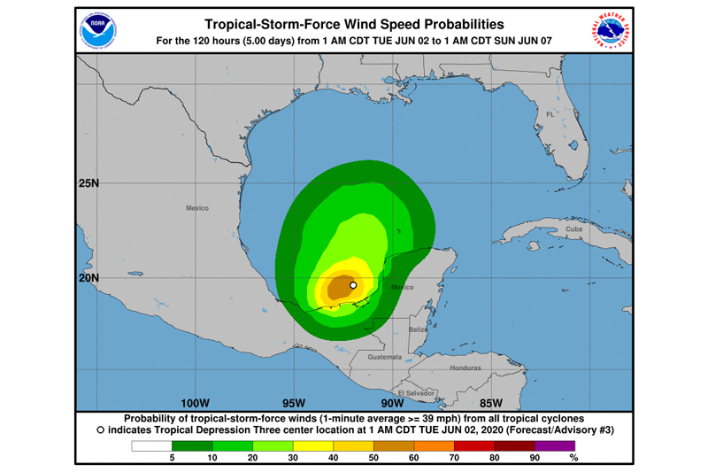
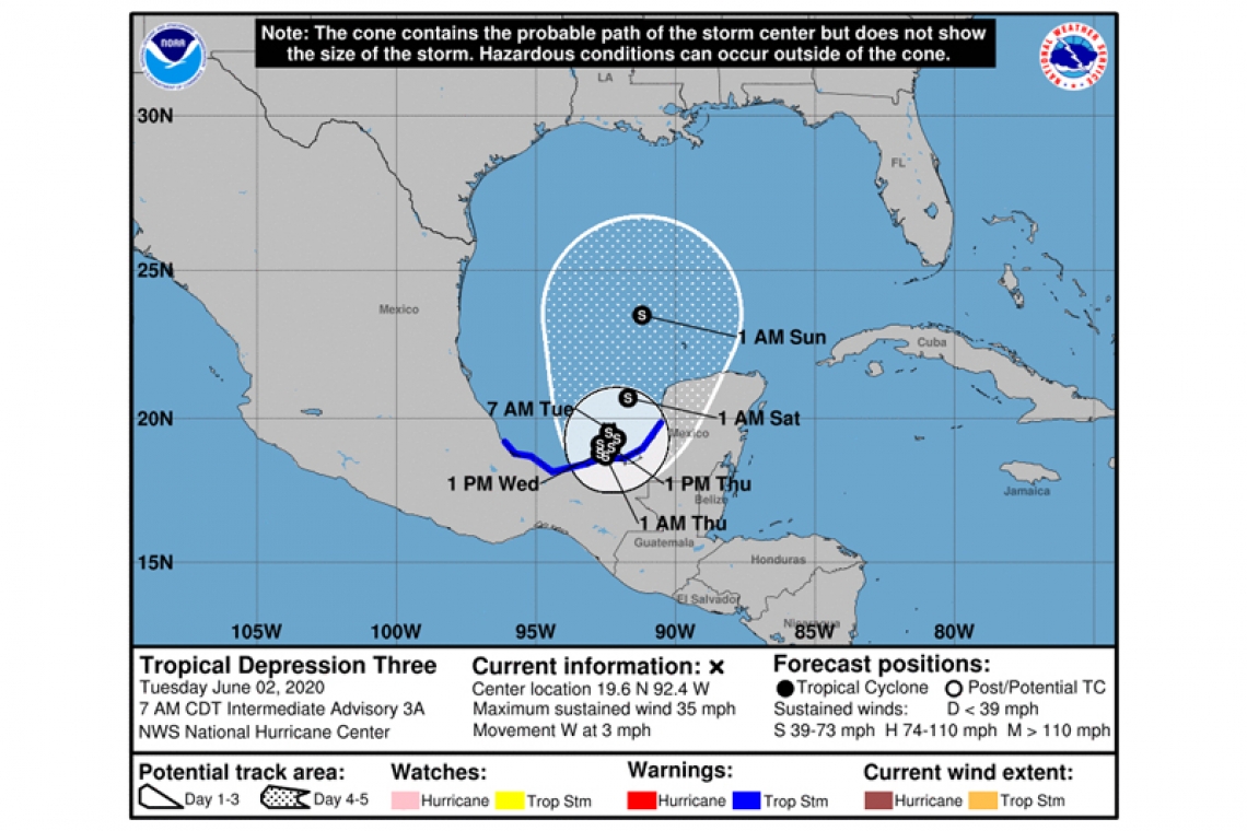
LOCATION...19.6N 92.4W
ABOUT 125 MI...200 KM W OF CAMPECHE MEXICO
ABOUT 160 MI...260 KM NE OF COATZACOALCOS MEXICO
MAXIMUM SUSTAINED WINDS...35 MPH...55 KM/H
PRESENT MOVEMENT...W OR 270 DEGREES AT 3 MPH...5 KM/H
MINIMUM CENTRAL PRESSURE...1003 MB...29.62 INCHES
WATCHES AND WARNINGS
--------------------
CHANGES WITH THIS ADVISORY:
None.
SUMMARY OF WATCHES AND WARNINGS IN EFFECT:
A Tropical Storm Warning is in effect for...
* Campeche to Puerto de Veracruz
A Tropical Storm Warning means that tropical storm conditions are expected somewhere within the warning area, in this case within the next within 24 to 36 hours.
DISCUSSION AND OUTLOOK
----------------------
At 700 AM CDT (1200 UTC), the center of Tropical Depression Three was located near latitude 19.6 North, longitude 92.4 West. The depression is moving toward the west near 3 mph (5 km/h). The depression is forecast to move slowly west-southwestward or southward this afternoon and tonight, and meander over the southern Bay of Campeche through late Wednesday. On the forecast track, the center of the cyclone is forecast to be near the coast of the southern Bay of Campeche tonight through Thursday.
Maximum sustained winds are near 35 mph (55 km/h) with higher gusts. Slow strengthening is expected during the next couple of days, and the depression is forecast to become a tropical storm later today. An Air Force Hurricane Hunter aircraft is scheduled to investigate the system later this morning.
The estimated minimum central pressure is 1003 mb (29.62 inches).
HAZARDS AFFECTING LAND
RAINFALL: Tropical Depression Three is expected to produce total rain accumulations of 10 to 20 inches with isolated maximum amounts of 25 inches over parts of the Mexican states of Tabasco, Veracruz, and Campeche. The depression is also expected to produce total rain accumulations of 10 to 15 inches over northern Chiapas and other Mexican states, Quintana Roo and Yucatan. Additional rainfall of 10 to 15 inches, with isolated amounts of 25 inches is expected along the Pacific coasts of Chiapas, Guatemala, and El Salvador. Some of these Pacific locations received 20 inches of rain over the weekend, and storm total amounts of 35 inches are possible. Rainfall in all of these areas may produce life-threatening flash floods and mudslides.
WIND: Tropical storm conditions are expected to first reach the coast within the warning area tonight.