
...HEAVY RAINS, COASTAL FLOODING, AND GUSTY WINDS FORECAST ALONG THE COASTS OF TEXAS AND NORTHEASTERN MEXICO THROUGH THURSDAY...
BULLETIN
Tropical Storm Alberto Advisory Number 8
NWS National Hurricane Center Miami FL AL012024
1000 AM CDT Wed Jun 19 2024
SUMMARY OF 1000 AM CDT...1500 UTC...INFORMATION
-----------------------------------------------
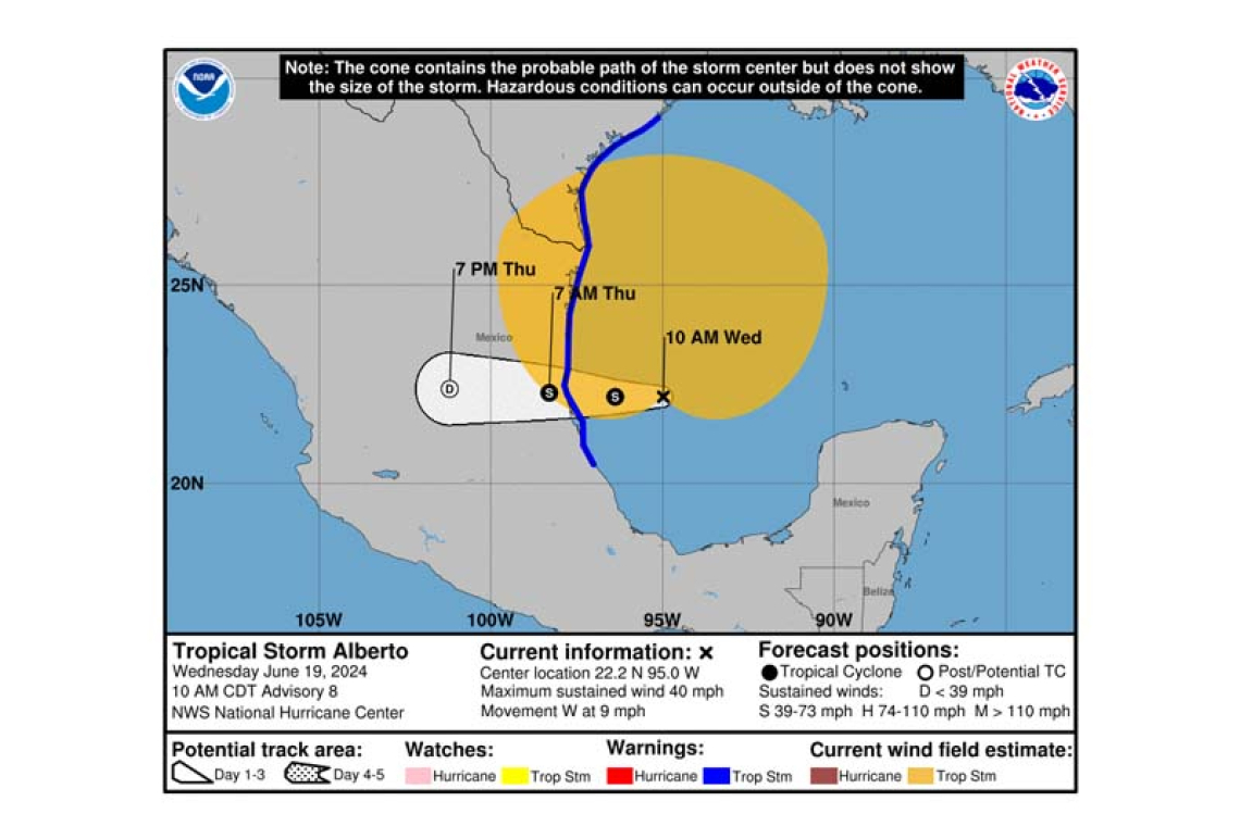
 LOCATION...22.2N 95.0W
ABOUT 185 MI...300 KM E OF TAMPICO MEXICO
ABOUT 295 MI...480 KM SSE OF BROWNSVILLE TEXAS
MAXIMUM SUSTAINED WINDS...40 MPH...65 KM/H
PRESENT MOVEMENT...W OR 270 DEGREES AT 9 MPH...15 KM/H
MINIMUM CENTRAL PRESSURE...995 MB...29.39 INCHES
WATCHES AND WARNINGS
--------------------
 CHANGES WITH THIS ADVISORY:
The government of Mexico has extended the Tropical Storm Warning southward to Tecolutla.
SUMMARY OF WATCHES AND WARNINGS IN EFFECT:
A Tropical Storm Warning is in effect for...
* the Texas coast from San Luis Pass southward to the mouth of the Rio Grande
* the northeastern coast of Mexico south of the mouth of the Rio Grande to Tecolutla.
A Tropical Storm Warning means that tropical storm conditions are expected somewhere within the warning area.
For storm information specific to your area in the United States, including possible inland watches and warnings, please monitor products issued by your local National Weather Service forecast office. For storm information specific to your area outside of the United States, please monitor products issued by your national
meteorological service.
DISCUSSION AND OUTLOOK
----------------------
 At 1000 AM CDT (1500 UTC), the center of Tropical Storm Alberto was located near latitude 22.2
North, longitude 95.0 West. Alberto is moving toward the west near 9 mph (15 km/h). A westward motion with an increase in forward speed is expected through Thursday. On the forecast track, the center of Alberto will reach the coast of northeastern Mexico early Thursday morning.
Maximum sustained winds are near 40 mph (65 km/h) with higher gusts. Some slight strengthening is forecast today or tonight before the center of Alberto reaches land. Rapid weakening is expected once the center moves inland, and Alberto is likely to dissipate over Mexico Thursday or Thursday night.
Alberto is a large tropical storm, with tropical-storm-force winds extending outward up to 415 miles (665 km) north of the center.
The minimum central pressure based on dropsonde data is 995 mb (29.39 inches).
HAZARDS AFFECTING LAND
----------------------
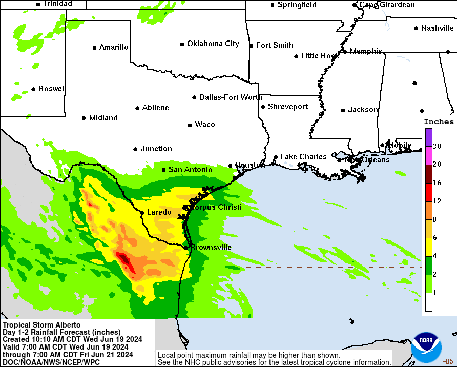
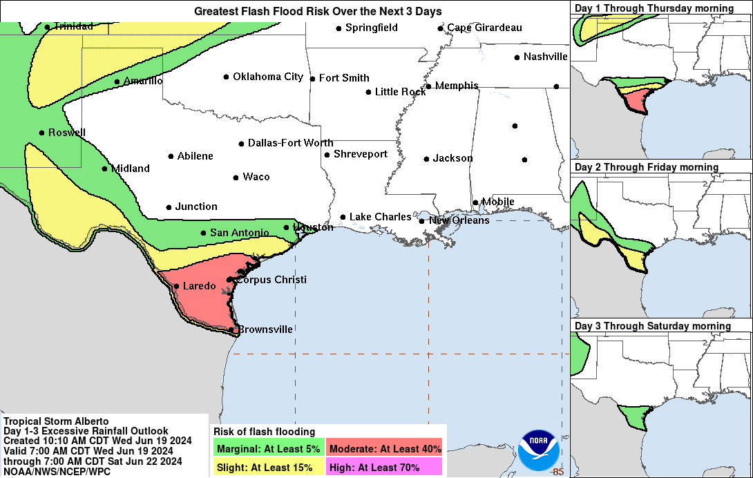
 RAINFALL: Tropical Storm Alberto is expected to produce rainfall totals of 5 to 10 inches across northeast Mexico into South Texas. Maximum totals around 20 inches are possible across the higher terrain of the Mexican states of Coahuila, Nuevo Leon and Tamaulipas. This rainfall will likely produce considerable flash and urban flooding along with new and renewed river flooding. Mudslides are also possible in areas of higher terrain across northeast Mexico.
STORM SURGE: The combination of a dangerous storm surge and the tide will cause normally dry ar-eas near the coast to be flooded by rising waters moving inland from the shoreline. The water could reach the following heights above ground somewhere in the indicated areas if the peak surge occurs at the time of high tide...
Sargent, TX to Sabine Pass, TX...2-4 ft
Galveston Bay...2-4 ft
Mouth of the Rio Grande, TX to Sargent, TX...1-3 ft
Sabine Pass, TX to Vermilion/Cameron Parish Line, LA...1-3 ft
The deepest water will occur along the immediate coast near and to the north of the landfall location, where the surge will be accompanied by large and dangerous waves. Surge-related flooding depends on the relative timing of the surge and the tidal cycle, and can vary greatly over short distances. For information specific to your area, please see products issued by your local National Weather Service forecast office.
Storm surge will raise water levels by as much as 1 to 3 feet above normal tide levels along the imme-diate coast of northeastern Mexico in areas of onshore winds north of where the center makes land-fall. Near the coast, the surge will be accompanied by large and destructive waves.
WIND: Tropical storm conditions are expected within the warning
area today through early Thursday.
TORNADOES: A couple of tornadoes are possible today and tonight across parts of Deep South Texas and Southeast Texas.
SURF: Swells generated by Alberto will affect the coast of Texas and northeastern Mexico through Friday. These swells are likely to cause life-threatening surf and rip current conditions. Please consult products from your local weather office.
Forecaster Berg


