..CRISTOBAL MOVING SLOWLY OVER THE BAY OF CAMPECHE...
...HEAVY RAIN AND LIFE-THREATENING FLOODING THREAT CONTINUES...
BULLETIN
NWS National Hurricane Center Miami FL AL032020
400 PM CDT Tue Jun 02 2020
SUMMARY OF 400 PM CDT...2100 UTC...INFORMATION
----------------------------------------------
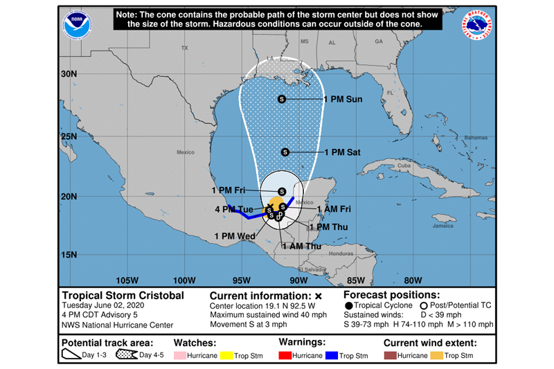
LOCATION...19.1N 92.5W
ABOUT 140 MI...230 KM WSW OF CAMPECHE MEXICO
MAXIMUM SUSTAINED WINDS...40 MPH...65 KM/H
PRESENT MOVEMENT...S OR 170 DEGREES AT 3 MPH...6 KM/H
MINIMUM CENTRAL PRESSURE...1004 MB...29.65 INCHES
WATCHES AND WARNINGS
--------------------
CHANGES WITH THIS ADVISORY:
None.
SUMMARY OF WATCHES AND WARNINGS IN EFFECT:
A Tropical Storm Warning is in effect for...
* Campeche to Puerto de Veracruz
DISCUSSION AND OUTLOOK
----------------------
At 400 PM CDT (2100 UTC), the center of Tropical Storm Cristobal was located near latitude 19.1 North, longitude 92.5 West. Cristobal is moving toward the south near 3 mph (6 km/h), and a turn toward the southeast and east is expected tonight and Wednesday, followed by a turn toward the north-northeast and north on Thursday night and Friday. On the forecast track, the center will cross the southern Bay of Campeche coast on Wednesday and move inland over eastern Mexico Wednesday night and Thursday, and move back over the Bay of Campeche Thursday night and Friday.
Maximum sustained winds are near 40 mph (65 km/h) with higher gusts. Some increase in strength is possible until the center crosses the coast. Gradual weakening is forecast while the center remains inland, but restrengthening is expected after Cristobal moves back over water Thursday night and Friday.
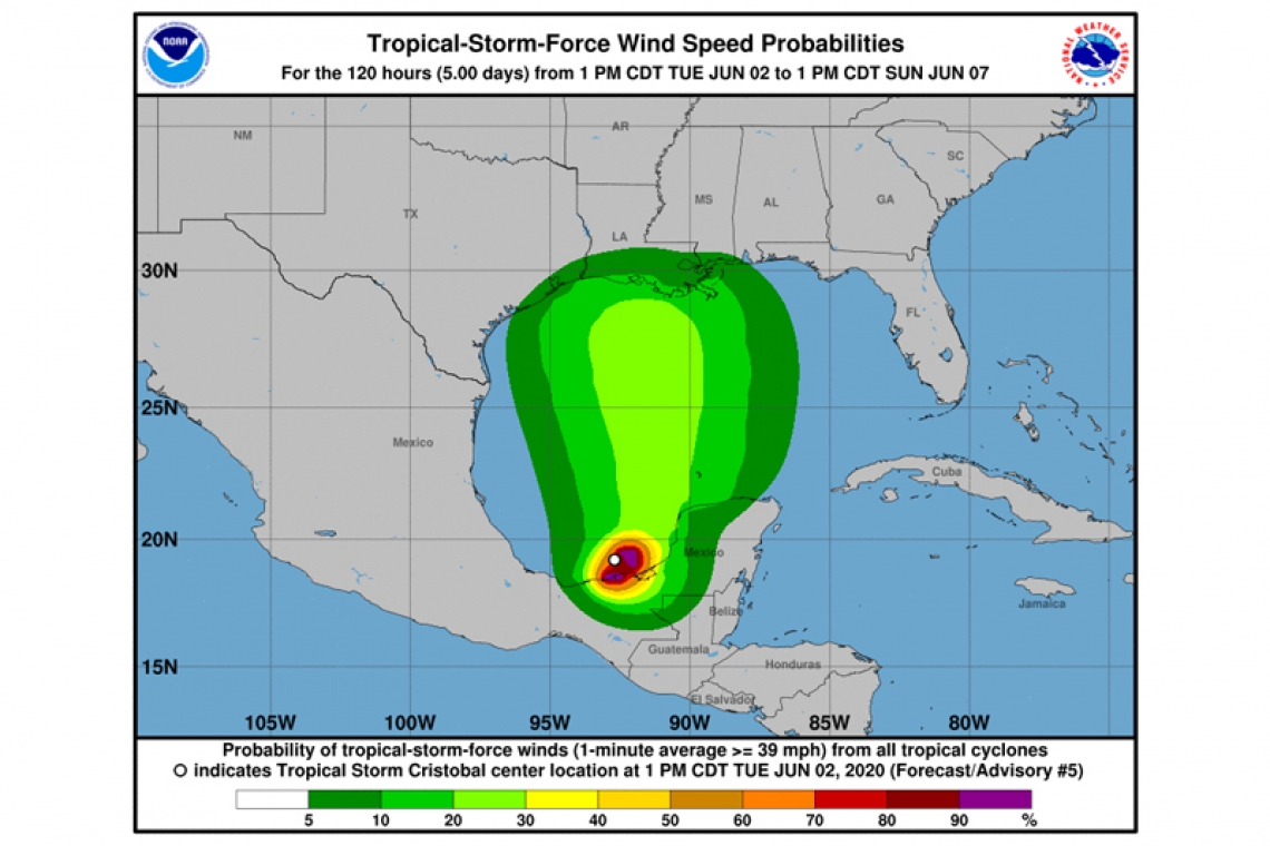
Tropical-storm-force winds extend outward up to 85 miles (140 km) from the center.
The estimated minimum central pressure is 1004 mb (29.65 inches).
HAZARDS AFFECTING LAND
RAINFALL: Cristobal is expected to produce total rain accumulations of 10 to 20 inches with isolated maximum amounts of 25 inches over parts of the Mexican states of Tabasco, Veracruz, and Campeche. Cristobal is also expected to produce total rain accumulations of 10 to 15 inches over northern Chiapas, Quintana Roo and Yucatan. Additional rainfall of 10 to 15 inches, with isolated amounts of 25 inches is expected along the Pacific coasts of Chiapas, Guatemala, and El Salvador. Some of these Pacific locations received 20 inches of rain over the weekend, and storm total amounts of 35 inches are possible. Rainfall in all of these areas may produce life-threatening flash floods and mudslides.
WIND: Tropical storm conditions are affecting the coast within portions of the warning area.