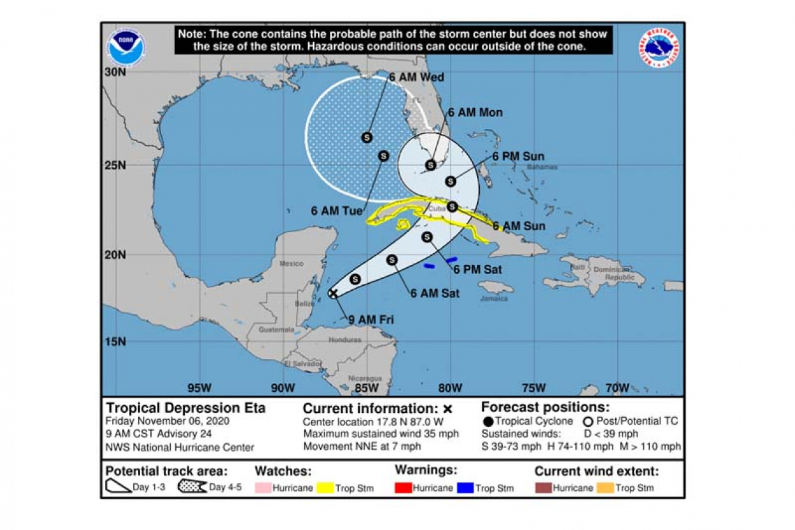
...ETA STILL CAUSING HEAVY RAINS AND LIFE-THREATENING FLOODING OVER PORTIONS OF CENTRAL AMERICA...
Tropical Depression Eta Advisory Number 24
NWS National Hurricane Center Miami FL AL292020
900 AM CST Fri Nov 06 2020
SUMMARY OF 900 AM CST...1500 UTC...INFORMATION
----------------------------------------------
LOCATION...17.8N 87.0W
ABOUT 80 MI...130 KM ENE OF BELIZE CITY
ABOUT 395 MI...635 KM WSW OF GRAND CAYMAN
MAXIMUM SUSTAINED WINDS...35 MPH...55 KM/H
PRESENT MOVEMENT...NNE OR 25 DEGREES AT 7 MPH...11 KM/H
MINIMUM CENTRAL PRESSURE...1004 MB...29.65 INCHES
WATCHES AND WARNINGS
--------------------
CHANGES WITH THIS ADVISORY:
The Meteorological Service of the Cayman Islands has issued a Tropical Storm Warning for the Cayman Islands.
The Government of Cuba has issued a Tropical Storm Watch for the provinces of Camaguey, Ciego de Avila, Sancti Spiritus, Villa Clara, Cienfuegos, Matanzas, La Habana, Ciudad de la Habana, Pinar del Rio and the Isle of Youth.
SUMMARY OF WATCHES AND WARNINGS IN EFFECT:
A Tropical Storm Warning is in effect for...
* The Cayman Islands
A Tropical Storm Watch is in effect for...
* The Cuban provinces of Camaguey, Ciego de Avila, Sancti Spiritus, Villa Clara, Cienfuegos, Matanzas, La Habana, Ciudad de la Habana, Pinar del Rio and the Isle of Youth.
A Tropical Storm Warning means that tropical storm conditions are expected somewhere within the warning area within 36 hours.
A Tropical Storm Watch means that tropical storm conditions are possible within the watch area, generally within 48 hours.
The governments of Nicaragua and Honduras continue to issue warnings for heavy rain and flooding in those countries, and interests in those areas should continue to monitor the depression.
Interests elsewhere in Cuba, the northwestern Bahamas, the Florida Keys and southern Florida should monitor the progress of this system as Tropical Storm or Hurricane Watches could be required for some of these areas later today.
For storm information specific to your area, please monitor products issued by your national meteorological service.
DISCUSSION AND OUTLOOK
----------------------
At 900 AM CST (1500 UTC), the center of Tropical Depression Eta was located near latitude 17.8 North, longitude 87.0 West. The depression is moving toward the north-northeast near 7 mph (11 km/h). A turn toward the northeast and a faster forward speed are expected later today, with this motion continuing through early Sunday. On the forecast track, the center of Eta will move across the northwestern Caribbean Sea today, approach the Cayman Islands Saturday, and be near central or western Cuba Saturday night and Sunday.
Maximum sustained winds are near 35 mph (55 km/h) with higher gusts. Eta is forecast to become a tropical storm again later today, with further strengthening likely through early Sunday.
The estimated minimum central pressure is 1004 mb (29.65 inches).
HAZARDS AFFECTING LAND
----------------------
RAINFALL: Eta is expected to produce the following rainfall amounts through Wednesday morning:
Portions of Central America: An additional 5 to 10 inches (125 to 255 mm), isolated maximum storm totals of 40 inches (1000 mm) in eastern Honduras and eastern Nicaragua.
Southeastern Mexico and Jamaica: An additional 2 to 5 inches (50 to 125 mm), isolated maximum storm totals of 15 inches (380 mm).
The Cayman Islands into portions of Cuba: 10 to 20 inches (255 to 510 mm), isolated maximum totals of 30 inches (760 mm).
The Bahamas and Southern Florida, including the Keys: 5 to 10 inches (125 to 255 mm), isolated maximum totals of 15 inches (380 mm).
This rainfall will continue catastrophic, life-threatening flash flooding and river flooding, along with landslides in areas of higher terrain of Central America. Significant, life-threatening flash flooding and river flooding is possible in the Cayman Islands and Cuba. Flash flooding and river flooding is expected for Jamaica and southeast Mexico. Flash and urban flooding is possible across the Bahamas and Southern Florida.
WIND: Tropical storm conditions are expected in the Cayman Islands late Saturday and Saturday night. Tropical storm conditions are possible in the watch area in Cuba Saturday night and Sunday.
SURF: Swells generated by Eta are expected to spread northeastward and affect the Cayman Islands, Jamaica, and the southern coast of Cuba during the next couple of days. These swells are likely to cause life-threatening surf and rip current conditions. Please consult products from your local weather office.
Forecaster Beven


