
NWS National Hurricane Center Miami FL
800 AM EDT Fri Sep 6 2024
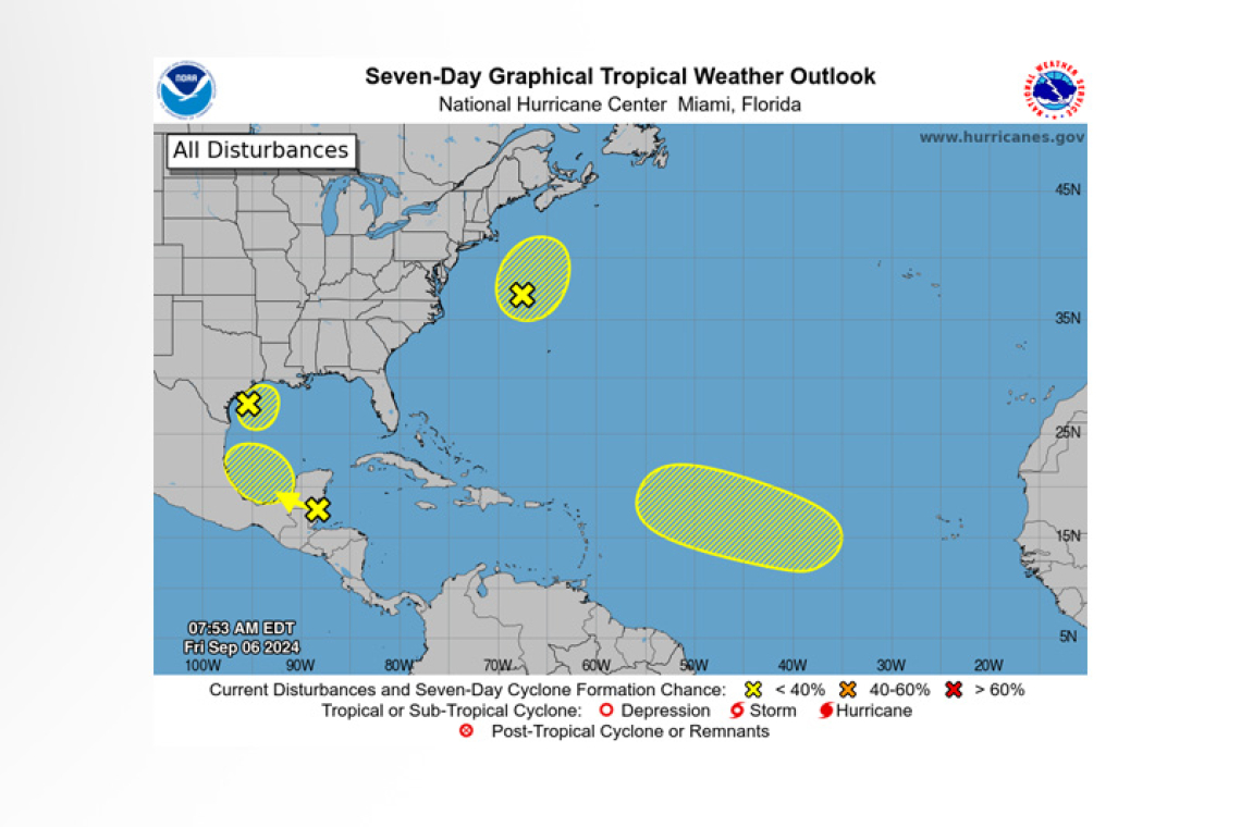
For the North Atlantic...Caribbean Sea and the Gulf of Mexico:
Northwestern Gulf of Mexico (AL90):
Showers and thunderstorms associated with a low pressure system and weak frontal boundary over the northwestern Gulf of Mexico remain disorganized. Upper-level winds are expected to remain unfavorable for significant development of this system while it meanders over the northwestern Gulf and eventually merges with another approaching frontal system later today or on Saturday. Although tropical cyclone development is unlikely, heavy rainfall is expected to continue across portions of the northern Gulf Coast during the next day or so. Additional information on this system can be found in products issued by your local National Weather Service Forecast Office and High Seas Forecasts issued by the National Weather Service.
* Formation chance through 48 hours...low...10 percent.
* Formation chance through 7 days...low...10 percent.
Northwestern Atlantic (AL99):
 Satellite images indicate that a gale-force low pressure system located several hundred miles east of the U.S. Mid-Atlantic coast is producing a large area of showers and thunderstorms that are increasingly taking on a non-tropical structure. The low is forecast to move north-northeastward at 15 to 20 mph offshore the northeastern United States, reaching colder waters by this evening
and overnight, and its opportunity to acquire subtropical characteristics appears to be decreasing. Additional information on this system, including gale warnings, can be found in High Seas Forecasts issued by the National Weather Service.
* Formation chance through 48 hours...low...20 percent.
* Formation chance through 7 days...low...20 percent.
Northwestern Caribbean Sea and Southwestern Gulf of Mexico:
A tropical wave located near the coast of Belize and the Yucatan Peninsula of Mexico continues to produce disorganized showers and thunderstorms. The wave is forecast to move across Central America and southeastern Mexico today and tonight, and some slow development is possible over the weekend after the system emerges over the southwestern Gulf of Mexico.
* Formation chance through 48 hours...low...near 0 percent.
* Formation chance through 7 days...low...20 percent.
Eastern and Central Tropical Atlantic:
An elongated trough of low pressure over the eastern tropical Atlantic is producing minimal shower and thunderstorm activity. Development, if any, should be slow to occur while the disturbance meanders through the early part of next week and then begins to move west-northwestward across the central tropical Atlantic during the middle to latter part of next week.
* Formation chance through 48 hours...low...near 0 percent.
* Formation chance through 7 days...low...10 percent.
Forecaster Berg


