
...NEW WATCHES AND WARNINGS ISSUED FOR PORTIONS OF MEXICO...
Hurricane Milton Special Advisory Number 9
NWS National Hurricane Center Miami FL AL142024
700 AM CDT Mon Oct 07 2024
SUMMARY OF 700 AM CDT...1200 UTC...INFORMATION
----------------------------------------------
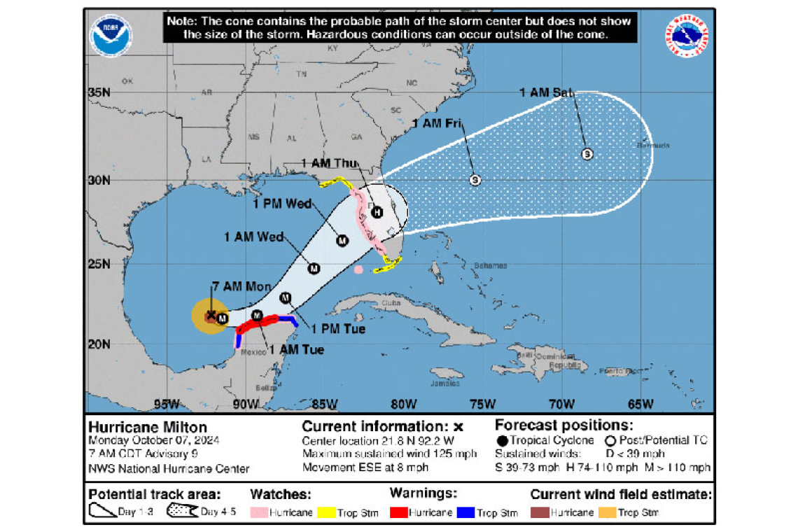
LOCATION...21.8N 92.2W
ABOUT 165 MI...265 KM WNW OF PROGRESO MEXICO
ABOUT 745 MI...1195 KM WSW OF TAMPA FLORIDA
MAXIMUM SUSTAINED WINDS...125 MPH...205 KM/H
PRESENT MOVEMENT...ESE OR 115 DEGREES AT 8 MPH...13 KM/H
MINIMUM CENTRAL PRESSURE...945 MB...27.91 INCHES
WATCHES AND WARNINGS
--------------------
CHANGES WITH THIS ADVISORY:
The government of Mexico has issued a Hurricane Watch and a Tropical Storm Warning from south of Celestun to Campeche.
SUMMARY OF WATCHES AND WARNINGS IN EFFECT:
A Hurricane Warning is in effect for...
* Celestun to Rio Lagartos
A Hurricane Watch is in effect for...
* Rio Lagartos to Cabo Catoche
* Campeche to south of Celestun
* Florida Gulf coast from Chokoloskee to the mouth of the Suwanee River, including Tampa Bay
* Dry Tortugas
A Storm Surge Watch is in effect for...
* Florida Gulf coast from Flamingo northward to the mouth of the Suwannee River, including Charlotte Harbor and Tampa Bay
A Tropical Storm Warning is in effect for...
* Rio Lagartos to Cancun
* Campeche to south of Celestun
A Tropical Storm Watch is in effect for...
* Florida Gulf coast from Flamingo to south of Chokoloskee
* Florida Gulf coast north of the mouth of the Suwanee River to Indian Pass
* Lower, Middle, and Upper Florida Keys, including Florida Bay
A Hurricane Warning means that hurricane conditions are expected somewhere within the warning area. A warning is typically issued 36 hours before the anticipated first occurrence of tropical-storm-force winds, conditions that make outside preparations difficult or dangerous. Preparations to protect life and property should be rushed to completion.
A Tropical Storm Warning means that tropical storm conditions are expected somewhere within the warning area within 36 hours.
A Storm Surge Watch means there is a possibility of life-threatening inundation, from rising water moving inland from the coastline, in the indicated locations during the next 48 hours.
A Hurricane Watch means that hurricane conditions are possible within the watch area. A watch is typically issued 48 hours before the anticipated first occurrence of tropical-storm-force winds, conditions that make outside preparations difficult or dangerous.
A Tropical Storm Watch means that tropical storm conditions are possible within the watch area, generally within 48 hours.
Interests in the remainder of the Yucatan peninsula of Mexico, the Florida Peninsula, the Florida Keys, and the northwestern Bahamas should monitor the progress of this system. Additional watches and warnings will likely be issued later today.
For storm information specific to your area in the United States, including possible inland watches and warnings, please monitor products issued by your local National Weather Service forecast office. For storm information specific to your area outside of the United States, please monitor products issued by your national meteorological service.
DISCUSSION AND OUTLOOK
----------------------
At 700 AM CDT (1200 UTC), the eye of Hurricane Milton was located near latitude 21.8 North, longitude 92.2 West. Milton is moving toward the east-southeast near 8 mph (13 km/h). An eastward to east-southeastward motion is forecast through tonight, followed by a turn toward the east and northeast on Tuesday and Wednesday. On the forecast track, Milton is forecast to move near or just north of
the Yucatan Peninsula today and Tuesday, then cross the eastern Gulf of Mexico and approach the west coast of the Florida Peninsula by Wednesday.
Maximum sustained winds have increased to near 125 mph (205 km/h) with higher gusts. Milton is a category 3 hurricane on the Saffir-Simpson Hurricane Wind Scale. Further strengthening is expected, and Milton is forecast to become an extremely dangerous category 4 hurricane later today and maintain that intensity for the next couple of days.
Hurricane-force winds extend outward up to 35 miles (55 km) from the center and tropical-storm-force winds extend outward up to 80 miles (130 km).
The estimated minimum central pressure is 945 mb (27.91 inches) based Air Force dropsonde data.
HAZARDS AFFECTING LAND
----------------------
STORM SURGE: A storm surge will raise water levels by as much as 3 to 5 feet above ground level along the northern coast of the Yucatan Peninsula in areas of onshore winds. Near the coast, the surge will be accompanied by large and destructive waves.
The combination of a dangerous storm surge and the tide will cause normally dry areas near the coast to be flooded by rising waters moving inland from the shoreline. The water could reach the following heights above ground somewhere in the indicated areas if the peak surge occurs at the time of high tide...
Anclote River, FL to Englewood, FL...8-12 ft
Tampa Bay...8-12 ft
Yankeetown, FL to Anclote River, FL...5-10 ft
Englewood, FL to Bonita Beach, FL...5-10 ft
Charlotte Harbor...5-10 ft
Bonita Beach, FL to Chokoloskee, FL...4-7 ft
Suwannee River, FL to Yankeetown, FL...3-5 ft
The deepest water will occur along the immediate coast near and to the south of the landfall location, where the surge will be accompanied by large and dangerous waves. Surge-related flooding depends on the relative timing of the surge and the tidal cycle, and can vary greatly over short distances. For information specific to your area, please see products issued by your local National Weather Service forecast office.
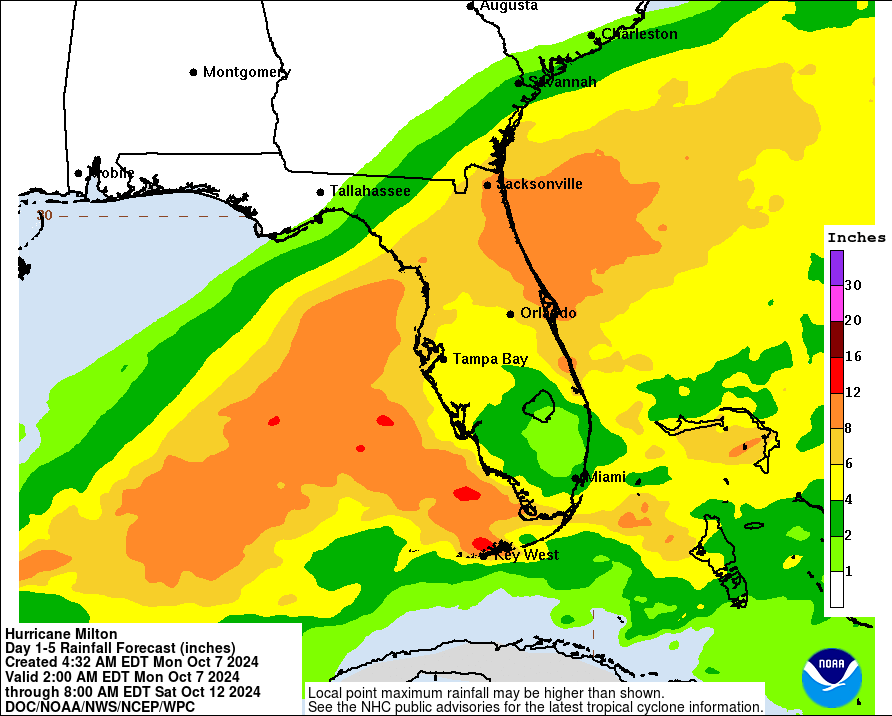
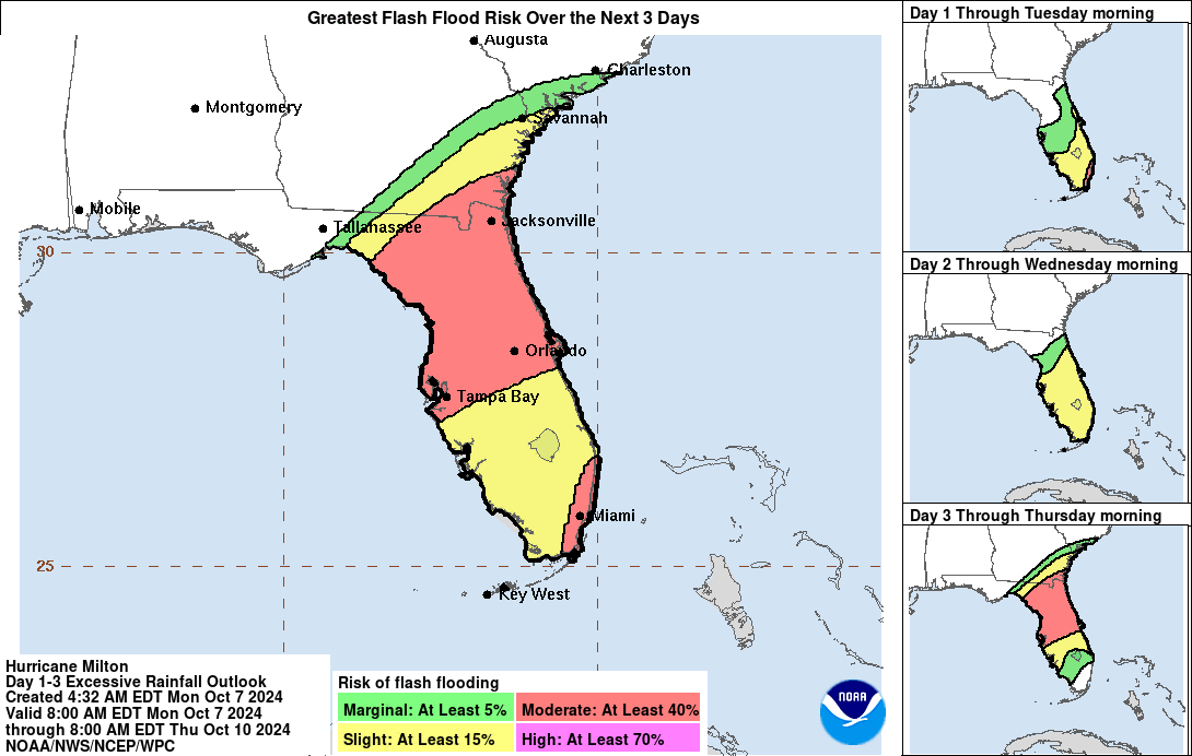
RAINFALL: Rainfall amounts of 5 to 10 inches, with localized totals up to 15 inches, are expected across portions of the Florida Peninsula and the Keys through Wednesday night. This rainfall brings the risk of considerable flash, urban, and areal flooding, along with the potential for moderate to major river flooding.
Milton will also produce rainfall totals of 2 to 4 inches across portions of the northern Yucatan Peninsula.
WIND: Hurricane conditions are expected in the warning area in Mexico beginning late today or tonight, with tropical storm conditions expected to begin as early as this morning. Hurricane conditions are possible in the watch area in Mexico beginning tonight and Tuesday, and tropical storm conditions are expected in the tropical storm warning area beginning later today. Hurricane conditions are possible in the Hurricane Watch area in Florida on Wednesday, and tropical storm conditions are possible in the Tropical Storm Watch area on Wednesday.
SURF: Swells generated by the system are affecting the coast of the southwestern Gulf of Mexico. These swells are expected to spread northward and eastward along much of the Gulf Coast within the next day or two, and are likely to cause life-threatening surf and rip current conditions. Please consult products from your local weather office.
Forecaster Blake


