
...LIFE-THREATENING STORM SURGE AND HURRICANE-FORCE WINDS EXPECTED TO BEGIN IN LOUISI-ANA THIS AFTERNOON...
Hurricane Francine Advisory Number 12
NWS National Hurricane Center Miami FL AL062024
1000 AM CDT Wed Sep 11 2024
SUMMARY OF 1000 AM CDT...1500 UTC...INFORMATION
-----------------------------------------------
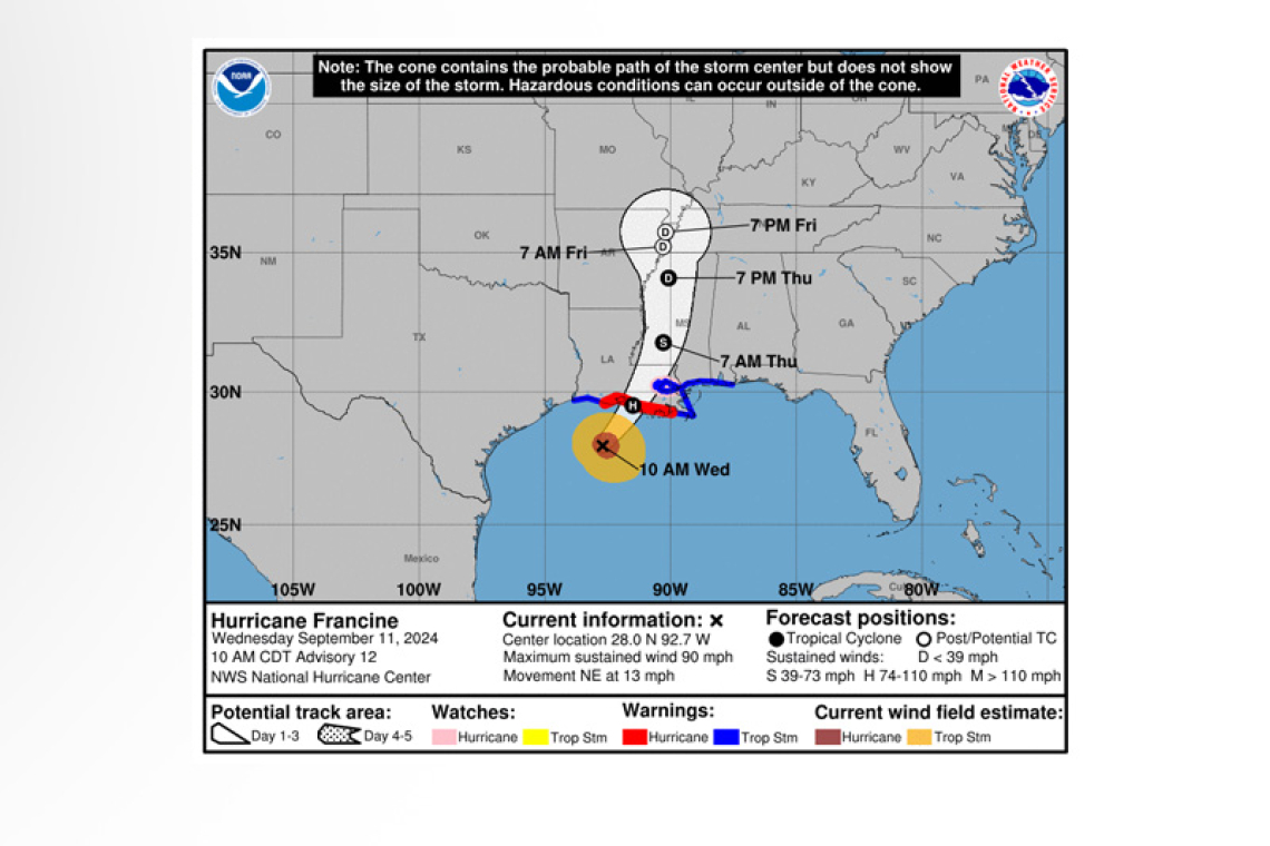
 LOCATION...28.0N 92.7W
ABOUT 150 MI...240 KM SW OF MORGAN CITY LOUISIANA
ABOUT 210 MI...335 KM SW OF NEW ORLEANS LOUISIANA
MAXIMUM SUSTAINED WINDS...90 MPH...150 KM/H
PRESENT MOVEMENT...NE OR 40 DEGREES AT 13 MPH...20 KM/H
MINIMUM CENTRAL PRESSURE...976 MB...28.82 INCHES
WATCHES AND WARNINGS
--------------------
 CHANGES WITH THIS ADVISORY:
The Storm Surge Watch for the Alabama coast, including Mobile Bay, has been changed to a Coastal Flood Warning. Please refer to products from local National Weather Service Offices for additional information.
SUMMARY OF WATCHES AND WARNINGS IN EFFECT:
A Storm Surge Warning is in effect for...
* Cameron Louisiana to the Mississippi/Alabama Border
* Vermilion Bay
* Lake Maurepas
* Lake Pontchartrain
 A Hurricane Warning is in effect for...
* The Louisiana coast from Vermilion/Cameron Line eastward to Grand Isle
A Hurricane Watch is in effect for...
* Lake Maurepas and Lake Pontchartrain, including metropolitan New Orleans
A Tropical Storm Warning is in effect for...
* Louisiana coast east of Sabine Pass to Vermilion/Cameron Line
* East of Grand Isle Louisiana to the Alabama/Florida border
* Lake Maurepas and Lake Pontchartrain, including metropolitan New Orleans
 A Storm Surge Warning means there is a danger of life-threatening inundation, from rising water moving inland from the coastline, beginning this afternoon for the indicated locations. This is a life-threatening situation. Persons located within these areas should take all necessary actions to protect life and property from rising water and the potential for other dangerous conditions. Prompt-ly follow evacuation and other instructions from local officials.
A Hurricane Warning means that hurricane conditions are expected somewhere within the warning area, in this case within 24 hours. Preparations to protect life and property should be rushed to com-pletion.
A Hurricane Watch means that hurricane conditions are possible within the watch area, in this case within 24 hours.
A Tropical Storm Warning means that tropical storm conditions are expected somewhere within the warning area, in this case within 24 hours.
For storm information specific to your area, including possible inland watches and warnings, please monitor products issued by your local National Weather Service forecast office.
DISCUSSION AND OUTLOOK
----------------------
At 1000 AM CDT (1500 UTC), the center of Hurricane Francine was located near latitude 28.0 North, longitude 92.7 West. Francine is moving toward the northeast near 13 mph (20 km/h). A faster northeastward motion is expected this afternoon, and Francine is anticipated to make landfall in Loui-siana within the warning area late this afternoon or this evening. After landfall, the center is expected to cross southeastern Louisiana tonight, then move northward across Mississippi on Thursday and Thursday night.
Reports from Air Force Reserve and NOAA Hurricane hunter aircraft indicate that maximum sustained winds are near 90 mph (150 km/h) with higher gusts. Little change in strength is expected before landfall. Francine is expected to rapidly weaken after landfall, and the system is forecast to become post-tropical on Thursday.
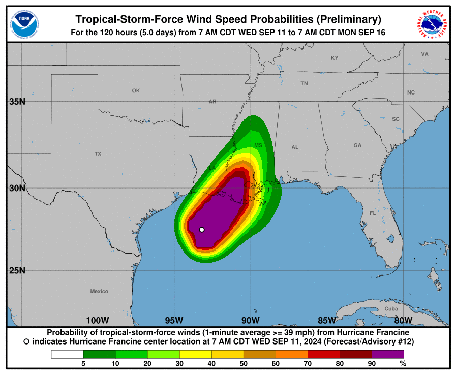
Hurricane-force winds extend outward up to 40 miles (65 km) from the center and tropi-cal-storm-force winds extend outward up to 115 miles (185 km). An oil platform north of the center recently reported sustained winds of 87 mph (141 km/h) and a peak gust of 105 mph (169 km/h) at an elevation of 98 ft (30 m).
The minimum central pressure based on the Hurricane Hunter aircraft data is 976 mb (28.82 inches). An oil platform located east of the center recently reported a pressure of 978.7 mb (28.90 inches).
HAZARDS AFFECTING LAND
----------------------
WIND: Hurricane conditions are expected within the hurricane warning area this afternoon and to-night, with tropical storm conditions arriving in the warning area during the next several hours. Hur-ricane conditions are possible in the hurricane watch area this afternoon and tonight.
Tropical storm conditions are expected in the warning area along the coasts of Louisiana, Mississippi, and Alabama this afternoon and tonight.
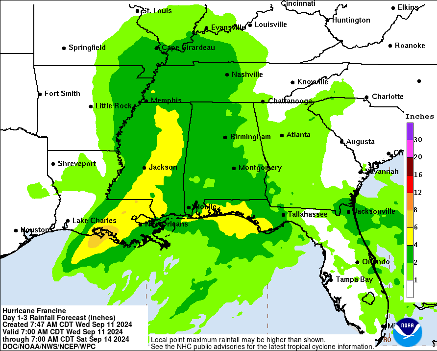
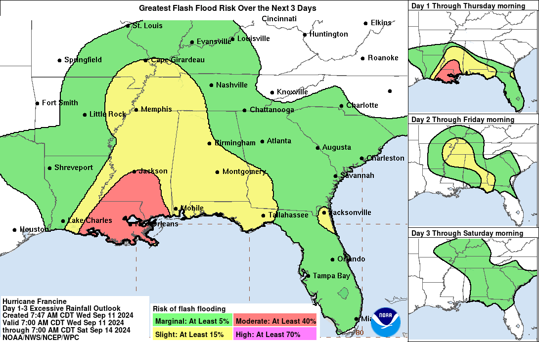
RAINFALL: Francine is expected to bring storm total rainfall of 4 to 8 inches, with local amounts to 12 inches across southeastern Louisiana, Mississippi, far southern Alabama and the Florida Panhandle through Thursday night. This rainfall could lead to considerable flash, urban and river flooding.
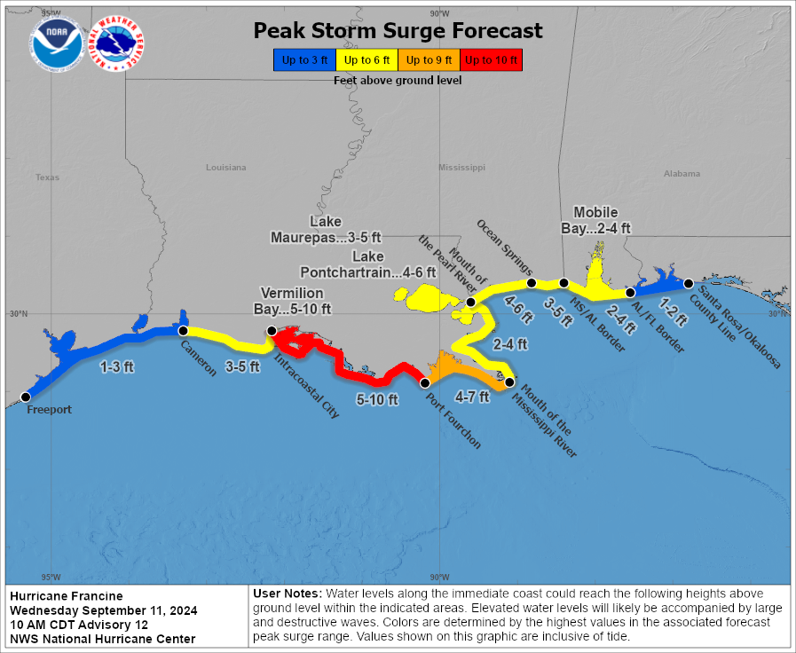
STORM SURGE: The combination of a dangerous storm surge and the tide will cause normally dry ar-eas near the coast to be flooded by rising waters moving inland from the shoreline. The water could reach the following heights above ground somewhere in the indicated areas if the peak surge occurs at the time of high tide...
Intracoastal City, LA to Port Fourchon, LA...5-10 ft
Vermilion Bay...5-10 ft
Port Fourchon, LA to Mouth of the Mississippi River, LA...4-7 ft
Mouth of the Pearl River, LA to Ocean Springs, MS...4-6 ft
Lake Pontchartrain...4-6 ft
Ocean Springs, MS to MS/AL Border...3-5 ft
Cameron, LA to Intracoastal City, LA...3-5 ft
Lake Maurepas...3-5 ft
The deepest water will occur along the immediate coast near and to the east of the landfall location, where the surge will be accompanied by large and dangerous waves. Surge-related flooding depends on the relative timing of the surge and the tidal cycle, and can vary greatly over short distances. Storm surge is not expected to pose a threat to the risk reduction system levees. However, there may be some overtopping of local levees. For information specific to your area, please see products issued by your local National Weather Service forecast office.
TORNADOES: A few tornadoes are possible today and tonight across parts of southeast Louisiana, southern Mississippi, southern Alabama, and the Florida Panhandle.
SURF: Swells generated by Francine are affecting much of the northern and northwestern Gulf Coast, likely causing life-threatening surf and rip current conditions. Please consult products from your local weather office.
Forecaster Beven


