
...EXPECTED TO BRING LIFE-THREATENING STORM SURGE, DAMAGING WINDS, AND FLOODING RAINS TO A LARGE PORTION OF FLORIDA AND THE SOUTHEASTERN UNITED STATES...
Hurricane Helene Advisory Number 9
NWS National Hurricane Center Miami FL AL092024
1000 AM CDT Wed Sep 25 2024
SUMMARY OF 1000 AM CDT...1500 UTC...INFORMATION
-----------------------------------------------
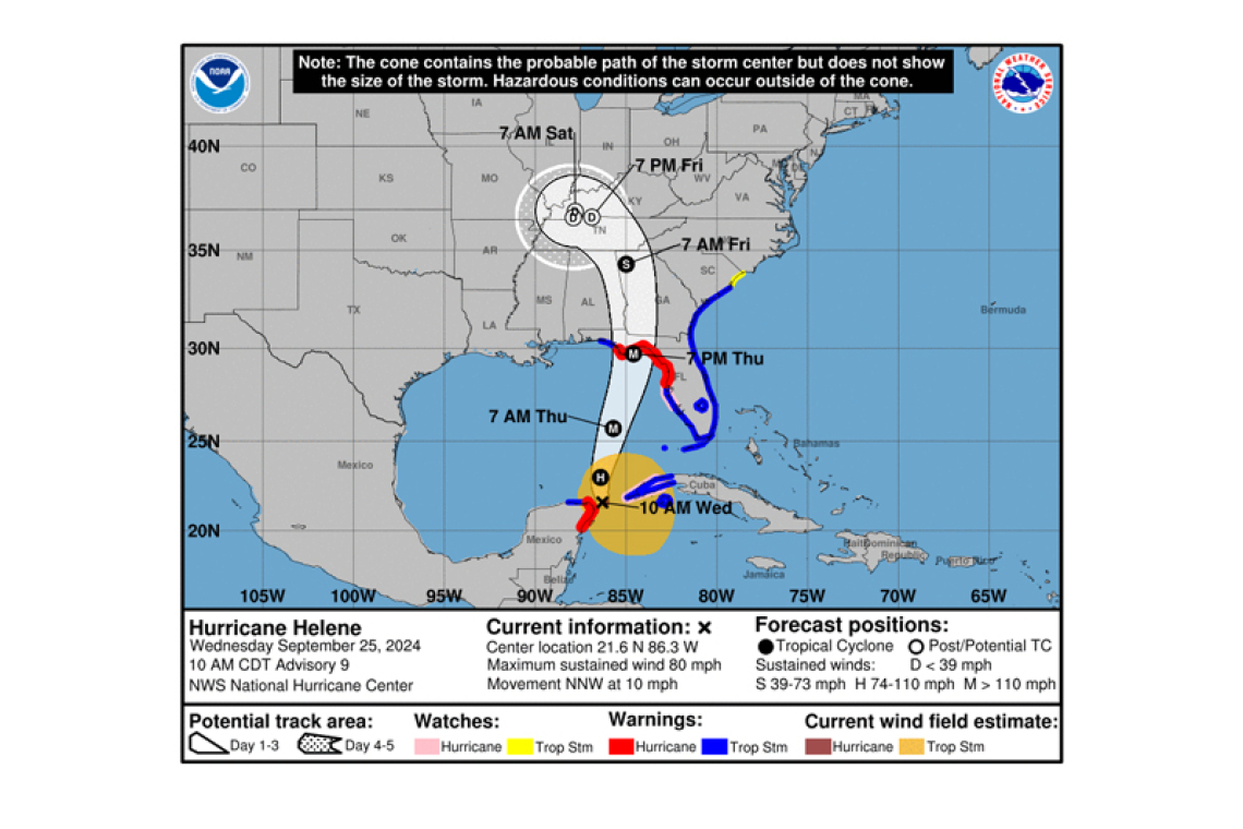
 LOCATION...21.6N 86.3W
ABOUT 85 MI...135 KM NNE OF COZUMEL MEXICO
ABOUT 500 MI...810 KM SSW OF TAMPA FLORIDA
MAXIMUM SUSTAINED WINDS...80 MPH...130 KM/H
PRESENT MOVEMENT...NNW OR 330 DEGREES AT 10 MPH...17 KM/H
MINIMUM CENTRAL PRESSURE...979 MB...28.91 INCHES
WATCHES AND WARNINGS
--------------------
 CHANGES WITH THIS ADVISORY:
The Tropical Storm Warning has been extended northward along the coasts of Georgia and South Carolina to South Santee River, and westward along the Florida Gulf coast to the Okaloosa/Walton County Line.
A Storm Surge Watch has been issued from Mexico Beach to Indian
Pass, Florida.
A Tropical Storm Watch has been issued along the coast of South Carolina north of South Santee River to Little River Inlet.
SUMMARY OF WATCHES AND WARNINGS IN EFFECT:
A Storm Surge Warning is in effect for...
* Indian Pass southward to Flamingo
* Tampa Bay
* Charlotte Harbor
A Hurricane Warning is in effect for...
* Anclote River to Mexico Beach
* Cabo Catoche to Tulum, Mexico including Cozumel
A Storm Surge Watch is in effect for...
* West of Indian Pass to Mexico Beach
A Hurricane Watch is in effect for...
* Cuban province of Pinar del Rio
* Englewood to Anclote River, including Tampa Bay
A Tropical Storm Warning is in effect for...
* Florida Keys, including the Dry Tortugas
* Flamingo to Anclote River, including Tampa Bay
* West of Mexico Beach to the Okaloosa/Walton County Line
* Flamingo northward to South Santee River
* Lake Okeechobee
* Rio Lagartos to Cabo Catoche, Mexico
* Cuban provinces of Artemisa, Pinar del Rio, and the Isle of Youth
A Tropical Storm Watch is in effect for...
* North of South Santee River to Little River Inlet
 A Storm Surge Warning means there is a danger of life-threatening inundation, from rising water moving inland from the coastline, during the next 36 hours in the indicated locations. This is a life-threatening situation. Persons located within these areas should take all necessary actions to protect life and property from rising water and the potential for other dangerous conditions. Prompt-ly follow evacuation and other instructions from local officials.
A Hurricane Warning means that hurricane conditions are expected somewhere within the warning area. A warning is typically issued 36 hours before the anticipated first occurrence of tropi-cal-storm-force winds, conditions that make outside preparations difficult or dangerous. Preparations to protect life and property should be rushed to completion.
A Tropical Storm Warning means that tropical storm conditions are expected somewhere within the warning area within the next 36 hours.
A Storm Surge Watch means there is a possibility of life-threatening inundation, from rising water moving inland from the coastline, in the indicated locations during the next 48 hours.
A Hurricane Watch means that hurricane conditions are possible within the watch area. A watch is typically issued 48 hours before the anticipated first occurrence of tropical-storm-force winds, condi-tions that make outside preparations difficult or dangerous.
A Tropical Storm Watch means that tropical storm conditions are possible within the watch area.
Additional watches or warnings may be required later today.
For storm information specific to your area in the United States, including possible inland watches and warnings, please monitor products issued by your local National Weather Service forecast office. For
storm information specific to your area outside of the United States, please monitor products issued by your national meteorological service.
DISCUSSION AND OUTLOOK
----------------------
At 1000 AM CDT (1500 UTC), the center of Hurricane Helene was located near latitude 21.6 North, longitude 86.3 West. Helene is moving toward the north-northwest near 10 mph (17 km/h). A turn toward the north and north-northeast with an increase in forward speed is expected later today through Thursday, bringing the center of Helene across the eastern Gulf of Mexico and to the Florida Big Bend coast by Thursday evening. After landfall, Helene is expected to slow down and turn toward the northwest over the southeastern United States Friday and Saturday.
Data from NOAA and Air Force Reserve Hurricane Hunter aircraft indicate that maximum sustained winds have increased to near 80 mph (130 km/h) with higher gusts. Additional strengthening is fore-cast, and Helene is expected to be a major hurricane when it reaches the Florida Big Bend coast Thursday evening. Weakening is expected after landfall, but Helene's fast forward speed will allow strong, damaging winds, especially in gusts, to penetrate well inland across the southeastern United States, including over the higher terrain of the southern Appalachians.
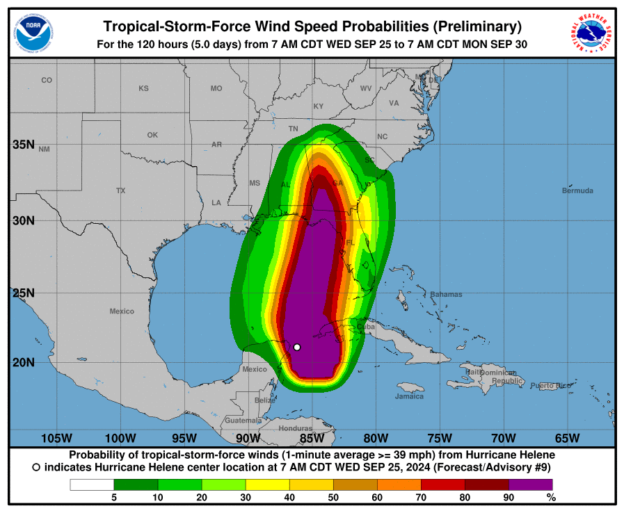
Hurricane-force winds extend outward up to 25 miles (35 km) from the center and tropi-cal-storm-force winds extend outward up to 275 miles (445 km).
The minimum central pressure based on dropsonde is 979 mb (28.91 inches).
HAZARDS AFFECTING LAND
----------------------
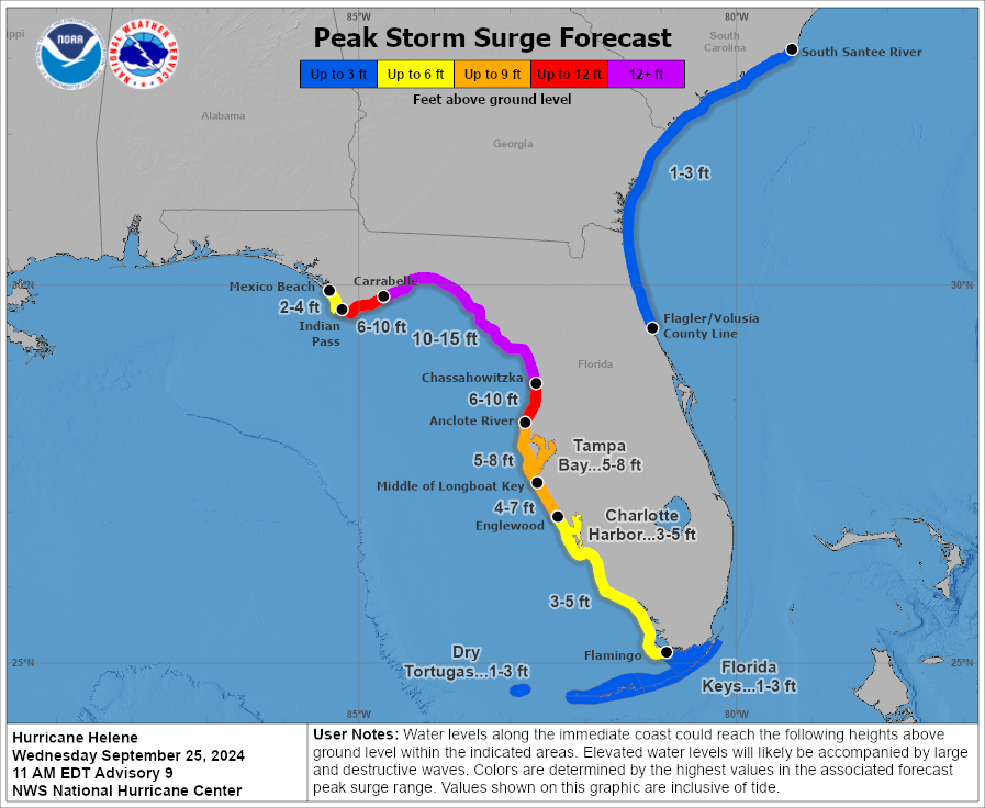
STORM SURGE: The combination of a dangerous storm surge and the tide will cause normally dry ar-eas near the coast to be flooded by rising waters moving inland from the shoreline. The water could reach the following heights above ground somewhere in the indicated areas if the peak surge occurs at the time of high tide...
Carrabelle, FL to Chassahowitzka, FL...10-15 ft
Chassahowitzka, FL to Anclote River, FL...6-10 ft
Indian Pass, FL to Carrabelle, FL...6-10 ft
Anclote River, FL to Middle of Longboat Key, FL...5-8 ft
Tampa Bay...5-8 ft
Middle of Longboat Key, FL to Englewood, FL...4-7 ft
Englewood, FL to Flamingo, FL...3-5 ft
Charlotte Harbor...3-5 ft
Storm surge could raise water levels by as much as 2 to 4 feet above normal tide levels in areas of onshore winds along the southern coast of Pinar del Rio, Cuba, including the Isle of Youth.
Storm surge could raise water levels by as much as 2 to 4 feet above ground level in areas of onshore winds within the warning area along the east coast of the Yucatan Peninsula.
WIND: Hurricane conditions are expected within the U.S. hurricane warning area late Thursday, with tropical storm conditions beginning Thursday morning. Tropical storm conditions are expected in southern Florida later today and will spread northward across the rest of Florida, Georgia, and South Carolina through Thursday. Tropical storm conditions are possible within the tropical storm watch area in South Carolina beginning on Thursday.
Hurricane conditions, especially in gusts, are expected in the hurricane warning area in Mexico during the next several hours. Tropical storm conditions are occurring in the warning area in Cuba, and hur-ricane conditions are possible for the western portion of Cuba today.
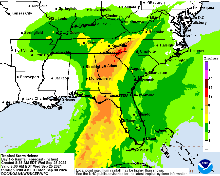
RAINFALL: Helene is expected to produce total rain accumulations of 4 to 8 inches over western Cuba, the Cayman Islands, and the northeast Yucatan Peninsula, with isolated totals around 12 inches. This rainfall brings a risk of considerable flooding.
Over the Southeastern U.S. into the Southern Appalachians, Helene is expected to produce total rain accumulations of 5 to 10 inches with isolated totals around 15 inches. This rainfall will likely result in areas of considerable flash and urban flooding, with areas of significant river flooding. Landslides are possible in areas of steep terrain in the southern Appalachians.
TORNADOES: A tornado or two may occur tonight over parts of the Florida Peninsula and southern Alabama. The risk of tornadoes will increase on Thursday, expanding northward across Florida into parts of Georgia and South Carolina.
SURF: Swells generated by Helene will affect the southern coast of Cuba and the Yucatan Peninsula of Mexico during the next couple of days. Swells will spread northward toward the west coast of Florida and the northeastern Gulf Coast later today and Thursday. These swells are likely to cause life-threatening surf and rip current conditions. Please consult products from your local weather of-fice.
Forecaster Berg


