
Hurricane Marco Advisory Number 14
NWS National Hurricane Center Miami FL AL142020
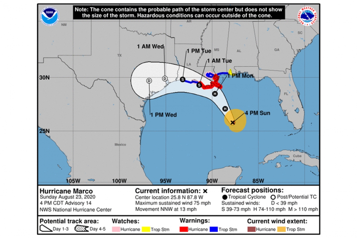
400 PM CDT Sun Aug 23 2020
SUMMARY OF 400 PM CDT...2100 UTC...INFORMATION
----------------------------------------------
LOCATION...25.8N 87.8W
ABOUT 240 MI...390 KM SSE OF THE MOUTH OF THE MISSISSIPPI RIVER
ABOUT 395 MI...640 KM SE OF LAFAYETTE LOUISIANA
MAXIMUM SUSTAINED WINDS...75 MPH...120 KM/H
PRESENT MOVEMENT...NNW OR 340 DEGREES AT 13 MPH...20 KM/H
MINIMUM CENTRAL PRESSURE...991 MB...29.27 INCHES
WATCHES AND WARNINGS
--------------------
CHANGES WITH THIS ADVISORY:
A Tropical Storm Warning has been issued from Cameron to west of Morgan City, Louisiana.
SUMMARY OF WATCHES AND WARNINGS IN EFFECT:
A Storm Surge Warning is in effect for....
* Morgan City Louisiana to Ocean Springs Mississippi
* Lake Borgne
A Hurricane Warning is in effect for...
* Morgan City Louisiana to the Mouth of the Pearl River
A Storm Surge Watch is in effect for...
* Sabine Pass to Morgan City Louisiana
* Ocean Springs Mississippi to the Mississippi/Alabama border
* Lake Pontchartrain and Lake Maurepas
A Hurricane Watch is in effect for...
* Intracoastal City to west of Morgan City
* Lake Pontchartrain, Lake Maurepas, and Metropolitan New Orleans
A Tropical Storm Warning is in effect for...
* Mouth of the Pearl River to the Mississippi/Alabama border
* Lake Pontchartrain, Lake Maurepas, and Metropolitan New Orleans
* Cameron to west of Morgan City
A Tropical Storm Watch is in effect for...
* Mississippi/Alabama border to the Alabama/Florida border
DISCUSSION AND OUTLOOK
----------------------
At 400 PM CDT (2100 UTC), the center of Hurricane Marco was located near latitude 25.8 North, longitude 87.8 West. Marco is moving toward the north-northwest near 13 mph (20 km/h), a turn to the northwest is expected later tonight followed by a turn to the west-northwest by Monday night. On the forecast track, Marco will be near the Louisiana coast Monday afternoon, and move near or over the coast through Tuesday.
Maximum sustained winds are near 75 mph (120 km/h) with higher gusts. Little change is strength is expected over the next 24 hrs. Gradual weakening is expected thereafter, and Marco could become a
remnant low by Tuesday night.
Hurricane-force winds extend outward up to 15 miles (30 km) from the center and tropical-storm-force winds extend outward up to 105 miles (165 km).
The estimated minimum central pressure is 991 mb (29.27 inches).
HAZARDS AFFECTING LAND
----------------------
STORM SURGE: The combination of a dangerous storm surge and the tide will cause normally dry areas near the coast to be flooded by rising waters moving inland from the shoreline. The water could reach the following heights above ground somewhere in the indicated areas if the peak surge occurs at the time of high tide...
Morgan City LA to Mouth of the Mississippi River...4-6 ft
Mouth of the Mississippi River to Ocean Springs MS including Lake Borgne...3-5 ft
Lake Pontchartrain and Lake Maurepas...2-4 ft
Intracoastal City LA to Morgan City LA...2-4 ft
Sabine Pass to Intracoastal City...1-3 ft
Ocean Springs MS to the AL/FL Border including Mobile Bay...1-3 ft
The deepest water will occur along the immediate coast in areas of onshore winds, where the surge will be accompanied by large and dangerous waves. Surge-related flooding depends on the relative timing of the surge and the tidal cycle, and can vary greatly over short distances. For information specific to your area, please see products issued by your local National Weather Service forecast
office.
WIND: Hurricane conditions are expected within the hurricane warning area by midday Monday, with tropical storm conditions possible by early Monday. Tropical storm conditions are possible within the tropical storm watch area on Monday, and hurricane conditions are possible within the hurricane watch areas late Monday.
RAINFALL: Marco is expected to produce total rainfall accumulations of 3 to 5 inches with isolated maximum amounts of 7 inches across the Central U.S. Gulf coast through Tuesday.
This rainfall may result in scattered areas of flash and urban flooding along the Central U.S. Gulf Coast.
SURF: Swells generated by Marco are likely to affect portions of the northern Gulf Coast for the next couple of days. These swells are likely to cause life-threatening surf and rip current conditions. Please consult products from your local weather office.
TORNADOES: An isolated tornado is possible early Monday morning near the southeast Louisiana coast. Isolated tornadoes are possible across southeast Louisiana, southern Mississippi, southern Alabama, and the Florida Panhandle Monday and Monday night.


