
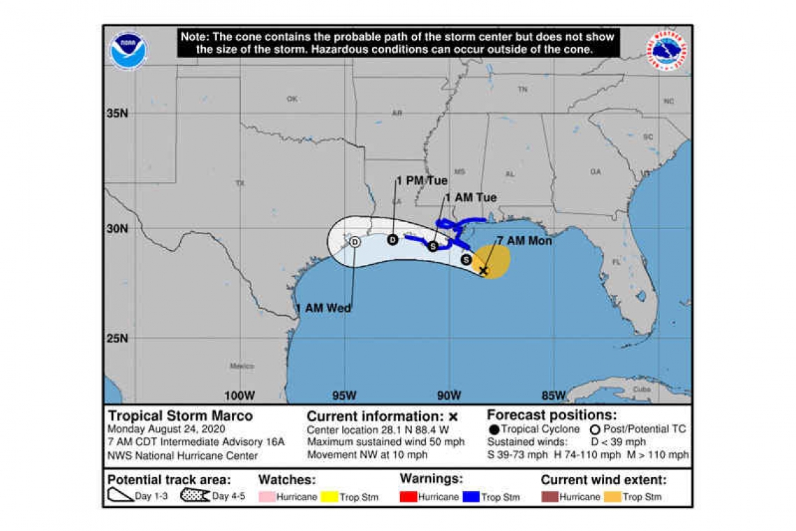
Tropical Storm Marco Intermediate Advisory Number 16A
NWS National Hurricane Center Miami FL AL142020
700 AM CDT Mon Aug 24 2020
SUMMARY OF 700 AM CDT...1200 UTC...INFORMATION
----------------------------------------------
LOCATION...28.1N 88.4W
ABOUT 85 MI...135 KM SSE OF THE MOUTH OF THE MISSISSIPPI RIVER
MAXIMUM SUSTAINED WINDS...50 MPH...80 KM/H
PRESENT MOVEMENT...NW OR 325 DEGREES AT 10 MPH...17 KM/H
MINIMUM CENTRAL PRESSURE...1005 MB...29.68 INCHES
WATCHES AND WARNINGS
--------------------
CHANGES WITH THIS ADVISORY:
None.
SUMMARY OF WATCHES AND WARNINGS IN EFFECT:
A Storm Surge Warning is in effect for....
* Morgan City Louisiana to Ocean Springs Mississippi
* Lake Borgne
A Tropical Storm Warning is in effect for...
* Intracoastal City to the Mississippi/Alabama border
* Lake Pontchartrain, Lake Maurepas, and Metropolitan New Orleans
A Storm Surge Warning means there is a danger of life-threatening inundation, from rising water moving inland from the coastline, during the next 36 hours in the indicated locations. This is a life-threatening situation. Persons located within these areas should take all necessary actions to protect life and property from rising water and the potential for other dangerous conditions. Promptly follow evacuation and other instructions from local officials.
A Tropical Storm Warning means that tropical storm conditions are expected somewhere within the warning area, in this case within 12 to 24 hours.
DISCUSSION AND OUTLOOK
----------------------
At 700 AM CDT (1200 UTC), the center of Tropical Storm Marco was located near latitude 28.1 North, longitude 88.4 West. Marco is moving toward the northwest near 10 mph (17 km/h). Marco is forecast to approach the coast of Louisiana this afternoon, and then turn westward and move very close to the coast of Louisiana through Tuesday night.
Data from an Air Force Reserve Hurricane Hunter aircraft indicate that maximum sustained winds have decreased to near 50 mph (80 km/h) with higher gusts. Further weakening is expected, and Marco is forecast to become a tropical depression late on Tuesday and dissipate on Wednesday.
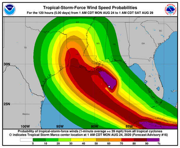
Tropical-storm-force winds extend outward up to 105 miles (165 km), primarily northeast of the center.
The estimated minimum central pressure is 1005 mb (29.68 inches).
HAZARDS AFFECTING LAND
----------------------
STORM SURGE: The combination of a dangerous storm surge and the tide will cause normally dry areas near the coast to be flooded by rising waters moving inland from the shoreline. The water could reach the following heights above ground somewhere in the indicated areas if the peak surge occurs at the time of high tide...
Morgan City LA to Ocean Springs MS, including Lake Borgne...2-4 ft
The deepest water will occur along the immediate coast in areas of onshore winds, where the surge will be accompanied by large and dangerous waves. Surge-related flooding depends on the relative timing of the surge and the tidal cycle, and can vary greatly over short distances. For information specific to your area, please see products issued by your local National Weather Service forecast office.
WIND: Tropical storm conditions are expected to start by this afternoon in portions of the warning area.
RAINFALL: Marco is expected to produce total rainfall accumulations of 3 to 5 inches with isolated maximum amounts of 10 inches across portions of the northeast and north-central Gulf coast through Tuesday. This rainfall may result in areas of flash, urban and small stream flooding in the area.
SURF: Swells generated by Marco are likely to affect portions of the northern Gulf Coast for the next couple of days. These swells are likely to cause life-threatening surf and rip current conditions. Please consult products from your local weather office.
TORNADOES: A couple of tornadoes will be possible today from southeast Louisiana to the western Florida Panhandle.
Forecaster Latto


