OF SOUTHEASTERN NORTH CAROLINA...
Potential Tropical Cyclone Eight Intermediate Advisory Number 3A
NWS National Hurricane Center Miami FL AL082024
800 AM EDT Mon Sep 16 2024
SUMMARY OF 800 AM EDT...1200 UTC...INFORMATION
----------------------------------------------
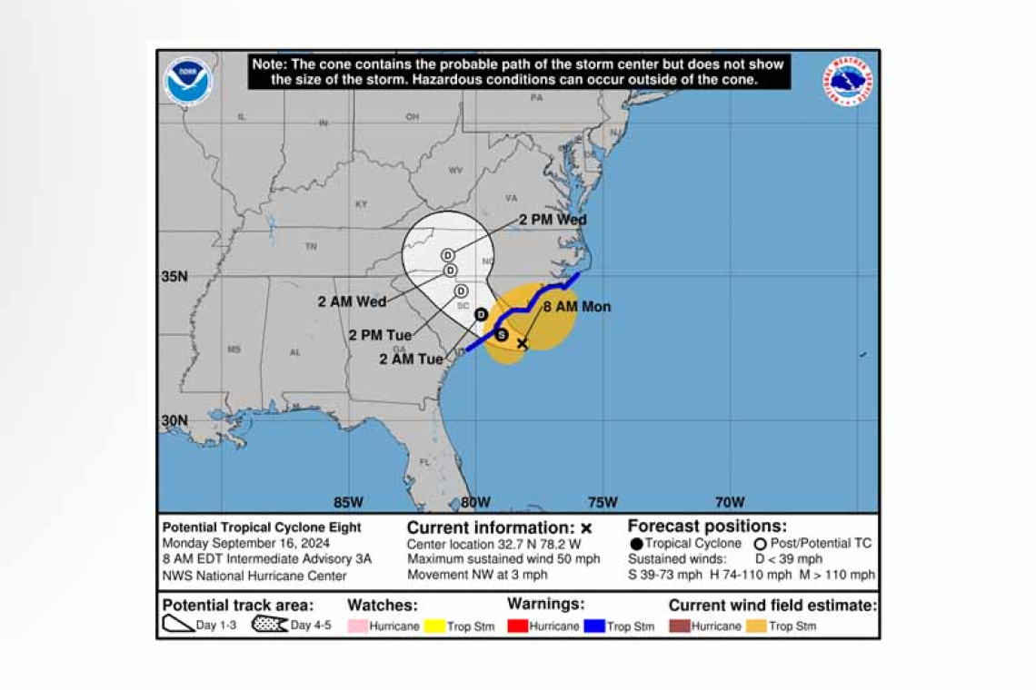
LOCATION...32.7N 78.2W
ABOUT 85 MI...140 KM S OF CAPE FEAR NORTH CAROLINA
ABOUT 100 MI...160 KM E OF CHARLESTON SOUTH CAROLINA
MAXIMUM SUSTAINED WINDS...50 MPH...85 KM/H
PRESENT MOVEMENT...NW OR 325 DEGREES AT 3 MPH...6 KM/H
MINIMUM CENTRAL PRESSURE...1005 MB...29.68 INCHES
WATCHES AND WARNINGS
--------------------
 CHANGES WITH THIS ADVISORY:
None.
SUMMARY OF WATCHES AND WARNINGS IN EFFECT:
A Tropical Storm Warning is in effect for...
* Edisto Beach, South Carolina northward to Ocracoke Inlet, North Carolina
A Tropical Storm Warning means that tropical storm conditions are expected somewhere within the warning area, in this case within the next 12 hours.
For storm information specific to your area, including possible inland watches and warnings, please monitor products issued by your local National Weather Service forecast office.
DISCUSSION AND OUTLOOK
----------------------
 At 800 AM EDT (1200 UTC), the disturbance was centered near latitude 32.7 North, longitude 78.2 West. The system is moving toward the northwest near 3 mph (6 km/h). A faster motion toward the northwest or north-northwest is expected today and Tuesday, followed by a gradual turn toward the north by Wednesday. On the forecast track, the low will reach the coast of South Carolina this after-noon and then move inland across the Carolinas tonight through Wednesday.
Maximum sustained winds are near 50 mph (85 km/h) with higher gusts. Little change in strength is expected before the system reaches the coast, and the low still has a chance of becoming a tropical or
subtropical storm. Weakening is forecast after the system moves inland, and it is likely to dissipate over the Carolinas by late Wednesday.
* Formation chance through 48 hours...medium...60 percent.
* Formation chance through 7 days...medium...60 percent.
 Tropical-storm-force winds extend outward up to 175 miles (280 km) from the center. Doppler radar data and surface observations indicate strong winds are nearing the coast and will spread onshore during the next few hours. NOAA buoy 41013 at Frying Pan Shoals, North Carolina recently reported a sustained wind of 47 mph (76 km/h) and a gust of 56 mph (91 km/h). NOAA buoy 41037 offshore of Wrightsville Beach, North Carolina recently reported a sustained wind of 38 mph (61 km/h) and a gust of 54 mph (87 km/h).
The estimated minimum central pressure is 1005 mb (29.68 inches).
HAZARDS AFFECTING LAND
----------------------
WIND: Tropical storm conditions are expected within the warning area through late this afternoon or evening.
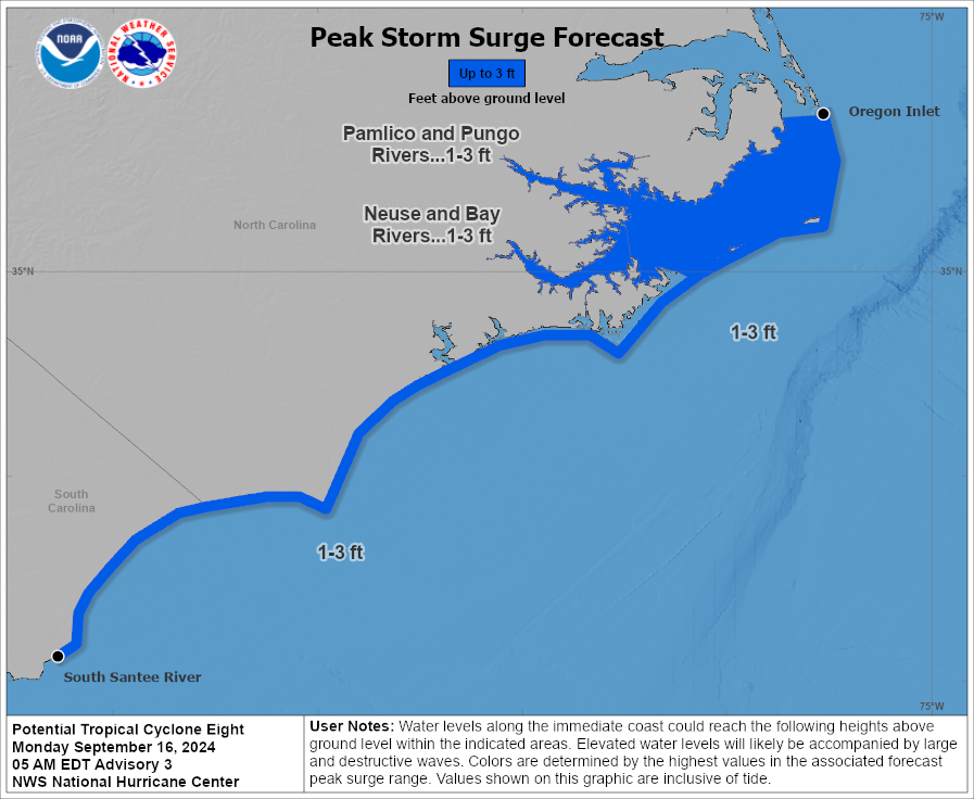
STORM SURGE: The combination of a storm surge and the tide will cause normally dry areas near the coast to be flooded by rising waters moving inland from the shoreline. The water could reach the fol-lowing heights above ground somewhere in the indicated areas if the peak surge occurs at the time of high tide...
South Santee River, SC to Oregon Inlet, NC... 1-3 ft
Neuse and Bay Rivers, NC... 1-3 ft
Pamlico and Pungo Rivers, NC... 1-3 ft
The deepest water will occur along the immediate coast near and to the east of
the landfall location, where the surge will be accompanied by large and dangerous waves. Surge-related flooding depends on the relative timing of the surge and the tidal cycle, and can vary greatly over short distances. For information specific to your area, please see products issued by your local National Weather Service forecast office.
 RAINFALL: Potential Tropical Cyclone Eight will bring 4 to 8 inches of rainfall, with isolated totals near 10 inches, across portions of northeast South Carolina into southeast North Carolina today into to-night. Across the remainder of North Carolina, 2 to 4 inches of rainfall, with isolated totals near 6 inches, are expected through Tuesday. Over much of Virginia, 1 to 3 inches of rainfall, with locally higher amounts, are expected tonight through Wednesday. This rainfall could lead to a risk of flash and urban flooding and minor river flooding.
TORNADOES: A couple of tornadoes may occur through this evening
across the eastern Carolinas.
SURF: Swells are forecast to affect portions of the coast of the southeastern United States during the next couple of days. These swells are likely to cause life-threatening surf and rip current conditions. Please consult products from your local weather office.
Forecaster Reinhart


