
...THE TIME TO PREPARE, INCLUDING EVACUATE IF TOLD DO SO, IS QUICKLY COMING TO AN END ALONG THE FLORIDA WEST COAST...
Hurricane Milton Advisory Number 18
NWS National Hurricane Center Miami FL AL142024
1100 AM EDT Wed Oct 09 2024
SUMMARY OF 1100 AM EDT...1500 UTC...INFORMATION
-----------------------------------------------
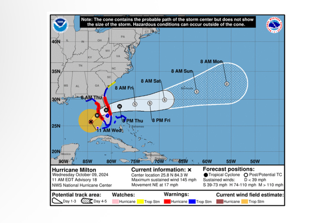
 LOCATION...25.8N 84.3W
ABOUT 160 MI...255 KM WSW OF FT. MYERS FLORIDA
ABOUT 190 MI...305 KM SW OF TAMPA FLORIDA
MAXIMUM SUSTAINED WINDS...145 MPH...230 KM/H
PRESENT MOVEMENT...NE OR 35 DEGREES AT 17 MPH...28 KM/H
MINIMUM CENTRAL PRESSURE...931 MB...27.50 INCHES
WATCHES AND WARNINGS
--------------------
CHANGES WITH THIS ADVISORY:
None.
SUMMARY OF WATCHES AND WARNINGS IN EFFECT:
 A Storm Surge Warning is in effect for...
* Florida west coast from Flamingo northward to Yankeetown, including Charlotte Harbor and Tampa Bay
* Sebastian Inlet Florida to Altamaha Sound Georgia, including the St. Johns River
A Hurricane Warning is in effect for...
* Florida west coast from Bonita Beach northward to Suwannee River, including Tampa Bay
* Florida east coast from the St. Lucie/Martin County Line northward to Ponte Vedra Beach
A Storm Surge Watch is in effect for...
* North of Altamaha Sound Georgia to Edisto Beach South Carolina
A Hurricane Watch is in effect for...
* Dry Tortugas
* Lake Okeechobee
* Florida west coast from Chokoloskee to south of Bonita Beach
* Florida east coast north of Ponte Vedra Beach to the mouth of the St. Marys River
* Florida east coast from the St. Lucie/Martin County Line to the Palm Beach/Martin County Line
A Tropical Storm Warning is in effect for...
* Florida Keys, including Dry Tortugas and Florida Bay
* Lake Okeechobee
* Florida west coast from Flamingo to south of Bonita Beach
* Florida west coast from north of Suwanee River to Indian Pass
* Florida east coast south of the St. Lucie/Martin County Line to Flamingo
* North of Ponte Vedra Beach Florida to the Savannah River
* Extreme northwestern Bahamas, including Grand Bahama Island, the Abacos, and Bimini
A Tropical Storm Watch is in effect for...
* North of the Savannah River to South Santee River South Carolina
 A Storm Surge Warning means there is a danger of life-threatening inundation, from rising water moving inland from the coastline, during the next 36 hours in the indicated locations. This is a life-threatening situation. Persons located within these areas should take all necessary actions to protect life and property from rising water and the potential for other dangerous conditions. Prompt-ly follow evacuation and other instructions from local officials.
A Hurricane Warning means that hurricane conditions are expected somewhere within the warning area. A warning is typically issued 36 hours before the anticipated first occurrence of tropi-cal-storm-force winds, conditions that make outside preparations difficult or dangerous. Preparations to protect life and property should be rushed to completion.
A Tropical Storm Warning means that tropical storm conditions are expected somewhere within the warning area within 36 hours.
A Storm Surge Watch means there is a possibility of life-threatening inundation, from rising water moving inland from the coastline, in the indicated locations during the next 48 hours.
A Hurricane Watch means that hurricane conditions are possible within the watch area. A watch is typically issued 48 hours before the anticipated first occurrence of tropical-storm-force winds, condi-tions that make outside preparations difficult or dangerous.
A Tropical Storm Watch means that tropical storm conditions are possible within the watch area, generally within 48 hours.
For storm information specific to your area in the United States, including possible inland watches and warnings, please monitor products issued by your local National Weather Service forecast office. For storm information specific to your area outside of the United States, please monitor products issued by your national meteorological service.
DISCUSSION AND OUTLOOK
----------------------
 At 1100 AM EDT (1500 UTC), the center of Hurricane Milton was located near latitude 25.8 North, longitude 84.3 West. Milton is moving toward the northeast near 17 mph (28 km/h). A northeastward motion with some decrease in forward speed is expected through this evening. A turn toward the east-northeast and east is expected on Thursday and Friday. On the forecast track, the center of Mil-ton will move across the eastern Gulf of Mexico today, make landfall along the west-central coast of Florida tonight, and move off the east coast of Florida over the western Atlantic Ocean on Thursday.
Maximum sustained winds are near 145 mph (230 km/h) with higher gusts. Milton is a category 4 hurricane on the Saffir-Simpson Hurricane Wind Scale. Milton is expected to remain an extremely dangerous major hurricane when it reaches the west-central coast of Florida tonight, and remain at hurricane strength while it moves across the Florida peninsula through Thursday. Gradual weakening is forecast while Milton moves eastward over the western Atlantic, and it is likely to become an extra-tropical storm by early Friday.
Hurricane-force winds extend outward up to 35 miles (55 km) from the center and tropi-cal-storm-force winds extend outward up to 175 miles (280 km). A NOAA saildrone (SD-1083) located approximately 80 miles northeast of the center recently reported a sustained wind of 44 mph (71 km/h) with a gust of 57 mph (91 km/h).
The minimum central pressure based on Air Force Reserve Hurricane Hunter data is 931 mb (27.50 inches).
HAZARDS AFFECTING LAND
----------------------
STORM SURGE: The combination of a dangerous storm surge and the tide will cause normally dry ar-eas near the coast to be flooded by rising waters moving inland from the shoreline. The water could reach the following heights above ground somewhere in the indicated areas if the peak surge occurs at the time of high tide...
Anna Maria Island, FL to Boca Grande, FL...10-15 ft
Anclote River, FL to Anna Maria Island, FL...8-12 ft
Tampa Bay...8-12 ft
Boca Grande, FL to Bonita Beach, FL...8-12 ft
Charlotte Harbor...8-12 ft
Bonita Beach, FL to Chokoloskee, FL...5-8 ft
Aripeka, FL to Anclote River, FL...3-5 ft
Chokoloskee, FL to Flamingo, FL...3-5 ft
Sebastian Inlet, FL to Altamaha Sound, GA...3-5 ft
Altamaha Sound, GA to Edisto Beach, SC...2-4 ft
Yankeetown, FL to Aripeka, FL...2-4 ft
Dry Tortugas...2-4 ft
St. Johns River...2-4 ft
The deepest water will occur along the immediate coast near and to the south of the landfall location, where the surge will be accompanied by large and dangerous waves. Surge-related flooding depends on the relative timing of the surge and the tidal cycle, and can vary greatly over short distances. For information specific to your area, please see products issued by your local National Weather Service forecast office.
RAINFALL: Rainfall amounts of 6 to 12 inches, with localized totals up to 18 inches, are expected across central to northern portions of the Florida Peninsula through Thursday. This rainfall brings the risk of catastrophic and life-threatening flash and urban flooding, along with moderate to major river flooding.
WIND: Hurricane conditions are expected in the hurricane warning area across Florida beginning this evening through Thursday morning and are possible in the hurricane watch area on Thursday. Tropical storm conditions are expected to begin in the warning area on the west coast of Florida in a few hours, spreading across the peninsula and reaching the east coast tonight. Tropical storm conditions are ex-pected to begin in the warning area along the Georgia coast on Thursday.
Tropical storm conditions are expected in portions of the northwestern Bahamas on Thursday.
Tropical storm conditions are possible within the watch area on the South Carolina coast on Thursday.
TORNADOES: Several tornadoes are likely today and tonight across
parts of central and southern Florida.
SURF: Swells generated by Milton are expected to continue to affect much of the Gulf Coast and will increase along the southeastern U.S. coast during the next day or two. These swells are likely to cause life-threatening surf and rip current conditions. Please consult products from your local weather of-fice.
Forecaster Berg


