NWS National Hurricane Center Miami FL AL032020
400 PM CDT Sun Jun 07 2020
...TROPICAL-STORM-FORCE WINDS LASHING THE GULF COAST FROM SOUTHEASTERN LOUISIANA EASTWARD TO MISSISSIPPI AND ALABAMA...
...HEAVY RAINFALL AND STORM SURGE TO CONTINUE FROM SOUTHEASTERN LOUISIANA EASTWARD TO THE FLORIDA PANHANDLE...
SUMMARY OF 400 PM CDT...2100 UTC...INFORMATION
----------------------------------------------
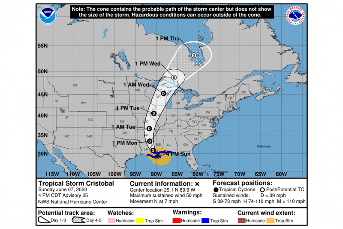
LOCATION...29.1N 89.9W
ABOUT 65 MI...100 KM S OF NEW ORLEANS LOUISIANA
MAXIMUM SUSTAINED WINDS...50 MPH...85 KM/H
PRESENT MOVEMENT...N OR 355 DEGREES AT 7 MPH...11 KM/H
MINIMUM CENTRAL PRESSURE...993 MB...29.32 INCHES
WATCHES AND WARNINGS
--------------------
CHANGES WITH THIS ADVISORY:
None.
SUMMARY OF WATCHES AND WARNINGS IN EFFECT:
A Storm Surge Warning is in effect for...
* Mouth of the Mississippi River to Ocean Springs Mississippi
* Lake Borgne
A Storm Surge Watch is in effect for...
* East of Morgan City Louisiana to the mouth of the Mississippi River
A Tropical Storm Warning is in effect for...
* Intracoastal City Louisiana to the Okaloosa/Walton County Florida line
* Lake Pontchartrain and Lake Maurepas
A Storm Surge Warning means there is a danger of life-threatening inundation, from rising water moving inland from the coastline, during the next 36 hours in the indicated locations. This is a life-threatening situation. Persons located within these areas should take all necessary actions to protect life and property from rising water and the potential for other dangerous conditions. Promptly follow evacuation and other instructions from local officials.
A Storm Surge Watch means there is a possibility of life-threatening inundation, from rising water moving inland from the coastline, in the indicated locations during the next 48 hours.
A Tropical Storm Warning means that tropical storm conditions are expected somewhere within the warning area within the next 24 hours.
DISCUSSION AND OUTLOOK
----------------------
At 400 PM CDT (2100 UTC), the center of Tropical Storm Cristobal was located near latitude 29.1 North, longitude 89.9 West. Cristobal is moving toward the north near 7 mph (11 km/h), and this general motion is expected to continue this afternoon, followed by a gradual turn toward the north-northwest later this evening and tonight. On the forecast track, the center of Cristobal will approach the northern Gulf of Mexico coast this afternoon, then move inland across southeastern Louisiana this afternoon through Monday morning, and northward across Arkansas and Missouri Monday afternoon into Tuesday.
Data from NOAA Doppler weather radars and offshore oil platforms indicate that maximum sustained winds remain 50 mph (85 km/h) with higher gusts. Little change in strength is forecast before landfall. Gradual weakening will begin once Cristobal moves inland.
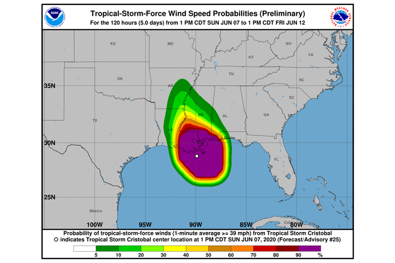
Tropical-storm-force winds extend outward up to 205 miles (335 km) from the center. During the past couple of hours, an oil rig located about 80 miles south of Mobile, Alabama, measured a sustained wind of 51 mph (82 km/h) and a gust to 64 mph (103 km/h) at an elevation of 123 ft. A NOAA automated observing station on Dauphin Island, Alabama, recently reported a sustained wind of 42 mph (68 km/h) and a gust to 48 mph (77 km/h), and a Weatherflow site on Ship Island, Mississippi, observed a sustained wind of 41 mph (66 km/h) and a gust to 51 mph (77 km/h).
The estimated minimum central pressure based on nearby surface observations is 993 mb (29.32 inches).
HAZARDS AFFECTING LAND
----------------------
STORM SURGE: The combination of a dangerous storm surge and the tide will cause normally dry areas near the coast to be flooded by rising waters moving inland from the shoreline. The water could reach the following heights above ground somewhere in the indicated areas if the peak surge occurs at the time of high tide...
Mouth of the Mississippi River to Ocean Springs MS including Lake Borgne...3-5 ft
Morgan City LA to Mouth of the Mississippi River...2-4 ft
Ocean Springs MS to Marco Island FL including Mobile Bay, Pensacola Bay, and Tampa Bay...1-3 ft
The deepest water will occur along the immediate coast in areas of onshore winds and will likely extend along the coast well to the east of the center. Surge-related flooding depends on the relative timing of the surge and the tidal cycle, and can vary greatly over short distances. For information specific to your area, please see products issued by your local National Weather Service forecast office.
WIND: Tropical storm conditions are expected within the Tropical Storm Warning area along the northern Gulf coast through tonight.
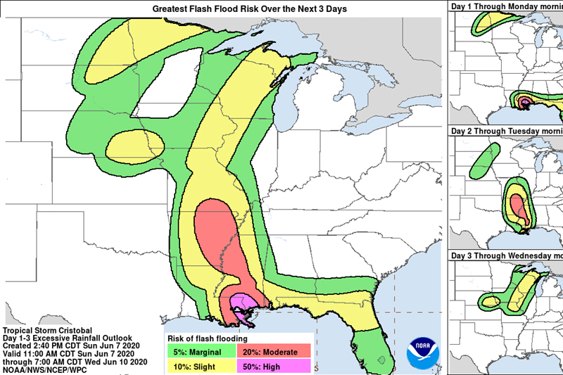
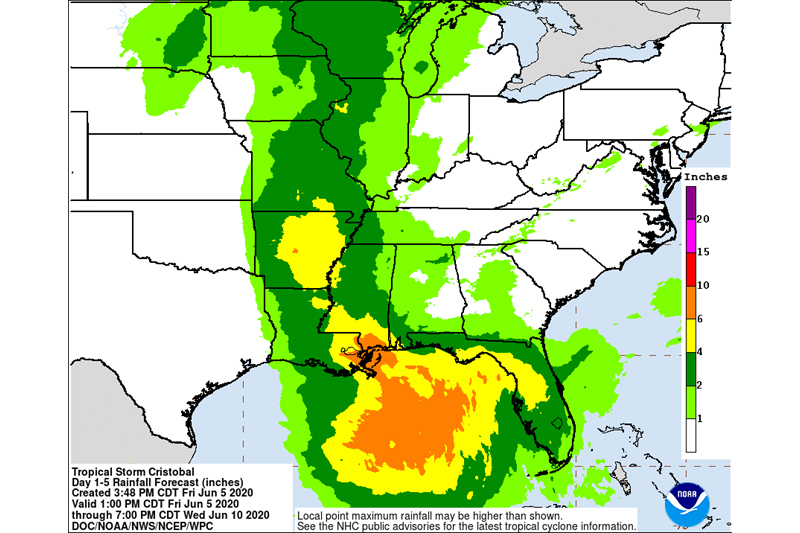
RAINFALL: Cristobal is expected to produce storm total rainfall accumulations of 4 to 8 inches across portions of the central to eastern Gulf Coast into the Lower Mississippi Valley, with isolated amounts to 12 inches. Rainfall totals of 2 to 4 inches with local amounts to 6 inches are expected across portions of the Mid to Upper Mississippi Valley and Northern Plains near and in advance of Cristobal. This rainfall will likely lead to flash flooding and widespread flooding on smaller streams across portions of the central Gulf Coast into the Lower Mississippi Valley. New and renewed significant river flooding is possible along the central
Gulf Coast and into the Mississippi Valley.
TORNADOES: A few tornadoes are possible today and tonight across eastern Louisiana, southern Mississippi, southern Alabama, and northern Florida.
SURF: Swells generated by Cristobal will affect portions of the northern and eastern Gulf coast during the next couple of days. These swells are likely to cause life-threatening surf and rip current conditions.