
...HURRICANE AND STORM SURGE WATCHES REMAIN IN EFFECT FOR PORTIONS
OF THE FLORIDA GULF COAST...
Tropical Storm Helene Advisory Number 5
NWS National Hurricane Center Miami FL AL092024
1100 AM EDT Tue Sep 24 2024
SUMMARY OF 1100 AM EDT...1500 UTC...INFORMATION
-----------------------------------------------
 LOCATION...19.5N 84.3W
ABOUT 180 MI...295 KM ESE OF COZUMEL MEXICO
ABOUT 170 MI...275 KM SSE OF THE WESTERN TIP OF CUBA
MAXIMUM SUSTAINED WINDS...45 MPH...75 KM/H
PRESENT MOVEMENT...NW OR 310 DEGREES AT 12 MPH...19 KM/H
MINIMUM CENTRAL PRESSURE...1000 MB...29.53 INCHES
WATCHES AND WARNINGS
--------------------
 CHANGES WITH THIS ADVISORY:
A Tropical Storm Warning has been issued for the Lower Florida Keys west of the Seven Mile Bridge and for the Dry Tortugas.
A Tropical Storm Watch has been issued for the Middle Florida Keys from the Seven Mile Bridge to the Channel 5 Bridge.
SUMMARY OF WATCHES AND WARNINGS IN EFFECT:
A Storm Surge Watch is in effect for...
* Indian Pass southward to Flamingo
* Tampa Bay
* Charlotte Harbor
A Hurricane Watch is in effect for...
* Cabo Catoche to Tulum, Mexico
* Cuban province of Pinar del Rio
* Englewood to Indian Pass
* Tampa Bay
A Tropical Storm Warning is in effect for...
* Dry Tortugas
* Lower Florida Keys west of the Seven Mile Bridge
* Grand Cayman
* Rio Lagartos to Tulum, Mexico
* Cuban provinces of Artemisa, Pinar del Rio, and the Isle of Youth
A Tropical Storm Watch is in effect for...
* Middle Florida Keys from the Seven Mile Bridge to the Channel 5 Bridge
* Flamingo to south of Englewood
* West of Indian Pass to Walton Bay County line
A Storm Surge Watch means there is a possibility of life-
threatening inundation, from rising water moving inland from the
coastline, in the indicated locations during the next 48 hours.
For a depiction of areas at risk, please see the National Weather
Service Storm Surge Watch/Warning Graphic, available at
hurricanes.gov.
 A Tropical Storm Warning means that tropical storm conditions are expected somewhere within the warning area within the next 36 hours.
A Hurricane Watch means that hurricane conditions are possible within the watch area. A watch is typically issued 48 hours before the anticipated first occurrence of tropical-storm-force winds, condi-tions that make outside preparations difficult or dangerous.
A Tropical Storm Watch means that tropical storm conditions are possible within the watch area, generally within 48 hours.
Wind and storm surge warnings will likely be required for the U.S. later today.
For storm information specific to your area in the United States, including possible inland watches and warnings, please monitor products issued by your local National Weather Service forecast office. For storm information specific to your area outside of the United States, please monitor products issued by
your national meteorological service.
DISCUSSION AND OUTLOOK
----------------------
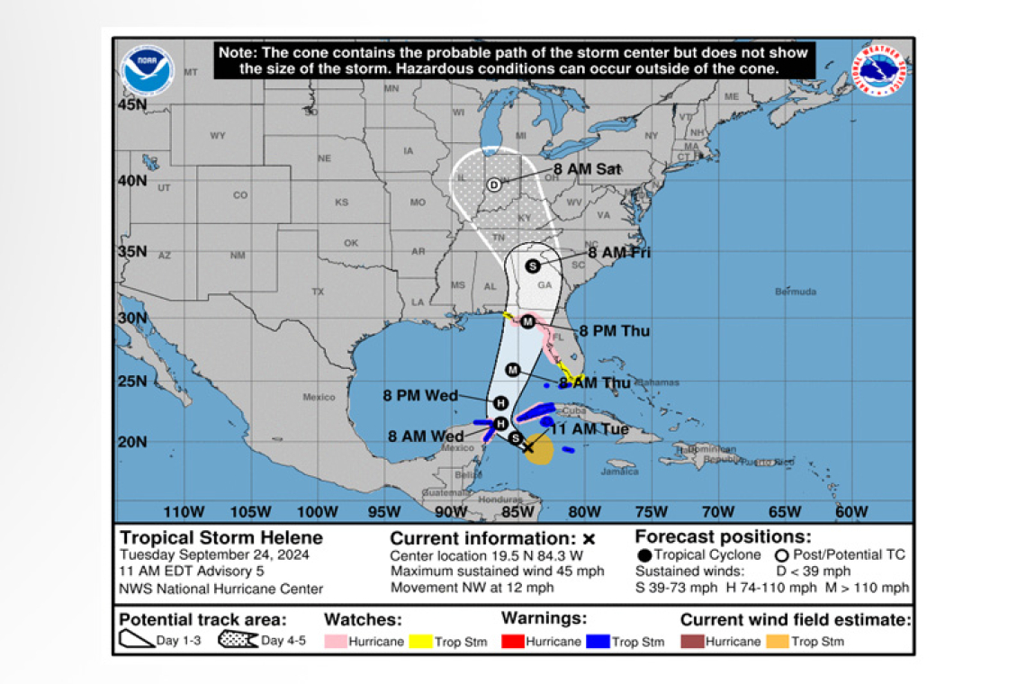
 At 1100 AM EDT (1500 UTC), the center of Tropical Storm Helene was located near latitude 19.5 North, longitude 84.3 West. Helene is moving toward the northwest near 12 mph (19 km/h), and this general motion is expected to continue through early Wednesday. A northward to north-northeastward motion at a faster forward speed is expected on Wednesday and Thursday. On the forecast track, the center of Helene will move across the far northwestern Caribbean Sea through tonight, and then move across the eastern Gulf of Mexico Wednesday and Thursday, potentially reaching the Gulf coast
of Florida late Thursday.
Data from an Air Force Reserve Hurricane Hunter aircraft indicate that the system has acquired a well-defined center of circulation, and maximum sustained winds have increased to near 45 mph (75 km/h) with higher gusts. Additional strengthening is forecast, and Helene is expected to become a hurricane on Wednesday. Continued strengthening is anticipated after that time, and Helene could become a major hurricane on Thursday.
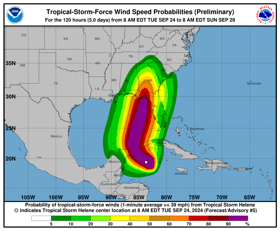
Tropical-storm-force winds extend outward up to 140 miles (220 km) to the east of the center.
Data from the Hurricane Hunter aircraft indicate that the minimum central pressure is 1000 mb (29.53 inches).
HAZARDS AFFECTING LAND
----------------------
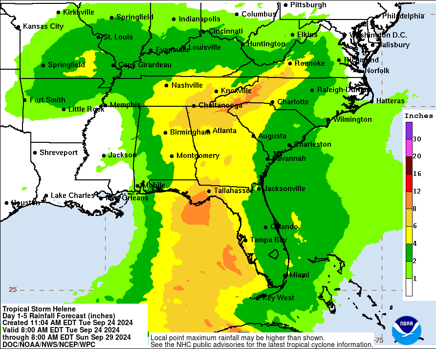
RAINFALL: Helene is expected to produce total rain accumulations of 4 to 8 inches over western Cuba and the Cayman Islands with isolated totals around 12 inches. Over the eastern Yucatan Peninsula, 4 to 6 inches of rain are expected with isolated totals over 8 inches. This rainfall brings a risk of consid-erable flooding.
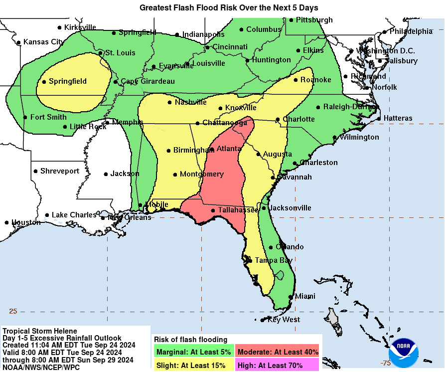
Over the Southeastern U.S., Helene is expected to produce total rain accumulations of 4 to 8 inches with isolated totals around 12 inches. This rainfall will likely result in areas of considerable flash and urban flooding, with minor to moderate river flooding likely, and isolated major river flooding possi-ble.
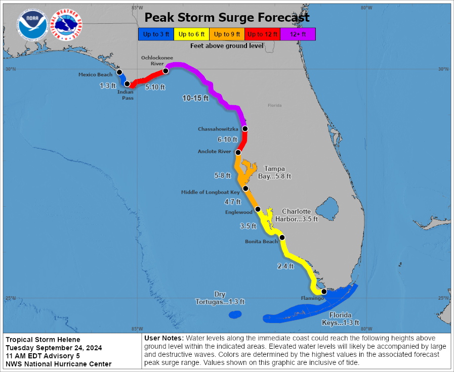
STORM SURGE: The combination of a dangerous storm surge and the tide will cause normally dry ar-eas near the coast to be flooded by rising waters moving inland from the shoreline. The water could reach the following heights above ground somewhere in the indicated areas if the peak surge occurs at the time of high tide...
Ochlockonee River, FL to Chassahowitzka, FL...10-15 ft
Chassahowitzka, FL to Anclote River, FL...6-10 ft
Indian Pass, FL to Ochlockonee River, FL...5-10 ft
Anclote River, FL to Middle of Longboat Key, FL...5-8 ft
Tampa Bay...5-8 ft
Middle of Longboat Key, FL to Englewood, FL...4-7 ft
Englewood, FL to Bonita Beach, FL...3-5 ft
Charlotte Harbor...3-5 ft
Storm surge could raise water levels by as much as 2 to 4 feet above normal tide levels in areas of onshore winds along the southern coast of Pinar del Rio, Cuba, including the Isle of Youth.
Storm surge could raise water levels by as much as 2 to 4 feet above ground level in areas of onshore winds within the warning area along the east coast of the Yucatan Peninsula.
WIND: Hurricane conditions are possible within the watch areas in Cuba and Mexico by early Wednesday. Hurricane conditions are possible within the U.S. watch areas Wednesday night and early Thursday. Tropical storm conditions are expected in the warning areas in the Cayman Islands, Cuba, and Mexico today. Tropical storm conditions are expected in the warning area in the Lower Florida Keys beginning on Wednesday, and are possible in the watch area in the Middle Florida Keys begin-ning late Wednesday.
SURF: Swells generated by Helene will affect the southern coast of Cuba and the Yucatan Peninsula of Mexico during the next couple of days. Swells will spread northward toward the west coast of Florida and the northeastern Gulf Coast on Wednesday and Thursday. These swells are likely to cause life-threatening surf and rip current conditions. Please consult products from your local weather of-fice.
Forecaster Berg


