...GUSTY WINDS AND HEAVY RAINS STILL OCCURRING OVER PORTIONS OF SOUTH FLORIDA AND THE FLORIDA KEYS...
Tropical Storm Eta Advisory Number 37
NWS National Hurricane Center Miami FL AL292020
1000 AM EST Mon Nov 09 2020

SUMMARY OF 1000 AM EST...1500 UTC...INFORMATION
-----------------------------------------------
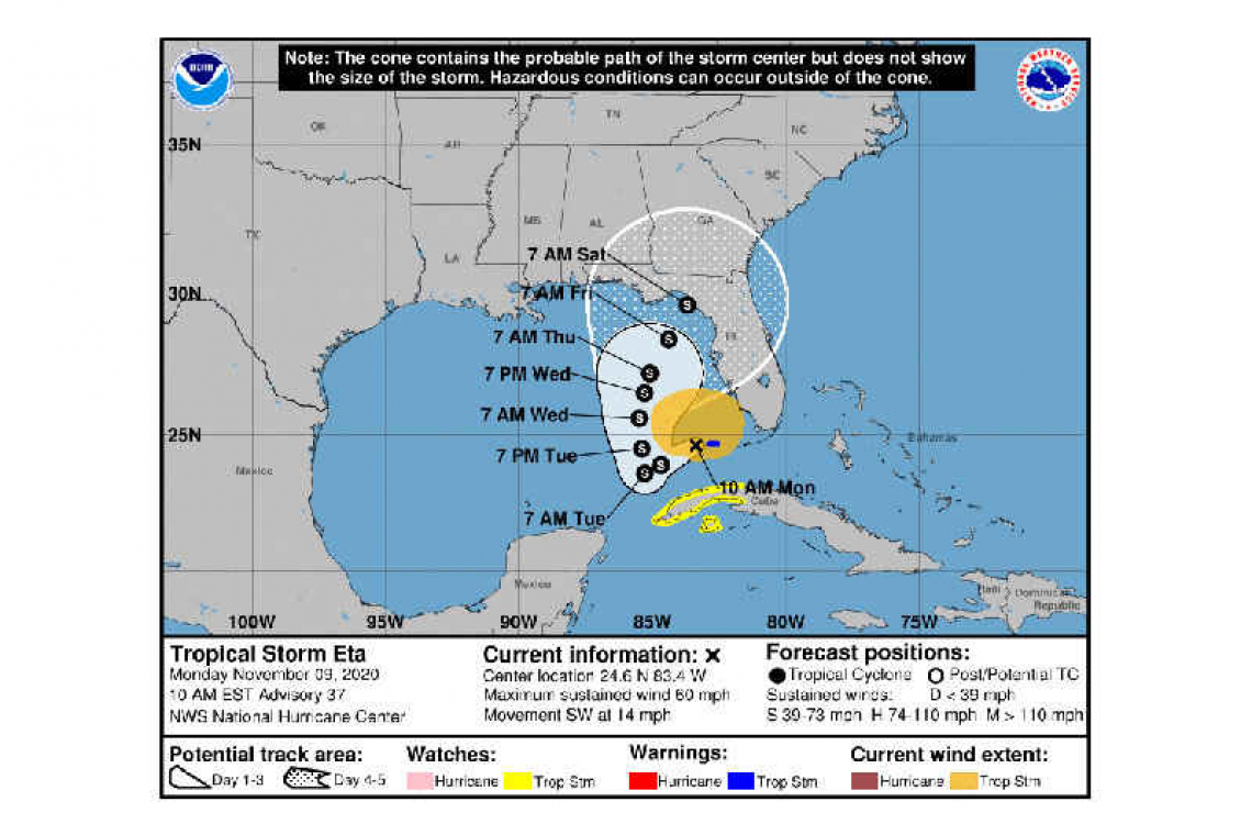
LOCATION...24.6N 83.4W
ABOUT 30 MI...50 KM WSW OF THE DRY TORTUGAS
ABOUT 210 MI...335 KM NNE OF THE WESTERN TIP OF CUBA
MAXIMUM SUSTAINED WINDS...60 MPH...95 KM/H
PRESENT MOVEMENT...SW OR 235 DEGREES AT 14 MPH...22 KM/H
MINIMUM CENTRAL PRESSURE...994 MB...29.36 INCHES
WATCHES AND WARNINGS
--------------------
CHANGES WITH THIS ADVISORY:
The Tropical Storm Warning has been discontinued for all of the Florida peninsula and the Florida Keys, excluding the Dry Tortugas.
SUMMARY OF WATCHES AND WARNINGS IN EFFECT:
A Tropical Storm Warning is in effect for...
* Dry Tortugas
A Tropical Storm Watch is in effect for...
* The Cuban provinces of La Habana, Artemisa, Mayabeque, Pinar del Rio, and the Isle of Youth
A Tropical Storm Warning means that tropical storm conditions are expected somewhere within the warning area, in this case within the next 6 to 12 hours.
A Tropical Storm Watch means that tropical storm conditions are possible within the watch area, generally within 48 hours.
Interests along the Gulf Coast of Florida should monitor the progress of Eta.
For storm information specific to your area in the United States, including possible inland watches and warnings, please monitor products issued by your local National Weather Service forecast office. For storm information specific to your area outside of the United States, please monitor products issued by your national meteorological service.
DISCUSSION AND OUTLOOK
----------------------
At 1000 AM EST (1500 UTC), the center of Tropical Storm Eta was located by an Air Force Reserve reconnaissance aircraft and NOAA Doppler weather radars near latitude 24.6 North, longitude 83.4 West. Eta is moving toward the southwest near 14 mph (22 km/h), and this motion with some reduction in forward speed is expected to continue through tonight. Little overall motion is forecast on Tuesday and a slow northward motion is expected on Wednesday. On the forecast track, the center of Eta will continue to move away from the Florida Keys and south Florida today, and will remain over the southeastern Gulf of Mexico tonight through Wednesday.
Data from the aircraft and Doppler radars indicate that maximum sustained winds have decreased to near 60 mph (95 km/h) with higher gusts. Little change in strength is expected today and tonight. Some slight strengthening is forecast on Tuesday into Wednesday, followed by gradual weakening thereafter.
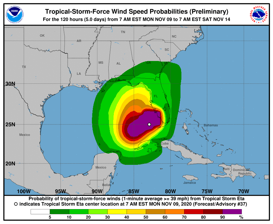
Tropical-storm-force winds extend outward up to 150 miles (240 km) from the center.
The estimated minimum central pressure based on reports from the aircraft is 994 mb (29.36 inches).
HAZARDS AFFECTING LAND
----------------------

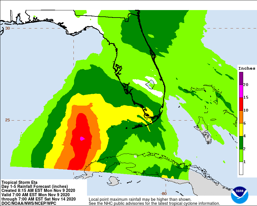
RAINFALL: Eta is expected to produce the following rainfall amounts through Saturday morning:
The Bahamas: An additional 1 to 3 inches (25 to 75 mm), with isolated maximum storm totals of 15 inches (380 mm).
Portions of Cuba: an additional 3 to 5 inches (75 to 125 mm), isolated maximum storm total accumulations of 25 inches (635 mm).
Portions of the central and southern Florida peninsula, including the Keys: an additional 2 to 4 inches (50 to 100 mm)), with isolated maximum storm totals of 18 inches (450 mm) in South Florida.
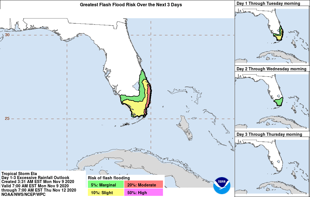
Flash flooding and river flooding will be possible in Cuba, along with landslides in areas of higher terrain. Life-threatening flash flooding will be possible across saturated urban areas of southeast Florida. Flash and urban flooding will also be possible for the Bahamas and the remainder of southern and eastern Florida over the next several days. Minor river flooding is also possible for central Florida.
WIND: Gusty conditions will continue across the Florida Keys, south and central Florida, and the northwestern Bahamas today. Tropical storm conditions are possible in the Tropical Storm Watch area in Cuba tonight and Tuesday.

TORNADOES: A tornado or two is possible today over parts of south Florida and the Keys.
SURF: Swells generated by Eta are expected to affect the north coast of Cuba, the northwestern Bahamas, southern Florida and the Florida Keys during the next couple of days. These swells are likely to cause life-threatening surf and rip current conditions. Please consult products from your local weather office.
Forecaster Stewart


