
...PREPARATIONS TO PROTECT LIFE AND PROPERTY SHOULD BE RUSHED TO COMPLETION...
Hurricane Helene Intermediate Advisory Number 12A
NWS National Hurricane Center Miami FL AL092024
700 AM CDT Thu Sep 26 2024
SUMMARY OF 700 AM CDT...1200 UTC...INFORMATION
----------------------------------------------
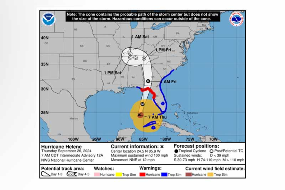
 LOCATION...24.5N 85.9W
ABOUT 320 MI...515 KM SW OF TAMPA FLORIDA
ABOUT 365 MI...585 KM S OF APALACHICOLA FLORIDA
MAXIMUM SUSTAINED WINDS...100 MPH...155 KM/H
PRESENT MOVEMENT...NNE OR 15 DEGREES AT 12 MPH...19 KM/H
MINIMUM CENTRAL PRESSURE...960 MB...28.35 INCHES
WATCHES AND WARNINGS
--------------------
 CHANGES WITH THIS ADVISORY:
None.
SUMMARY OF WATCHES AND WARNINGS IN EFFECT:
A Storm Surge Warning is in effect for...
* Mexico Beach eastward and southward to Flamingo
* Tampa Bay
* Charlotte Harbor
A Hurricane Warning is in effect for...
* Anclote River to Mexico Beach
A Hurricane Watch is in effect for...
* Englewood to Anclote River, including Tampa Bay
A Tropical Storm Warning is in effect for...
* Florida Keys, including the Dry Tortugas
* Flamingo to Anclote River, including Tampa Bay
* West of Mexico Beach to the Okaloosa/Walton County Line
* Flamingo northward to Little River Inlet
* Lake Okeechobee
* Cuban provinces of Artemisa, Pinar del Rio, and the Isle of Youth
 A Storm Surge Warning means there is a danger of life-threatening inundation, from rising water moving inland from the coastline. This is a life-threatening situation. Persons located within these ar-eas should take all necessary actions to protect life and property from rising water and the potential for other dangerous conditions. Promptly follow evacuation and other instructions from local offi-cials.
A Hurricane Warning means that hurricane conditions are expected somewhere within the warning area. Preparations to protect life and property should be rushed to completion.
A Tropical Storm Warning means that tropical storm conditions are expected somewhere within the warning area.
A Storm Surge Watch means there is a possibility of life-threatening inundation, from rising water moving inland from the coastline.
A Hurricane Watch means that hurricane conditions are possible within the watch area.
For storm information specific to your area in the United States, including possible inland watches and warnings, please monitor products issued by your local National Weather Service forecast office. For storm information specific to your area outside of the United States, please monitor products issued by your national meteorological service.
DISCUSSION AND OUTLOOK
----------------------
 At 700 AM CDT (1200 UTC), the center of Hurricane Helene was located near latitude 24.5 North, lon-gitude 85.9 West. Helene is moving toward the north-northeast near 12 mph (19 km/h). This general motion is expected to continued with a significant increase in forward speed during the next 24 hours. On the forecast track, Helene will move across the eastern Gulf of Mexico today and cross
the Florida Big Bend coast this evening or early Friday morning.
After landfall, Helene is expected to turn northwestward and slow down over the Tennessee Valley on Friday and Saturday.
Maximum sustained winds have increased to near 100 mph (155 km/h) with higher gusts. Additional strengthening is forecast, and Helene is expected to be a major hurricane when it reaches the Florida Big Bend coast this evening. Weakening is expected after landfall, but Helene's fast forward speed will allow strong, damaging winds, especially in gusts, to penetrate well inland across the southeast-ern United States, including over the higher terrain of the southern Appalachians.
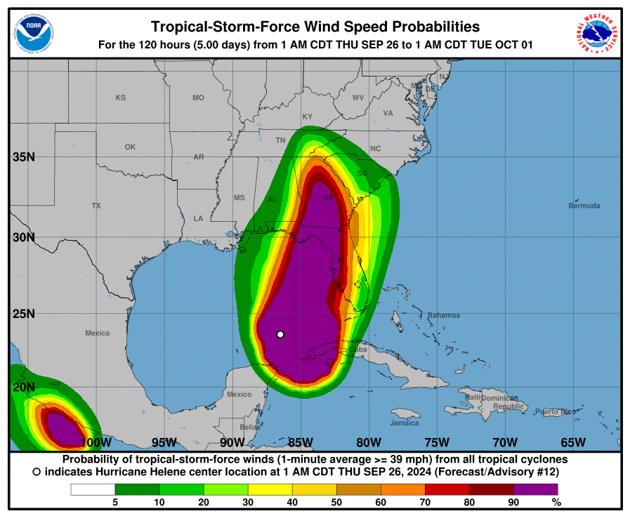
Hurricane-force winds extend outward up to 60 miles (95 km) from the center and tropi-cal-storm-force winds extend outward up to 345 miles (555 km). The Key West Naval Air Station re-cently reported sustained winds of 41 mph (66 km/h) and a wind gust of 55 mph (89 km/h). An ob-servation in Sand Key recently reported sustained winds of 45 mph (72 km/h) and a gust to 58 mph (93 km/h).
The estimated minimum central pressure based on data from the NOAA and Air Force Reserve Hurri-cane Hunter aircraft is 960 mb (28.35 inches).
HAZARDS AFFECTING LAND
----------------------
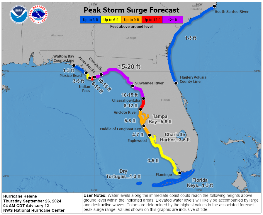
STORM SURGE: The combination of a life-threatening storm surge and the tide will cause normally dry areas near the coast to be flooded by rising waters moving inland from the shoreline. The water could reach the following heights above ground somewhere in the indicated areas if the peak surge occurs at the time of high tide...
Carrabelle, FL to Suwannee River, FL...15-20 ft
Apalachicola, FL to Carrabelle, FL...10-15 ft
Suwannee River, FL to Chassahowitzka, FL...10-15 ft
Chassahowitzka, FL to Anclote River, FL...8-12 ft
Indian Pass, FL to Apalachicola, FL...6-10 ft
Anclote River, FL to Middle of Longboat Key, FL...5-8 ft
Tampa Bay...5-8 ft
Middle of Longboat Key, FL to Englewood, FL...4-7 ft
East of Mexico Beach, FL to Indian Pass, FL...3-5 ft
Englewood, FL to Flamingo, FL...3-5 ft
Charlotte Harbor...3-5 ft
Storm surge could raise water levels by as much as 2 to 4 feet above normal tide levels in areas of onshore winds along the southern coast of Pinar del Rio, Cuba, including the Isle of Youth.
WIND: Hurricane conditions are expected within the U.S. hurricane warning area late today. Tropi-cal storm conditions have already begun in the Florida Keys and portions of south Florida, and these conditions are expected to spread northward across the state and into Georgia and South Carolina through
tonight.
Tropical storm conditions are expected over portions of the warning area in western Cuba during the next few hours.
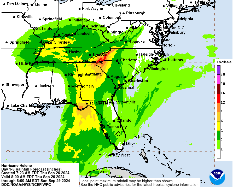
RAINFALL: Hurricane Helene is expected to produce total rain accumulations of 4 to 8 inches over western Cuba, the Cayman Islands and the northeast Yucatan Peninsula, with isolated totals around 12 inches. This rainfall brings a risk of considerable flooding.
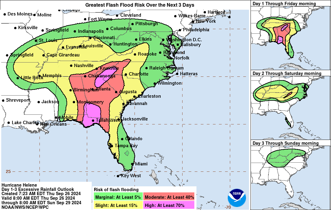
Over portions of the Southeastern U.S. into the Southern Appalachians, Helene is expected to pro-duce total rain accumulations of 6 to 12 inches with isolated totals around 18 inches. This rainfall will likely result in catastrophic and potentially
life-threatening flash and urban flooding, along with significant river flooding. Numerous landslides are expected in steep terrain across the southern Appalachians.
TORNADOES: The risk for several tornadoes will gradually increase today through tonight. The great-est threat is expected from parts of northern Florida into southeast Georgia, the Midlands and Low Country of South Carolina, and southern North Carolina.
SURF: Swells generated by Helene will affect much of Florida and the coasts of Georgia and the Caro-linas during the next couple of days. Swells will also continue across portions of Cuba and the Yucatan Peninsula through tonight. These swells are likely to cause life-threatening surf and rip current condi-tions. Please consult products from your local weather office.
Forecaster Cangialos


