
...LIFE-THREATENING STORM SURGE, WINDS, AND HEAVY RAINS
CONTINUE…
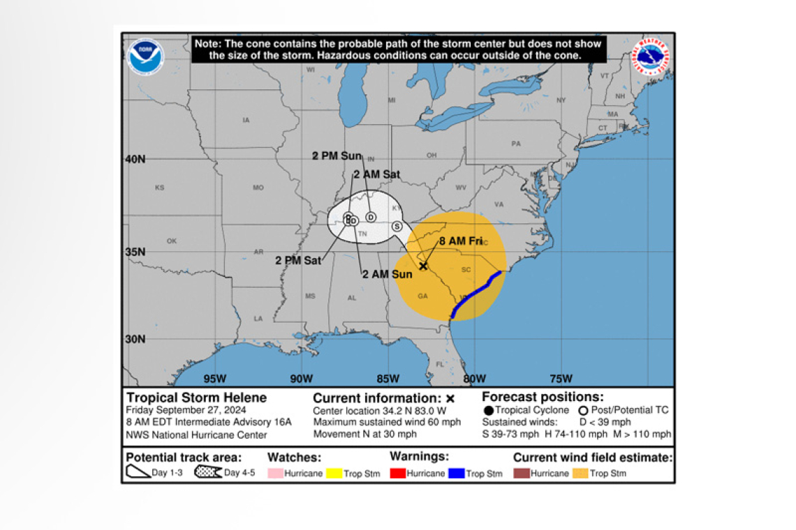
Tropical Storm Helene Intermediate Advisory Number 16A
NWS National Hurricane Center Miami FL AL092024
800 AM EDT Fri Sep 27 2024
...HELENE PRODUCING DAMAGING GUSTY WINDS AND LIFE-THREATENING
FLOODING OVER PORTIONS OF THE SOUTHEAST AND SOUTHERN APPALACHIANS...
...FLASH FLOOD EMERGENCY IN EFFECT FOR METROPOLITAN ATLANTA...
SUMMARY OF 800 AM EDT...1200 UTC...INFORMATION
----------------------------------------------
 LOCATION...34.2N 83.0W
ABOUT 35 MI...60 KM SSW OF CLEMSON SOUTH CAROLINA
ABOUT 80 MI...130 KM ENE OF ATLANTA GEORGIA
MAXIMUM SUSTAINED WINDS...60 MPH...95 KM/H
PRESENT MOVEMENT...N OR 360 DEGREES AT 30 MPH...48 KM/H
MINIMUM CENTRAL PRESSURE...972 MB...28.70 INCHES
WATCHES AND WARNINGS
--------------------
 CHANGES WITH THIS ADVISORY:
The Tropical Storm Warning along the Florida Gulf Coast from the mouth of the Suwannee River to Indian Pass has been discontinued. The Tropical Storm Warning along the east coast of Florida and extreme southeastern Georgia from the Flagler/Volusia County Line to Altamaha Sound has been dis-continued.
The Storm Surge Warning for the Florida coast has been discontinued south of the Middle of Long-boat Key.
SUMMARY OF WATCHES AND WARNINGS IN EFFECT:
A Storm Surge Warning is in effect for...
* Indian Pass to Middle of Longboat Key, Florida
* Tampa Bay
A Tropical Storm Warning is in effect for...
* Altamaha Sound northward to Little River Inlet
A Storm Surge Warning means there is a danger of life-threatening inundation, from rising water moving inland from the coastline. This is a life-threatening situation.
A Tropical Storm Warning means that tropical storm conditions are expected somewhere within the warning area.
For storm information specific to your area in the United States, including possible inland watches and warnings, please monitor products issued by your local National Weather Service
forecast office.
DISCUSSION AND OUTLOOK
----------------------
 At 800 AM EDT (1200 UTC), the center of Tropical Storm Helene was located near latitude 34.2 North, longitude 83.0 West. Helene is moving toward the north near 30 mph (48 km/h). Helene is expected to turn northwestward and slow down over the Tennessee Valley later today and Saturday.
Maximum sustained winds have decreased to near 60 mph (95 km/h) with higher gusts. Continued weakening is expected, and Helene is expected to become a post-tropical low this afternoon or to-night. However, damaging wind gusts will penetrate far inland across the southeastern United States, including over the higher terrain of the southern Appalachians.
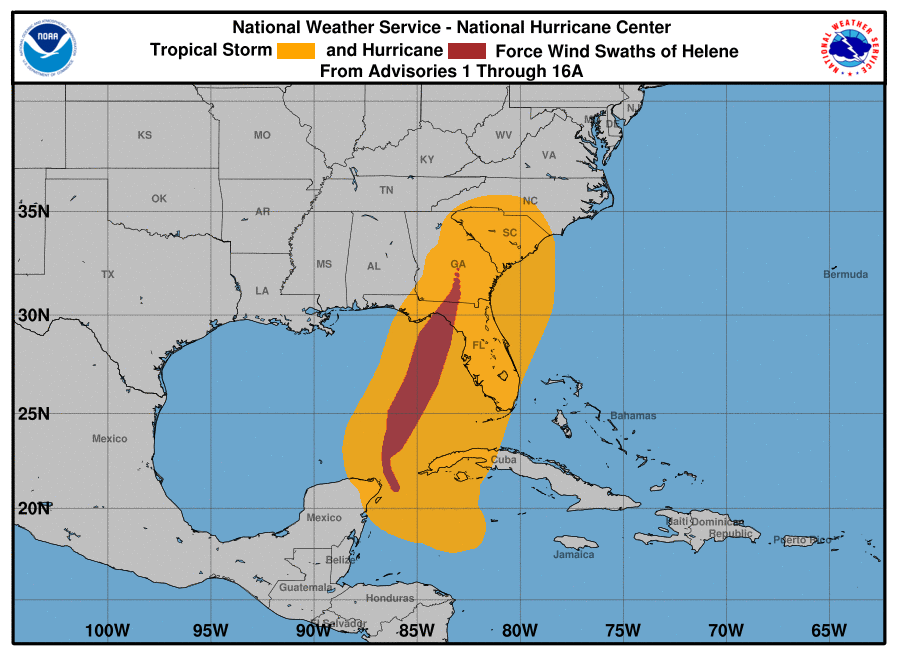
Tropical-storm-force winds extend outward up to 275 miles (445 km) mainly to the east of the center. An observation in Brasstown Bald, Georgia recently reported a wind gust of 72 mph (116 km/h). An observation in Dewees Island, South Carolina, recently reported a sustained wind of 46 mph (74 km/h) and a gust of 62 mph (100 km/h).
The minimum central pressure based on surface observations is 972 mb (28.70 inches).
HAZARDS AFFECTING LAND
----------------------
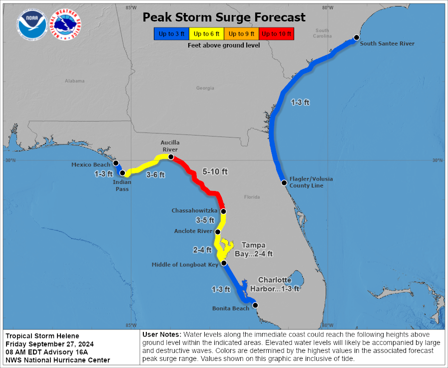 STORM SURGE: The combination of a life-threatening storm surge and the tide will cause normally dry areas near the coast to be flooded by rising waters moving inland from the shoreline. The water could reach the following heights above ground somewhere in the indicated areas if the peak surge occurs at the time of high tide...
Aucilla River, FL to Chassahowitzka, FL...5-10 ft
Indian Pass, FL to Aucilla River, FL...3-6 ft
Chassahowitzka, FL to Anclote River, FL...3-5 ft
The deepest water will occur along the immediate coast near and to the east of the landfall location, where the surge will be accompanied by large and dangerous waves. Surge-related flooding depends on the relative timing of the surge and the tidal cycle, and can vary greatly over short distances. For information specific to your area, please see products issued by your local National Weather Service
forecast office.
WIND: Tropical storm conditions are occurring along much of the Georgia and South Carolina coasts, and these conditions will continue for the next several hours. Strong, damaging winds, especially in gusts, will also continue as far inland as the higher terrain of the southern Appalachians.
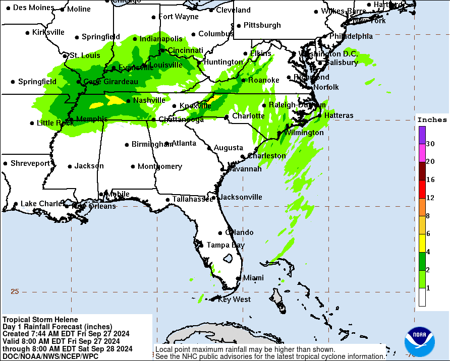
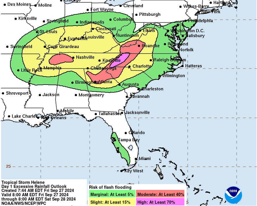
RAINFALL: Over portions of the Southeastern U.S. into the Southern Appalachians, Helene is expected to produce total rain accumulations of 6 to 12 inches, with isolated totals around 20 inches. This rain-fall will likely result in catastrophic and potentially life-threatening flash and urban flooding, along with significant and record river flooding. Numerous significant landslides are expected in steep ter-rain across the southern Appalachians.
TORNADOES: Tornadoes are possible this morning over parts of eastern Georgia, and through this af-ternoon over the Carolinas and southern Virginia.
SURF: Swells generated by Helene will affect the coasts of Georgia and the Carolinas during the next day or so. These swells are likely to cause life-threatening surf and rip current conditions. Please con-sult products from your local weather office.
Forecaster Cangialosi/Harrigan


